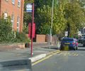
FR:Key:kerb
 |
| Description |
|---|
| Indique la hauteur d’un ressaut. |
| Groupe: voirie |
| Utilisé pour ces éléments |
| Combinaisons utiles |
| Statut : de fait |
| Outils pour cet attribut |
Un ressaut est la délimitation entre la chaussée et un ![]() trottoir. La localisation des ressauts est importante pour les personnes se déplaçant à pied, à vélo et surtout pour les personnes à mobilité réduite (par exemple en fauteuil roulant), car constituent des transitions tant en terme de hauteurs que de revêtements.
trottoir. La localisation des ressauts est importante pour les personnes se déplaçant à pied, à vélo et surtout pour les personnes à mobilité réduite (par exemple en fauteuil roulant), car constituent des transitions tant en terme de hauteurs que de revêtements.
La clé est kerb=*, à utiliser sur un nœud appartenant à highway=footway, highway=cycleway ou highway=path à l'endroit où est située la bordure (à la limite avec la route).
Utilisation
L’attribut est à utiliser sur le nœud ![]() où le
où le highway=footway, highway=cycleway, ou highway=path est interrompu par le ressaut. Les différentes valeurs possibles sont décrites dans le tableau ci-dessous.
Si la bordure est identique des deux côtés d'une traversée de chaussée et qu’il est impossible de distinguer les deux ressauts, il est possible d'ajouter kerb=* au nœud highway=crossingce qui sacrifie en partie la précision au profit de la simplicité. Dans une telle situation, il convient d'utiliser kerb:left et kerb:right si les bordures sont différentes.
Les hauteurs renseignées sont à titre indicatif et le choix d'une valeur devrait uniquement dépendre de considérations fonctionnelles. En d'autres termes, il vaut mieux penser à l'accessibilité pour les personnes à mobilité réduite qu'à la hauteur spécifique de la bordure lors du choix de la valeur.
| Valeur | Hauteur habituelle | Implique | Usage habituel | Description | Exemple |
|---|---|---|---|---|---|
no
|
— | wheelchair=yes
|
Absence de ressaut. Peut être utile si celui-ci a été retiré ou n’existe pas là où l’on s’y attendrait. Il peut notamment servir à indiquer une entrée charretière, carrosable, ou plus communément appelée bateau. | ||
flush
|
~ 0 cm | wheelchair=yes
|
Traversée de chaussée | Similaire à lowered, la différence étant que la transition est difficilement perçue par voie tactile et nécessite la présence de tactile_paving=*.
|
|
lowered
|
~ 3 cm | wheelchair=yes
|
Traversée de chaussée | Ressaut abaissé, facilitant son franchissement.
À utiliser en remplacement de |
|
raised
|
> 3 cm | wheelchair=no†
|
Arrêts de bus | Ressauts élevés, ne répondant généralement plus aux normes pour les traversées de chaussée. Est utilisé comme plateforme d’accès aux arrêts de bus.
† : Lorsque utilisé sur des cheminements piétons, implique |
|
rolled
|
— | wheelchair=no
|
Rues résidentielles | Ressaut chanfreiné de manière à former un caniveau pour l’évacuation des eaux tout en restant franchissable pour les véhicules à roues larges (excluant les fauteuils roulants). Généralement utilisé dans les zones à faible trafic.
À ne pas confondre avec |
|
yes
|
Indéterminé | wheelchair=no‡
|
Présence d’un ressaut de taille indéterminée. Utile dans le cas de cartographie à l’aide d’imagerie aérienne.
‡ : Peut être interprété, par précaution, comme |
Hauteur du ressaut
Si la hauteur exacte du ressaut est connue, elle peut également être indiquée via kerb:height=*. L’unité par défaut est le mètre, une unité différente peut être indiquée explicitement :
0.12– ressaut de 0,12 m (12 cm) ;4 cm– ressaut de 6 cm ;6"– ressaut de 6 pouces.
Exemples
| Photo | Attributs |
|---|---|
 |
Arrêt de tram avec un ressaut surélevé, un ressaut abaissé à la traversée, et un ressaut usuel. |
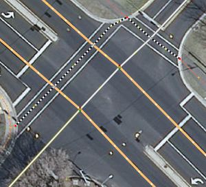 |
Les nœuds en rouge, portent kerb=lowered, les traversées highway=footway et footway=crossing, les intersection de voies highway=crossing et crossing=traffic_signals.
|
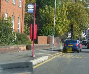 |
Ajouter kerb=raised sur l’arrêt de bus ou la plateforme. Implique que le ressaut concerné est celui entre l’arrêt et la chaussée.
|
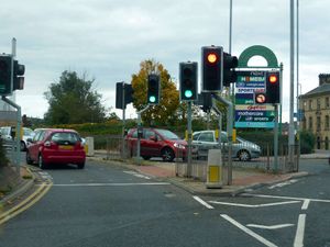 |
Ajouter kerb=lowered sur le footway=traffic_island à l’emplacement des ressauts ou sur highway=crossing si identiques de part et d’autre.
|
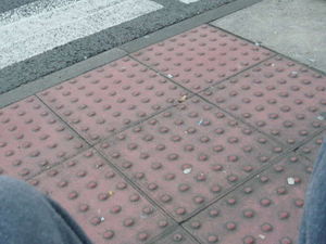 |
Ajouter kerb=flush et tactile_paving=yes à leurs positions respectives sur le highway=footway ou sur highway=crossing si identiques de part et d’autre de la traversée de chaussée.
|
Attributs liés
kerb=* peut aussi être accompagné de tactile_paving=* pour aider les personnes malvoyantes, en particulier sur les kerb=flush.
JOSM
Avec JOSM, le Map Paint Style Sidewalks and footways (with knobs on) peut être utilisé pour mettre en évidence les kerb=* utilisés sur des nœuds ![]() :
:
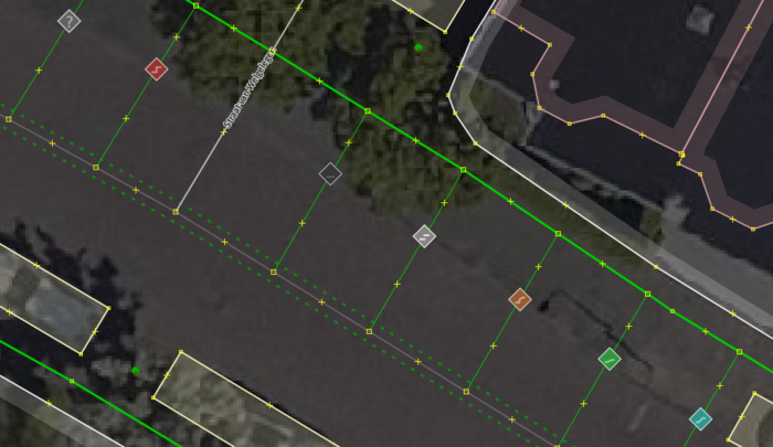
kerb=*sont représentées par des icônes propres.Erreur usuelles
Voir aussi
- Steps features
- Barrier
- Wheelchair
- Tactile paving
- Proposed features/Traffic island
- Proposed features/sloped curb
- Proposed features/right left
- Relations/Proposed/Area
Liens externes
- Wikipedia articles on kerb, and curb cut
- FHWA: Designing Sidewalks and Trails for Access, Chapter 7. Curb Ramps (en) - Par la "US Federal Highways Administration", tout ce que vous avez toujours voulu savoir sur les rampes de trottoirs. D'autres chapitres de ce guide pourraient aussi s'avérer utiles.


