Featured images/Oct-Dec 2014
< Featured images(Redirected from Featured Images/Oct-Dec 2014)
Jump to navigation
Jump to search

These are featured images, which have been identified as the best examples of OpenStreetMap mapping, or as useful illustrations of the OpenStreetMap project.
If you know another image of similar quality, you can nominate it on Featured image proposals.
| ← from October to December 2013 | ← from July to September 2014 | from January to March 2015 → | from October to December 2015 → |
Gallery of featured images, from October to December 2014
2014, week 40

2014, week 41
2014, week 42

2014, week 43

2014, week 44

2014, week 45

2014, week 46
2014, week 47
2014, week 48
2014, week 49
2014, week 50
2014, week 51

2014, week 52
Details and captions
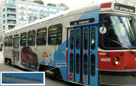
Week 40 (from Monday 29 September 2014 to Sunday 5 October 2014) [Edit]

- English : This advertisement on the side of a tram in Toronto features a large map from OpenStreetMap! Commercial use of OpenStreetMap is allowed and encouraged (when people follow the copyright instructions correctly like this) and we love to see our maps appearing in interesting places.
Week 41 (from Monday 6 October 2014 to Sunday 12 October 2014) [Edit]

- English : Uwe Engstler, a german teacher from the Comenius project "My City and my History in OSM", teaching students from Archbishop Sentamu Academy, Kingston upon Hull, UK, how to use OSMTracker for mapping historic monuments
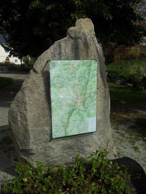
Week 42 (from Monday 13 October 2014 to Sunday 19 October 2014) [Edit]

- English : A walking map display board mounted on a rock. Holger Schöner has produced hiking and cycling maps in various forms around the area of Gutau (a small village in Upper Austria) Read more (in German)
Week 43 (from Monday 20 October 2014 to Sunday 26 October 2014) [Edit]

- English : This month, Nate Wessel published a full-color cycle map of Cincinnati, Ohio, United States, based on OpenStreetMap data. A print run of 9,000 is being distributed locally. Unlike many urban cycle maps, which highlight a curated selection of "preferred" routes for cyclists, the Cincinnati Bike Map indicates road conditions for all roads.
Week 44 (from Monday 27 October 2014 to Sunday 2 November 2014) [Edit]

- English : OpenStreetMap mappers from Togo, Senegal, Burkina Faso, Niger, Côte d'Ivoire and Benin, meeting in Lomé. International Organisation internationale de la Francophonie (OIF) is promoting OpenStreetMap in Africa, particularly in the french speaking countries
Week 45 (from Monday 3 November 2014 to Sunday 9 November 2014) [Edit]

- English : A first meeting in Quito, Ecuador to strengthen the Ecuadorian OpenStreetMap Community and to promote and disseminate the use of free geographic data in the country. The meeting was organized by the Community of Free Software and Computer Security Hackem in the "Escuela Politécnica Nacional".
Week 46 (from Monday 10 November 2014 to Sunday 16 November 2014) [Edit]

- English : The international conference, State Of The Map 2014, took place in Buenos Aires this weekend
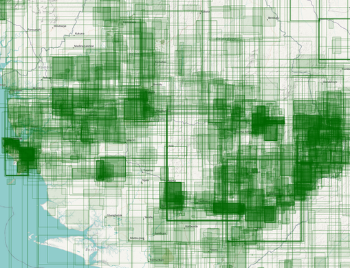
Week 47 (from Monday 17 November 2014 to Sunday 23 November 2014) [Edit]

- English : Thanks to the more than 2,000 mappers who made more than 10,000,000 map-changes in the ebola area since March! The changes are visualized on a map from Pascal Neis. In a blog post he presents more information about the involved contributors.
See the current HOT tasks.
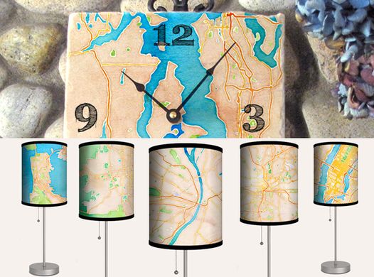
Week 48 (from Monday 24 November 2014 to Sunday 30 November 2014) [Edit]

- English : mapisart.com allows users to create lamps, coasters, clocks, trays, prints and wall canvases with OpenStreetMap data.
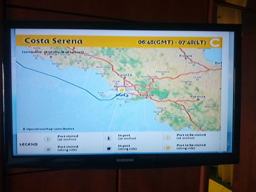
Week 49 (from Monday 1 December 2014 to Sunday 7 December 2014) [Edit]

- English : On Costa cruises, passengers can visualise the progress of the ships on many screens (inside the cabin, on interactive screens) featuring maps from OpenStreetMap
Week 50 (from Monday 8 December 2014 to Sunday 14 December 2014) [Edit]

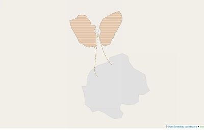
- English : Mapping curiosities: This butterfly, or perhaps an angel, emerged on the map while mapping water wells in Niger.(see it here on the map)
Week 51 (from Monday 15 December 2014 to Sunday 21 December 2014) [Edit]

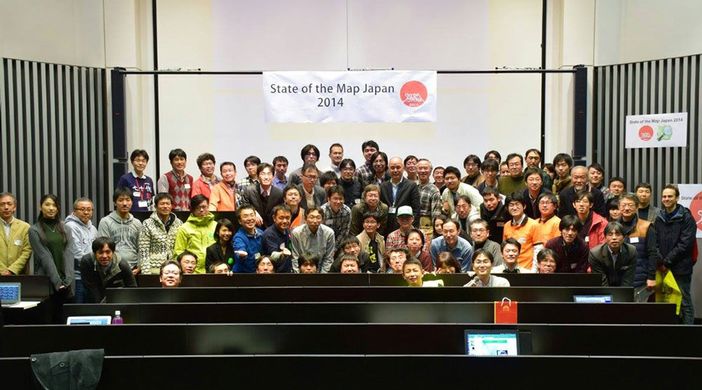
- English : The State of the Map Japan 2014 was held in Tokyo on Dec 13, 2014
Week 52 (from Monday 22 December 2014 to Sunday 28 December 2014) [Edit]

- English : Santa hats and reindeer headgear at the Missing Maps Christmas Mapathon in London. Mappers gathered to do humanitarian mapping "putting the worlds vulnerable people on the map". One of a series of popular events called the Missing Maps Project