Key:cycleway:lane
 |
| Description |
|---|
| Type of cycle lane. |
| Group: cycleways |
| Used on these elements |
| Documented values: 4 |
| Status: de facto |
| Tools for this tag |
Subtag for cycleway=lane and cycleway=shared_lane to distinguish between the different types of cycle lanes.
There was a proposal to add cycleway=soft_lane to distinguish between exclusive and advisory cycleways, which was rejected in 2014 and then not pursued further for a time.
Instead, the tag on this page now makes it possible to map this distinction and is the outcome of several discussions in the forum.
Eligibility in countries
In Belgium, in France and in Norway, advisory cycle lanes do not exist, all real (not the shared lane ones) cycle lanes are exclusive to cyclists. Thus, adding cycleway:lane=exclusive or cycleway:lane=advisory to a cycleway=lane adds information that could be inferred from country specific rules. It only makes this information explicit in the data.
Both in Belgium and in Norway, all (non-sharrow, non-bus-lane) cycleway lanes have dashed road markings.
Values
| Tags | Description | Picture |
|---|---|---|
cycleway:both=lane + cycleway:both:lane=exclusive OR
|
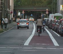
A cycle lane on both sides strictly reserved exclusively for cyclists, segregated from the car lanes usually through a continuous line (but not always, see section "Eligibility in countries" above). In most countries, this implies an obligation for cyclists to use it. The example picture has an exclusive lane only on the right side of the picture and would need cycleway:left=lane + cycleway:left:lane=exclusive, assuming the direction of the OSM way is pointing towards the camera.
|

|
cycleway:both=lane + cycleway:both:lane=advisory OR
|
A cycle lane on both sides which is not reserved exclusively for cyclists, i.e. cars may drive over and halt on it, exact legislation may differ. Usually marked with a dashed line. Often used in place of an exclusive cycle lane on roads where there is not enough space for both full car lanes and full cycle lanes, so that cyclists and other road users share the same space to a degree. In most countries where they exist, these cycle lanes are not obligatory for cyclists and are generally more narrow than exclusive cycle lanes because lower (safety) standards apply.
In English, this type of cycle lane is most commonly referred to as dashed cycle lane or advisory cycle lane. |

|
cycleway:both=shared_lane + cycleway:both:lane=pictogram OR
|
A Note: Not to be confused with: 1. bicycle pictograms that are painted on some one-way streets to indicate that cyclists are allowed to use the street in contraflow direction 2. bicycle pictograms that are painted on cycle streets ( |

|
cycleway:both=shared_lane + cycleway:both:lane=advisory OR
|
(Only) the Dutch and Belgians distinguish advisory cycle lanes from another type of very similar cycle lanes, so called suggestion cycle lanes (cycleway:both=shared_lane (if on both sides of the road). As other shared lane markings, these have no legal implications and thus are another way to indicate that cyclists and motorists share the road.
At least in Belgium, both these kind of cycle lane marking and pictogram corridors (sharrows) exist. |
Usages with :left and :right
Note: This wiki page describes the cycleway lane scheme in general. It is more precise to use the :left and :right modifier to explicitly define the situation on each side of the OSM way (not the car traffic direction) separately, in case it differs, or use :both in case it applies to both sides. Not using any modifier is sometimes incorrectly used for marking only the right side (or side near the sidewalk), especially in one-way streets. The scheme is the same. So, for example:
cycleway:both=lane+cycleway:both:lane=exclusiveorcycleway=lane+cycleway:lane=exclusive
Means that there is an exclusive cycle lane on both sidescycleway:both=lane+cycleway:right:lane=exclusive+cycleway:left:lane=advisory
Means that there is an exclusive cycle lane on the right side and an advisory cycle lane on the left side
cycleway:left:lane=* |
cycleway:right:lane=* |
cycleway:both:lane=* |