Ko:Key:smoothness
 |
| 설명 |
|---|
| 물리적인 도로 노면의 상태를 나타냅니다. |
| 그룹: 속성 |
| 해당 요소의 사용 |
| 유용한 조합 |
| 상태:승인 |
| 이 태그를 위한 도구 |
smoothness(평탄함)는 물리적인 도로 노면의 상태를 나타냅니다. 차량이 다른 장비의 도움을 받지 않고 도로를 피해 없이 지나갈 수 있는 것을 기준으로 합니다. 이 태그는 운전 가능한 구역(highway=*, 주차장 영역, 해변 등)이라면 얼마든지 넣을 수 있습니다.
tracktype=*도 도로 노면의 상태를 나타내지만, 일반적으로 노면의 평탄함보다는 노면의 단단함을 나타냅니다.
surface=*는 도로 포장재와 포장 구조를 나타냅니다. 이 태그만으로 도로의 평탄함을 나타낼 수도 있겠지만, 같은 포장재더라도 평탄함은 서로 다를 수 있기 때문에 smoothness=* 태그를 같이 써 주는 것이 좋습니다.
값
평탄함
| Key | Value | Element | Usable by | Description | Photo |
|---|---|---|---|---|---|
smoothness
|
excellent
|
(얇은 롤러) 롤러블레이드, 스케이트보드와 이하의 모든 차량 | As-new asphalt or concrete, smooth paving stones with seamless connections, etc. | 
| |
smoothness
|
good
|
(얇은 바퀴) 경주용 자전거와 이하의 모든 차량 | Asphalt or concrete showing the first signs of wear, such as narrow (<1.5 cm) cracks, wider cracks filled up with tar, shallow dents in which rainwater may collect, etc. that may cause trouble for rollers but not for racing bikes. The best roads paved with bricks, sett, etc. also fall in this category. | 
| |
smoothness
|
intermediate
|
(바퀴) 도시 자전거, 스포츠카, 휠체어, 스쿠터와 이하의 모든 차량 | Asphalt and equivalent that shows signs of maintenance such as patches of repaired pavement, wider cracks (>2 cm), etc. that may cause trouble for racing bikes. The pavement may contain potholes, but these are small, shallow (<3cm deep) and few so they are easily avoided, or the road shows damage due to subsidence (depressions of a scale >50 cm) or heavy traffic (shallow ruts in asphalt caused by trucks in summer). The quality of the surface starts to affect the speed of most passenger cars, so they will slow down to make the ride more comfortable (but still above 50% of the speed they would drive at if the road was smooth). The best unpaved but compacted roads fall in this category. | 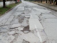
| |
smoothness
|
bad
|
(견고한 바퀴) 트래킹 자전거, 일반적인 자동차, 인력거와 이하의 모든 차량 | Heavily damaged paved roads that badly need maintenance: many potholes, some of them quite deep. The average speed of cars is less than 50% of what it would be on a smooth road. However, it isn’t so rough that ground clearance becomes a problem. A ground clearance of a normal passenger car (>14 cm) is sufficient. Good unpaved roads without risk of damage to normal passenger cars are also included here. | 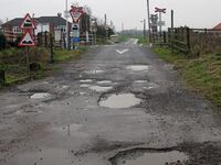 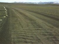
| |
smoothness
|
very_bad
|
(차체 바닥이 높음) 경헝 오프로드 차종과 이하의 모든 차량 | Unpaved roads with potholes and ruts, but still passable with an average SUV with a ground clearance of at least 18 cm.* | 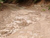
| |
smoothness
|
horrible
|
(오프로드) 중형 오프로드 차종과 이하의 모든 차량 | Unpaved tracks with ruts, rocks etc that need a ground clearance of at least 21 cm (Toyota Landcruiser, Landrover, Lada Niva, bukhanka, etc.). Skid plate protection is advisable. | 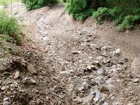
| |
smoothness
|
very_horrible
|
(특수 오프로드) 트랙터, ATV, 트라이얼 바이크, 산악 자전거 등. 모든 지형에서 다닐 수 있는 차량(mtb:scale=* 참조).
|
Tracks with deep ruts and other obstacles that need a ground clearance of at least 24 cm. | 
| |
smoothness
|
impassable
|
바퀴가 없는 차량 | Ways, often highway=path, that are not passable by any vehicles, not even mountain bikes or specialised off-road vehicles, but are recognisable in the landscape and may still be useful for hikers. Consider also lifecycle prefixes disused:*=* or abandoned:*=* if the way used to be a passable road but has deteriorated.
|

|
주의: 여기에 나온 사진은 예시일 뿐입니다! 도로의 평탄함은 오로지 위에 나열된 차량이 운행할 수 있는지의 여부로만 판단해야 합니다. 도로를 이용하는 사람들은 자신의 차량을 해당 도로에서 운전할 수 있을지, 아니면 운전할 수 없을지에만 관심이 있습니다.
이 표에 기재된 설명의 기본값은 영어입니다. 한국어 번역은 여기에 있습니다.
사용
www.openstreetmap.org에서 사용하는 렌더러는 지도를 렌더링할 때 이 태그를 고려하지 않습니다. 그러나 Hiking/openhikingmap과 Motorcycle map of Romania는 도로의 상태를 나타내기 위해 "surface"와 "smoothness" 태그를 이용합니다.
개발도상국에서, 집먼지 진드기 모델(HDM model)에서는 도로의 품질을 더 잘 정의하기 위해 smoothness=*의 값 중 일부를 이용합니다.
논란
많은 지역 커뮤니티에서 이 키를 좋아하지 않는다는 사실은 널리 알려져 있습니다. 이 사실은 메일링 리스트만 봐도 알 수 있습니다. 그 이유는 바로 Verifiability 문서의 지침 때문입니다. 메일링 리스트의 토론([1]로 시작해서, [2]로 이어지는 스레드)을 꼭 보고 나서 자신의 입장을 정해 주세요. 기본적으로 오픈스트리트맵에서는 원하는 키를 마음껏 쓸 수 있습니다! 지금도 예외는 아닙니다. 자세한 논란은 Talk:Proposed features/Smoothness 문서를 참조하세요. Proposed_features/surface_unification에 댓글을 달아 주세요. 도로 태깅에 도움을 줄 수 있습니다.
- 이 키에 thin_rollers(얇은 롤러), thin_wheels(얇은 바퀴), wheels(바퀴), robust_wheels(견고한 바퀴), high_clearance(차체 바닥이 높음), off_road_wheels(오프로드), specialized_off_road_wheels(특수 오프로드) 등의 값을 넣는 것보다 더 좋은 방법을 찾은 결과, 지금의 체계까지 오게 되었습니다(변천사는 Proposed_features/usability 문서를 참조하세요).
같이 보기
- 자세한 토론 내역은 smoothness 제안 문서(인가됨)를 참조하세요.
- 도로의 포장재를 나타낼 때는
surface=*태그를 사용하세요. - Humanitarian OSM Tags/smoothness
surface:grade=*- 스마트폰이나 태블릿에 내장된 가속도계로 도로의 품질을 조사할 수도 있습니다.
