Proposal:Mtb:scale
| The Feature Page for the approved proposal Key:mtb:scale is located at Key:mtb:scale |
| mtb:scale | |
|---|---|
| Proposal status: | Approved (active) |
| Proposed by: | Sletuffe, Extremecarver |
| Tagging: | mtb:scale=0 to 5
|
| Applies to: | linear |
| Definition: | A classification scheme for the difficulty of Mountainbiking trails |
| Statistics: |
|
| Draft started: | |
| Proposed on: | 2008-11-20 |
| RFC start: | 2008-11-22 |
| Vote start: | 2008-11-27 |
| Vote end: | 2009-02-27 |
Rationale
Provide a classification scheme for mapping the difficulty of mountain bike trails, since for a mountain bike going downhill has a different difficulty than going uphill those have to be, if not flat, tagged separately.
This is one subset of several Proposals brought in concerning Mountainbike
Applies to
Usage, Tags and Values
The main key to be used is mtb:scale=0 to 5. This shall be used for classifying the level of difficulty of using a trail that is more or less level (no inclination) or is used for riding down. Additionally if the user thinks it's needed one can tag mtb:scale:uphill=0 to 5. This should be done if the general difficulty is not enough for someone viewing the map with contourlines to know wheter or not (or better how easy / how difficult) one can use the way too for mtbiking uphill.
mtb:scale=0-5
The main tagging scale.
| Tag | Description | Maximum incline | STS equivalent | Example Picture |
|---|---|---|---|---|
| mtb:scale=0 | Gravel or packed earth. No particular difficulties. Mostly forest and meadow paths (highway=path). Sections with steps, rocks, or roots are not expected. Wide curves, easy to moderate slope. No special skills are needed to ride this. Easy to ride uphill.
|
- | S0 | 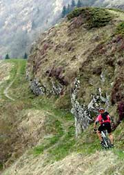
|
| mtb:scale=1 | Smaller obstacles like roots and small stones. Erosion damage may increase difficulty. Soil may be loose in places. Tight turns, but no hairpin turns. Riding requires care and attention, but no special skill. Obstacles can be ridden over. Difficult to ride uphill.
|
<40% | S1 | 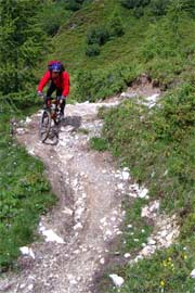
|
| mtb:scale=2 | Obstacles such as large rocks and stones. Soil is often loose. Steps are expected. Wider hairpin turns, steepness of up to 70%. Requires some advanced riding skills. Only very skilled riders can go uphill on this.
|
<70% | S2 | 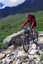
|
| mtb:scale=3 | Many sections with large obstacles such as boulders and large roots. Many hairpin and off-balance turns. Slippery surface and talus sections may be found. The surface may be very slippery. Constant concentration and very good skills needed. Nearly impossible to ride uphill.
|
>70% | S3 | 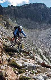
|
| mtb:scale=4 | Very steep and difficult, with sections having large boulders and roots. Frequent loose debris. Very steep sections with very tight hairpin turns and high steps that will cause the chainring to hit the ground. Some trials techniques will be necessary. Nearly impossible to ride uphill.
|
- | S4 | 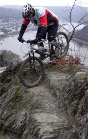
|
| mtb:scale=5 | Very steep and difficult with big boulder fields and debris, and landslides. Speed must be carried for counter-ascents. If at all only short passages are available for accelerating and braking. Fallen trees may make very steep passages even more difficult. Very few Mountainbikers can actually ride at this level. Most will have to push.
|
- | S5 | 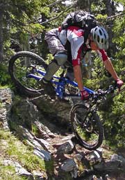
|
mtb:scale:uphill=0-5
In the case you want to be more specific about the difficulty for going uphill
| Tag | Description | Average incline | Maximum incline | Obstacles |
|---|---|---|---|---|
| mtb:scale:uphill=0 | Graveled or haredened earth. Good Grip. Usually a highway=track. Even unskilled mountainbikers can ride up here easily. Cars with good tire clearance can go down or up without problems. | <10% | <15% | None |
| mtb:scale:uphill=1 | Graveled or haredened earth. Good Grip so wheelspin does not happen when taking care. Steep forest track or easy to ride footpath. | <15% | <20% | Some loose objects may lay on the trail but are avoidable |
| mtb:scale:uphill=2 | Mostly stable, unsurfaced, partly washed out, steady pedalling and ballance needed. With good technique and reasonable fitness this should be still doable however. | <20% | <25% | Fistsize loose rocks, roots or rocky underground |
| mtb:scale:uphill=3 | Variable Surface, tight corners, small steps, surface is rocks, earth or gras. Very good ballance and steady, round pedalling needed. Without very good skills mtbikers have to push their bike uphill | <25% | <30% | Fistsize loose rocks, roots and branches or rocky surface |
| mtb:scale:uphill=4 | Way is very steep, or in bad condition for pedalling uphill. Steps, trees, roots and tight corners are present and even good and strong mountainbikers will have to push or carry their bike for parts of the way | <30% | <40% | Big loose rocks, big branches across the trail, rocky or loose surface |
| mtb:scale:uphill=5 | Way is too steep and/or difficult to ride uphill. We need this level for signalling to other mtbikers that on this part they have to push and carry the bike. | - | - | - |
Notes to Usage of the scales
Notes
- "Equivalent to STS" means equivalency to the german Singletrail-Skala v1.4 as found here [1]; upon which this scale is based.
You may also find a more in-depth description of the scale on that page, with more photos (just click on S0 to S5 in the upper bar to get more detailed descriptions and pictures for each level).
- The example photos of the STS scales are from http://www.singletrail-skala.de/ and may be reused under cc-by-sa-2 or cc-by-sa-3.
- If you click on the STS Equivalency links, you are linked to the respective difficulty grades on www.singletrail-skala.de. There are more pictures for each scale to give a better visual impression about each grade.
Usage examples
If only one condition is met, the respecting scale should be used. E.g.
- a way with gradient 50% has to be tagged mtb:scale=2 or higher. Additional to signal to everyone that this way is steep mtb:scale:uphill=5 is needed.
- a way with loose surface possible, small roots and stones that goes flat is still mtb:scale=1 and not lower mtb:scale=0. mtb:scale:uphill is not needed.
- a way with loose surface possible, small roots and stones that goes at an average incline of 25% is mtb:scale=1 and mtb:scale:uphill=3. This is a good example for a way that is quite easy to go down, but very difficult to go up.
mtb:scale:imba=0-4
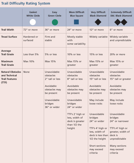
The IMBA Trail Difficulty Rating System shall be used for bikeparks. Especially for North Shore. It is adapted to mtb trails with artificial obstacles. For "natural" trails it is advised to use the mtb:scale/mtb:uphill:scale.
mtb:scale:imba= ... 0 .................... 1 ..................... 2 ..................... 3 ..................... 4 ....
Graphics reused with permission from IMBA.
defaut values
no default is expected, but you can talk about it on the talk page
Deprecates
nothing
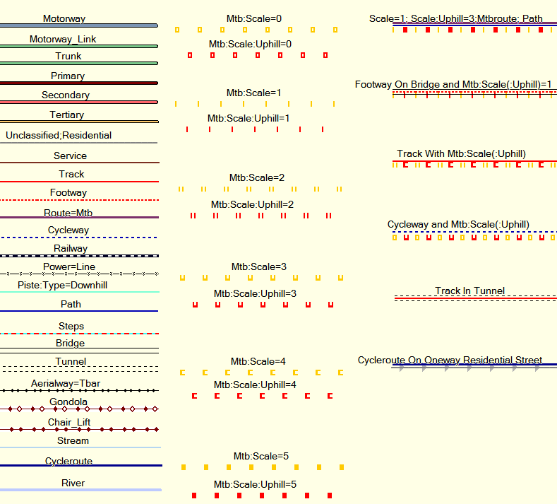
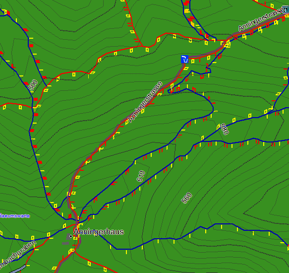
Example Rendering of the mtb:scale using Garmin Mapsource
- If you want to create you maps looking alike follow the process described here: OSM_Map_On_Garmin/mtb_map
- I will try to offer precompiled maps for Garmin Mapsource for the Alps on a server soon, knowing that it's not trivial to setup (once you have it setup nicely it doesn't take much work to update the maps in Mapsource). I will also try to write a Mapnik Rendering style and offer a web server showing a map with all the relevant information for mtbikers, best accessible on Android/Iphone - but that will be in the long run.--Extremecarver 00:44, 27 January 2009 (UTC)
Comments
Moved to discussion page
Voting
I know many people will be frustrated that the voting period is too long, but there have been much concerns on the talk list, that going too fast only leads to frustration, frustration lead to wrath, wrath lead to anger, and anger, as any one knows, leads to the dark side of the force. Sletuffe 13:15, 27 November 2008 (UTC)
 I approve this proposal. : makeing a simple mtb:scale is easier to tag for any one, but if you want to be specific, use mtb:uphill:scale then. I like it like this Sletuffe 13:15, 27 November 2008 (UTC)
 I approve this proposal. --Extremecarver 13:30, 27 November 2008 (UTC)
 I approve this proposal. --The Compiler 14:40, 27 November 2008 (UTC)
 I approve this proposal. --Rad-ab 15:26, 27 November 2008 (UTC)
 I approve this proposal. : although reluctant to mtb:uphill:scale --vibrog 16:39, 27 November 2008 (UTC)
- I don't feel it can do any harm, maybe people will tag mtb:scale only, but for those who wants, it sill possible to make distinction, if the uphill part is completly unused, then, we could deprecate it in some years, or find a better scale Sletuffe 17:32, 27 November 2008 (UTC)
 I approve this proposal. ----Mightym 17:06, 27 November 2008 (UTC)
 I approve this proposal. --Hawke 17:23, 27 November 2008 (UTC)
 I approve this proposal. --Colin Marquardt 19:25, 27 November 2008 (UTC)
 I approve this proposal. --oliver81 06:52, 28 November 2008 (UTC)
 I approve this proposal.--Walley 07:07, 28 November 2008 (UTC)
 I approve this proposal. Pradeepbv 08:33, 28 November 2008 (UTC)pradeepbv
 I oppose this proposal. : I like the idea, but think it needs modification. Daveemtb 08:50, 28 November 2008 (UTC) --> Summary: more scale diffentiation at the bottom. Answer and full objection moved toTalk:Proposed_features/mtb:scale#Voting_objections_1
 I approve this proposal.--dagbj 23:29, 28 November 2008 (UTC)
- I oppose
mtb:scale:uphill=*andmtb:scale=*, but I approvemtb:scale:sts=*andmtb:scale:imba=*. See the talk-page for my reasons! --
Phobie 08:22, 6 December 2008 (UTC)
 I approve this proposal.--Jinx1971 12:38, 17 December 2008 (UTC)
 I approve this proposal. --Meme 05:30, 18 December 2008 (UTC)
 I approve this proposal. --Nop 19:53, 21 December 2008 (UTC)
 I approve this proposal. very good :D --Vincivis 09:21, 31 January 2009 (UTC)
 I approve this proposal. --ck3d 09:23, 31 January 2009 (UTC)
 I approve this proposal. --User:Apo42
 I approve this proposal. Very nice idea. --go2sh 13:07, 12 February 2009 (UTC)
 I approve this proposal. I think this is a clean scale, though I don't see the point in many of the subtags such as
 mtb:scale:uphill=*, but than I am not a mountainbiker. --Skippern 20:27, 17 February 2009 (UTC) I approve this proposal. I'm a mountainbiker and I think this feature is very needed. --Al3xius
Vote Approved: 21Yes over 2 No.
See also
- key:mtb:scale - map Feature Page of the Approved Features mtb:scale.
- Mountain biking - general page on how to tag ways appropriate for Mountainbiking.
