RU:Tag:tunnel=building_passage
 |
| Описание |
|---|
| A tunnel passage that goes though/under a building, but is not inside the building itself. Туннельный проход в здании или под ним. |
| Группа: размещение |
| Используется на элементах |
| Полезные сочетания |
| Статус: одобрено |
| Инструменты |
|
![]()
Вы можете закончить перевод.
Если вы знаете английский, то можете помочь нам, переведя часть оригинальной статьи. Общие сведения о переводе статей на русский язык можно найти здесь.
![]()
Атрибут tunnel=building_passage используется для проходов через здание со стенами с обеих сторон. Они редко бывают не на уровне земли. Это строго туннель, а не путь внутрь здания.
Как обозначить
- The building and the way should have shared nodes at the entry and exit points of the building.
- The way is split at the entry and exit nodes and only the part covered by the building is tagged with tunnel=building_passage.
- The layer should be the same as the layer of the building, with the exception when several tunnels are passing on different levels. So if the building doesn't have a layer tag, the way should not have one either.
- Do not use tunnel=building_passage and covered=yes at the same time.
When not to use
A building passage is a tunnel that goes through a building, but is not inside the building itself (see pictured examples).
For ways that go inside a building, the tags either highway=corridor, or highway=* + indoor=yes can be used.
The walls at both sides (and the top) of the tunnel are considered outer walls of the building, which can have entrances that lead into it. For indoor mapping highway=corridor or indoor=yes can be used.
Many fuel stations (amenity=fuel) have fuel pumps under a roof (building=roof) with no walls. Any service road that goes under the roof is not a building passage. Instead, the roof can be tagged layer=* to indicate that it is above the service road.
It is also not meant for ways that go through something else than a building.
Примеры

Wullersdorf Pfarrhof Durchfahrt

Richard-Matthäi-Haus (Hamburg)
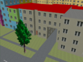
3D model on OSM2World


Рендеринг
