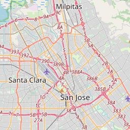
Santa Clara County, California/Cycling routes


|
| CyclOSM A free cycle-oriented map with more features than OpenCycleMap. See its wiki page CyclOSM. |
| Waymarked Trails: Cycling by Sarah Hoffman is a layer superimposed over mapnik (Standard Map Layer) which shows marked cycle routes around the world. Updated minutely, it renders actual routes without the state=proposed tag. Therefore no proposed routes (or proposed numbering protocols) are displayed. |
The Santa Clara Countywide Bicycle Plan (CBP), (June, 2008 version), has a list of bicycle routes and each route's path in Appendix C2, with maps here. This plan updated in May, 2018.
Bicycle plans
| Organization | Info page | Bike Plan | Bicycle Friendly Award |
|---|---|---|---|
| Campbell | BPAC | ? | No |
| Cupertino | BPAC minutes | Bike Plan | Bronze |
| Gilroy | BPC | Bike plan from 2002 | No |
| Los Altos | |||
| Los Gatos | |||
| Milpitas | |||
| Morgan Hill | |||
| Mountain View | |||
| Palo Alto | |||
| San Jose | Bicycling & Walking | Bike Plan 2020 | Bronze |
| Santa Clara | |||
| Saratoga | |||
| Sunnyvale | Bicycle and Pedestrian Advisory Commission | Bike Plan from 2006 | Bronze |
| VTA | bicycle program | Bike plan from 2008 Bike plan from 2018 | N/A |
| Caltrain | BAC | N/A |
Nearly all jurisdictions have adopted and updated bicycle master plans in recent years. As of November 2017, 13 of the 16 Member Agencies have standalone bicycle plans. The agencies without standalone bicycle plans all address bicycle planning in the Transportation Element of their General Plan. See Table 4-A in VTA's 2018 Bike Plan.
VTA's May, 2018 Santa Clara Countywide Bicycle Plan develops "a connected network of approximately 950 miles of Cross County Bicycle Corridors (CCBCs), including ten bicycle superhighways." VTA has identified approximately 350 miles of priority CCBCs (plus the ten potential bicycle superhighway corridors, SHCs). These "candidate corridors for bicycle superhighways" include: Bay Trail, Caltrain / Evelyn/Alma Corridor (on and off street), Guadalupe River and Guadalupe Creek Trails, Stevens Creek/Pruneridge Corridor, Stevens Creek Trail/Union Pacific Railroad Trail, San Tomas Aquino Creek Trail/ Saratoga Creek Trail, Coyote Creek Trail, Branham Corridor (on-street), Blaney / Sunnyvale East Channel Corridor (on and off street) and Three Creeks Trail/Five Wounds Trail. All indicate "SHC" in the "SHC or CCBC?" column in tables below, except for Blaney / Sunnyvale East Channel Corridor and Three Creeks Trail / Five Wounds Trail. These latter two appear to be emerging in OSM: some segments are tagged as bicycle infrastructure, they are newly included in network=lcn relations.
County cycle routes
Numbered routes (lcn)
These are in a relation with network=lcn where members of underlying infrastructure are often bike lanes tagged with cycleway=lane (Class II), though they may also be cycleway=shared_lanes (Class III) or dedicated highway=cycleways (Class I).
As these primarily came from the 2008 Plan and the 2018 plan supersedes that, it is possible some or many of these routes with numbered network=lcn values are obsolete. (It is reported that lcn 11 is extant, with signs on-the-ground). Apparent correct improvements to OSM are to "integrate" newer CCBC and SHC concepts into OSM's data, perhaps or somewhat replacing the routes in this table, as well as documenting (in similar table form) the actual signed on-the-ground routes extant as of 2019 and going forward. This may be helpful: it is an interactive map which when clicked shows the route numbers. Unknown is if those route numbers represent existing routes (as expressed into the network=lcn namespace and cycle_network=US:CA:SC or are "simply route numbers for CCBCs" (which don't fit into OSM's hierarchies in a particular place, but we might find one or make one). This frustrates route harmonizations among tables below. It is acknowledged that the CCBC network "includes segments that don't currently have bikeways and segments that need improvement to provide high-quality, low-stress bicycling." That is sufficient to disqualify such a route from a local cycleway network (in this author's opinion).
However, in very early stages, these appear to be integrating. The newer numbering protocol (extant now, 2019) includes 7 Mary/Old Highway 9 Corridor 10 UPRR Trail 12 South of I-280/Williams/Moorpark/Alma Corridor 14 Blossom Hill Branham to Saratoga Corridor 16 Blossom Hill 24 Blaney/Sunnyvale East Channel Corridor 407 Monterey Highway CCBC, Llagas Trail-Little Llagas Trail to Coyote Lake 411 Coyote Creek Trail CCBC 413 Guadalupe River/Creek Trail/Los Alamitos Trail CCBC 414 Los Gatos Creek Trail CCBC and many others. It seems best to batch these up, consider many things and only upload them to OSM as they are correct and harmonize with existing data. A suggestion is to use old_ref for a while during a transition. Certain spreadsheet construction begins, not much more beyond that. In short, a slow conversion of lcn route numbers may be underway (perhaps towards the 2018 CCBC numbers), that is in its early stages now (June, 2019).
It makes sense to show tables of both. First is the 2008 plan numbering as expressed as lcn routes in OSM, circa early 2010s (to now, 2019; these routes remain in OSM as lcn numbered route relations). Second is an early prototype of Priority CCBCs (NOT exhaustive, early construction).
| Route # (lcn) | Route Name | Description | Mapped | Relation | Analyze | Candidate bicycle superhighway corridor (SHC) or CCBC? |
Notes |
|---|---|---|---|---|---|---|---|
| 01 | Highway 101 Corridor | San Mateo County to San Benito County | 100% | 149407 |
149407 | CCBC except for Scott Blvd. between San Tomas Expy. and Central Expy., E Julian St., 10th/11th Streets and Monterey Hwy. between Tully Road and at least Bailey Avenue | Of 65.26 miles (105.03 km), what is now in OSM goes from Northern SMC boundary to South of Gilroy. If there is actual infrastructure as part of this route south of Gilroy to the SBC boundary, it should be both tagged properly as infrastructure (highway=cycleway, cycleway=lane, cycleway=shared_lane, bicycle=yes...) and added to this relation. |
| 02 | Alma Street/Caltrain Corridor | San Mateo County to Santa Clara | 100% | 1022075 |
1022075 | SHC | |
| 03 | Dumbarton - East-West Connector | North Palo Alto to Los Altos Hills | 100% | 1109585 |
1109585 | ||
| 04 | El Camino Real/ Grand Boulevard Corridor | San Mateo County to Downtown San Jose | 0% | none | Route is planned but no bike lanes yet. Be very careful bicycling on El Camino Real! | ||
| 05A | Shoreline-Miramonte Corridor | Mountain View to Los Altos Hills | 100% | 1027213 |
1027213 | ||
| 05B | El Monte Alignment | Los Altos, Los Altos Hills | 100% | 1205004 |
1205004 | ||
| 05C | San Antonio/Arastradero Alignment | Los Altos, Los Altos Hills | 50% | 1205048 |
1205048 | A large part of the middle stretch of this route is incomplete. Part of the route got cancelled in 2004. | |
| 06 | Tasman/Alum Rock Light Rail corridor | Mountain View to East San Jose | 100% | 1109602 |
1109602 | ||
| 06A | River Oaks Spur | Many gaps in the route list in document | 0% | none | |||
| 07 | Old Highway 9 Corridor | North Sunnyvale to Los Gatos | 90% | 1017450 |
Path around De Anza Community College is incomplete (probably not built yet) | ||
| 08A | Homestead/Hedding/Brokaw Corridor | South Los Altos to San Jose International Airport | 90% | 1015911 |
To do: Track Crossing (may not exist yet need to check) and opposite direction at airport. | ||
| 08B | Park / Penitencia | Santa Clara University to Penitencia Trail | 30% | 2672908 |
|||
| 09 | Wolfe Rd / Borregas Corridor | Sunnyvale to Saratoga | 100% | 1002045 |
|||
| 10 | I-280/Stevens Creek | San Carlos Street Corridor | 90% | 1183076 |
SHC | ||
| 10B | I-280 Corridor - Stevens Creek Boulevard | 100% | 1185185 |
SHC | |||
| 10C | Newer Stevens Canyon Road Route | 100% | 3501676 |
||||
| 11A | Calabazas Creek/Winchester Corridor | Sunnyvale to Los Gatos | 95% | 1185190 |
|||
| 11B | Newer San Jose Route C | Santa Clara to Campbell | 100% | 55971 |
Overlapping route clean up to follow 11B | ||
| 12A | South of 1-280 Corridor | Cupertino to Hillview, east San Jose | 90% | 2672916 |
|||
| 12B | 0% | none | |||||
| 13 | Bowers/Keily/Saratoga Corridor | Northern Santa Clara to Skyline Boulevard | 90% | 56567 |
|||
| 14 | Campbell/Curtner/Tully Corridor | Cupertino/Saratoga to Eastridge | 100% | 1286275 |
|||
| 15 | Valley Fair to Santa Teresa Corridor | Downtown Santa Clara to San Benito County | 0% | none | |||
| 16A | Newer San Jose Route E | 0% | none | ||||
| 16B | Blossom Hill Road Corridor | Saratoga to southeast San Jose | 0% | none | |||
| 17 | I-880/I-680 Corridor | Alameda County to Los Gatos | 100% | 3504754 |
|||
| 18 | San Martin East-West Route | Uvas Road to east side | 0% | none | |||
| 18A | 0% | none | |||||
| 18B | 0% | none | |||||
| 19 | I-880 Corridor | Alameda County to Downtown San Jose | 100% | Convert: 53567 |
|||
| 20 | Coyote Valley/Uvas Reservoir Corridor | South County to SR 152 | 0% | none | |||
| 21 | I-680 Corridor to Silver Creek | Alameda County to South San Jose | 100% | 3504729 |
|||
| 22 | SR 152 Corridor | Santa Cruz County line to Merced County line | 0% | none | |||
| 23 | Eastern South Valley Corridor | Morgan Hill, San Martin, Gilroy | 0% | none | |||
| 24 | Ridge Line Corridor | Los Gatos to Mount Madonna | 0% | none |
And the CCBC planning corridors (these are not, strictly speaking, routes, they are planning corridors totalling about 1000 miles). Again, this table is incomplete and early. No harmonization is taking place right now (2019-Q2), only gathering of data, namely, the identification of CCBSs as they were designated in 2018 and tabling them here. A complete list is appreciated; please complete the table, THEN perhaps we modify OSM lcn route relation data. One method is to leave the existing ref=* alone, another is to migrate it to old_ref=*. We might keep ref=* on routes which have MUTCD M1-8a numbered signs on-the-ground, or those might more properly belong in the table above, meant to depict actual signed routes.
| CCBC # | Route Name | Description | Mapped | Candidate bicycle superhighway corridor (SHC) or CCBC? |
Notes |
|---|---|---|---|---|---|
| 1 | Highway 101? CCBC | San Mateo County to San Benito County | Unknown% | CCBC | |
| 3 | CCBC | No description | Unknown% | CCBC | |
| 6 | N Capitol Avenue CCBC | No description | Unknown% | CCBC | |
| 6 | Tasman/Alum Rock LRC/River Oaks Spur CCBC | Unknown% | CCBC | ||
| 7 | Mary/Old Highway 9 CCBC | Unknown% | CCBC | ||
| 8 | Winchester/Hedding/Berryessa/Penintencia Creek CCBC | Unknown% | CCBC | ||
| 10 | UPRR Trail CCBC | Unknown% | CCBC | ||
| 12 | S of I-280/Williams/Moorpark/Alma CCBC | Unknown% | CCBC | ||
| 14 | Blossom Hill Branham to Saratoga Corridor CCBC (Tully & Ruby East) | Unknown% | CCBC | ||
| 16 | Blossom Hill CCBC | Unknown% | CCBC | ||
| 17 | Oakland Road/Abel/Milpitas Blvd. CCBC | Unknown% | CCBC | ||
| 19 | Dixon Landing/Zanker/Monterey Road CCBC | Unknown% | CCBC | ||
| 24 | Blaney/Sunnyvale East Channel CCBC | Unknown% | CCBC | ||
| 28 | Milpitas Blvd./Lundy/Kink/Silver Creek Road CCBC | Unknown% | CCBC | ||
| 32 | CCBC | Unknown% | CCBC | ||
| 34 | Story/Ruby/Aborn CCBC (to Claton Road East) | Unknown% | CCBC | ||
| 35 | Loma Verde Avenue/Charleston/Arastradero CCBC | Unknown% | CCBC | ||
| 36 | Trade Zone/Cropley CCBC | Unknown% | CCBC | ||
| 407 | Monterey Highway CCBC, Llagas Trail-Little LLagas Trail to Coyote Lake | Unknown% | CCBC | ||
| 407 | CCBC | Unknown% | CCBC | ||
| 409 | SFB Trail CCBC | Unknown% | CCBC | ||
| 410 | CCBC | Unknown% | CCBC | ||
| 411 | Coyote Creek Trail CCBC | Unknown% | CCBC | ||
| 413 | CCBC | Unknown% | CCBC | ||
| 413 | Guadalupe River/Creek Trail/Los Alamitos Trail CCBC | Unknown% | CCBC | ||
| 414 | Los Gatos Creek Trail CCBC | Unknown% | CCBC | ||
| 500 | CCBC | Unknown% | CCBC | ||
| 504 | CCBC | Unknown% | CCBC | ||
| 505 | CCBC | Unknown% | CCBC | ||
| 600 | CCBC | Unknown% | CCBC |
Trails (rcn and lcn)
According to the 2008 CBP, Trail routes are categorized into a hierarchy of three levels. These are:
• Regional Trails (T-R#): that are of national, state, or regional recreation significance and extend beyond the borders of Santa Clara County;
• Sub-Regional Trails (T-S#): that provide regional recreation and transportation benefits by providing continuity between cities and convenient, long-distance trail loop opportunities that link two or more Regional Trails; and
• Connector Trails (T##): that provide convenient means of access from urban areas to the trail network of Regional and Sub-regional Trails or that connect County Parks.
So, "Regional Trails" (T-R#) get network=rcn and "Connector Trails" (T##) get network=lcn. As for "Sub-Regional Trails" (T-S#) being better-tagged with network=rcn or network=lcn, the Guadalupe River Trail (T-S3) was tagged with network=rcn and ref=GRT, due to its length, connectivity to other regional cycleways and proximity to the high-density urban core of Downtown San Jose. This led to all "Sub-Regional Trails" (T-S#) being tagged network=rcn and the following regional conventions:
• the network=rcn namespace is used with a more "regional" naming style on longer, more prominent trails such as "San Francisco Bay" Trail in a form similar to ref=SFB (three-letter acronym), and
• the network=lcn namespace is used with the Santa Clara County numbering protocol on routes of the form ref=T## (but not ref=T-R# and ref=T-S#, as these get "promoted to regional.")
Note that Cycle Map layer allows a maximum of three alphanumeric characters in a ref=* tag, so consider deleting hyphens in routes named T-S# in ref=* tags when these are lcn=*. However, as a three-character acronym from the Trail name is the style for a ref=* tag on regional routes, there is no hyphen to delete, yet we wish to not delete the local protocol route number from OSM, either. This leads to another convention:
• appropriately add tag alt_ref=T-R# or alt_ref=T-S# to "promoted to regional" network=rcn routes. For example, Santa Clara County portions of San Francisco Bay Trail are tagged network=rcn + ref=SFB, yet also contain tag alt_ref=T-R4. This allows OSM tagging to capture Santa Clara County's local protocol route number on a route tagged regional (as the local number does not display in Cycle Map layer).
Many regional trails from the 2008 CBP were in early planning stages. For example, the "de Anza Trail" (dAT) portion was only an initial component of T-R1 (a much longer project) and both Monterey-Yosemite State Trail and Benito-Clara Trail lacked sufficient geographical data to enter into OSM.
| Route # (T## = lcn, T-R#, T-S# = rcn) |
Route Name | Description | Mapped | Map link | Candidate bicycle superhighway corridor (SHC) or CCBC? |
Notes |
|---|---|---|---|---|---|---|
| T01 | Highway 237 Trail/Calaveras Boulevard | Milpitas to Mountain View | 40% | 5336141 |
Entered as lcn T01. Currently stops westbound at Zanker Road | |
| T02 | San Tomas Aquino/Saratoga Creek Trail | Santa Clara, Cupertino, San Jose, Campbell | 100% | 1023172 |
SHC | Entered as lcn T02 |
| T03 | Highway 87 Trail | City of San Jose | 100% | 53029 |
SHC (as Branham Corridor) | Entered as lcn T03 |
| T04 | Uvas Creek Trail | City of Gilroy | 0% | none | ||
| T-R1 | Juan Bautista de Anza National Highway | San Mateo to San Benito County Lines | 10% | 5335186 |
Entered as rcn dAT from Vasona Junction to McClellan Road | |
| T-R2 | Monterey-Yosemite State Trail | TBD | 0% | none | Route not fully planned | |
| T-R3 | Benito-Clara Trail | TBD | 0% | none | Route not fully planned | |
| T-R4 | San Francisco Bay Trail | San Mateo to Alameda County Lines | 50% | 1285802 |
SHC | Entered as rcn SFB independent from other SFB relation 325779 |
| T-R5 | Bay Area Ridge Trail | Alameda to San Benito County Lines | 10% | 5336258 |
Seeded near Penitencia Creek as lcn TR5 (not rcn BAR, this is in early stages and seems more local than regional) | |
| T-S1 | Matadero Creek/Page Mill Trail | Palo Alto, Los Altos Hills, Stanford University | 10% | 5336230 |
Seeded between Foothill Expressway and Deer Creek Road as rcn PMT | |
| T-S2 | Stevens Creek Trail/Union Pacific Railroad Trail | Trail running along creek next to Highway 85 | 100% | 952271 |
SHC | Entered as rcn SCT. Expected to grow further southward. |
| T-S3 | Guadalupe River/Los Alamitos Creek Trail | Alviso, San Jose | 80% | 5322545 |
SHC | Stubbed in as rcn GRT; needs work to complete both sides of creek |
| T-S4 | Los Gatos Creek Trail | San Jose, Campbell, Los Gatos | 100% | 5335571 |
Entered as rcn LGC. Gap between Meridian and Lincoln. | |
| T-S5 | Coyote Creek Trail/Llagas Creek Trail | Milpitas to Coyote Lake, South County | 60% | 3504713 |
SHC | Entered as rcn CCT; gap south of Milpitas needs to be added |
| T-S6 | West Valley Trail | Almaden Lake Park-so. link of Bay Area Ridge Trail | 0% | none | ||
| T-S7 | Morgan Hill Cross-Valley Trail | West Valley Trail to Lake Anderson County Park | 0% | none | ||
| T-S8 | San Martin Cross-Valley Trail | West Valley Trail - Bay area Ridge Trail near Coyote Lake | 0% | none |
Expressways (lcn)
Currently, these are entered as network=lcn though they might be promoted to network=rcn at some point in the future.
| Route # (lcn) | Route Name | Description | Mapped | Map link | Notes |
|---|---|---|---|---|---|
| X-G02 | Lawrence Expressway Route | Saratoga to Sunnyvale | 95% | 1205049 |
connectors to do. |
| X-G03 | Oregon/Page Mill Expressway Route | Los Altos Hills to Palo Alto | 100% | 3501967 |
|
| X-G04 | Montague/San Tomas Expressway | Milpitas to Campbell | 100% | 3501740 |
|
| X-G05 | Foothill Expressway | San Mateo County line, Los Altos, Los Altos Hills, Palo Alto, Cupertino | 90% | 1204994 |
only connectors to do |
| X-G06 | Central Expressway Route | Mountain View to Santa Clara | 100% | 3501976 |
|
| X-G08 | Almaden Expressway Route | City of San Jose | 100% | 3502001 |
|
| X-G21 | Capitol Expressway Route | City of San Jose | 100% | 3502008 |
City cycle routes
All cities in Santa Clara County publish bicycle infrastructure geographic data. Accordingly, OSM strives to tag appropriately on these (California) Class I (highway=cycleway, cycleway=track), Class II (cycleway=lane) or Class III (a bicycle path or route, either cycleway=shared_lane or bicycle=yes) ways. However, as of 2018, of all cities in Santa Clara County, only the City of Sunnyvale crafts these bicycle-tagged infrastructure elements into distinct bicycle routes in the numbered local cycleway network (network=lcn), doing so with three-digit route numbers. A corollary appears to be that two-digit network=lcn values get assigned by the County of Santa Clara and that three-digit network=lcn values get assigned by incorporated cities within the County of Santa Clara.
Sunnyvale Cycle Routes (lcn)
| Route # (lcn) | Route | Description | Mapped | Map link | Notes |
|---|---|---|---|---|---|
| 352 | Murphy Square/Caltrain Station to La Conner | Moffett Business Park - De Anza | 100% | 8374486 |
|
| 353 | WPCP to Murphy Square/Caltrain Station | Moffett Business Park - Ortega/De Anza | 100% | 8374485 |
|
| 600 | South Bernardo (Mountain View) to Poinciana (Santa Clara) | West City - Ponderosa | 100% | 8374484 |
|
| JWC | Orchard Park - North Fair Oaks - Mission College | John W. Christian Greenbelt | 100% | 60198 |
Does anybody know if this is a City of Sunnyvale "sponsored" route, and if so (or not) does it have an actual (three-digit) route number, instead of "JWC"? |