Tag:railway=crossing: Difference between revisions
Jump to navigation
Jump to search
(added seeAlso) |
(update) |
||
| Line 15: | Line 15: | ||
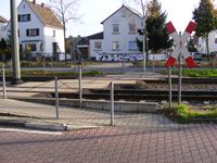
A point where pedestrians may cross a railway. |
A point where pedestrians may cross a railway. |
||
== Tags to use in combination == |
|||
* {{Tag|crossing}} for usage. |
|||
** {{Tag|crossing||traffic_signals}} |
|||
** {{Tag|crossing||uncontrolled}} |
|||
* {{Tag|crossing:barrier||yes}} |
|||
* {{Tag|crossing:light||yes/no}} |
|||
* {{Tag|supervised|yes}} |
|||
== Possible Rendering == |
== Possible Rendering == |
||
| Line 22: | Line 28: | ||
== See also == |
== See also == |
||
* {{Tag|railway|level_crossing}} - ''a point where a road crosses a railway'' |
* {{Tag|railway|level_crossing}} - ''a point where a road crosses a railway'' |
||
* {{Tag|highway|crossing}} - A point where pedestrians may cross a highway. |
|||
[[Category:Railway tags in English]] |
[[Category:Railway tags in English]] |
||
Revision as of 06:51, 20 March 2016
| Description |
|---|
| Pedestrians can cross a railway here |
| Rendering in OSM Carto |
| Group: crossings |
| Used on these elements |
| Useful combination |
|
| See also |
| Status: in use |
| Tools for this tag |
|
A point where pedestrians may cross a railway.
Tags to use in combination
- crossing=* for usage.
- crossing:barrier=yes
- crossing:light=yes/no
- supervised=yes
Possible Rendering
![]() (logo suggested by User:Chrisana13)
(logo suggested by User:Chrisana13)
See also
- railway=level_crossing - a point where a road crosses a railway
- highway=crossing - A point where pedestrians may cross a highway.
