Tag:highway=chemin_de_ronde
 |
| Description |
|---|
| A chemin de ronde was devised as a walkway allowing guards and defenders to patrol the tops of ramparts, protected from the outside by the battlements or a parapet. |
| Group: highways |
| Used on these elements |
| Requires |
| Implies |
| Useful combination |
|
bridge=yes |
| See also |
| Status: proposed |
| Tools for this tag |
|
Use highway=chemin_de_ronde to represent a ![]() chemin de ronde (is French for "round path"' or "patrol path", also known as an "allure", "alure", a "wall-walk", "guard-walk") for traversing a city walls or castle and fortress walls. This path is a raised protected walkway behind a wall=castle_wall, historic=citywalls, barrier=city_wall
chemin de ronde (is French for "round path"' or "patrol path", also known as an "allure", "alure", a "wall-walk", "guard-walk") for traversing a city walls or castle and fortress walls. This path is a raised protected walkway behind a wall=castle_wall, historic=citywalls, barrier=city_wall ![]() battlement or simple
battlement or simple ![]() parapet.
Today, it is a feature of medieval fortifications of high tourist interest.
There could be overlap between chemin de ronde and highway=path or footway.
parapet.
Today, it is a feature of medieval fortifications of high tourist interest.
There could be overlap between chemin de ronde and highway=path or footway.
How to map
Draw a way and tag it with highway=chemin de ronde. Accesses could be drawn and tagged as a stairs, entrance, directly or via towers (fortified tower or city gate).
Add highway=chemin de ronde and details along the way such as:
in combination with:
- bridge=yes
- wheelchair=*
- bicycle=*
Tag implies unsuitability for horse=* and vehicle=*.
In this case highway=path may also be used as main tag, depending on which use is prevalent.
Details along the way
Tags have to be added to portion of the way that designates access such as ladder=yes, stairs=yes and entrance="doors".
Examples

Stairs to chemin de ronde along the
 Walls of Dubrovnik
 Great wall of Chine - very long chemin de ronde

Chemin de ronde along the
Walls of Ston, longest in Europe.
Chemin de ronde along the
Jajce Citadel walls

Castell de l'Aïnsa

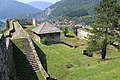
Chemin de ronde (camminamenti di ronda in Italian) Castello Bardi

Castelo de Numão, Portugal

Chemin de ronde in Brouage
.jpg)
.jpg)


_-_camminamenti_di_ronda_2_2023-07-04.jpg)
.jpg)

See also
- climbing=* - mapping of climbing routes
- assisted_trail=*