Climbing

|
| Description |
| Climbing and related features |
| Group |
| Tags |
|
|
A set of tags to describe climbing facilities, routes, and crags.
Climbing sites
The main climbing sites are marked with `area` and `crag` relations (see below).
Natural or man made elements, representing the climbing sites on the ground, can be marked with sport=climbing. This applies to:
 nodes, for artificial climbing walls, crags (if no further information available)
 ways, in conjunction with
 natural=cliff areas, for climbing halls with
 building=*- boulders attached to bedrock (
natural=rock) and free standing boulders (natural=stone).
Basic tags
The most important, basic tags to describe a climbing site:
| Tag | Description |
|---|---|
sport=climbing
|
Climbing is possible here. |
name=*
|
Name of the crag/climbing hall/boulder, if applicable. |
leisure=pitch
|
 man_made=tower and tower:type=climbing.Sometimes, this is also tagged as a leisure=sports_centre, but this goes against the definition of a leisure=sports_centre as a significant facility.
|
leisure=sports_centre
|
Significant artificial climbing facility, indoor (in combination with building=*) or outdoor.
|
leisure=sports_hall
|
Climbing gyms smaller than sports centre. |
natural=cliff
|
Outdoor climbing on a cliff. |
natural=rock/natural=stone
|
Outdoor climbing on a single bedrock-attached rock or free-standing stone. |
Note that the sport=climbing tag must be present in the relations listed below.
Climbing areas
All of the crags within a climbing area are grouped into a site relation of type climbing and tagged with climbing=area. Areas can be nested within parent areas, providing a convenient way to group crags, sectors, and smaller areas into bigger ones. It is suggested to create only areas with commonly used names (grouping areas only by geograpy is not recommended, because maintenance would be too difficult).
To optionally add additional information about the area, such as the climbing styles, see the Climbing styles, Grading, and Additional information sections.
| Key | Value | Comment |
|---|---|---|
type
|
site
|
A site relation is used to group several objects which together have a single identity as a whole but cannot be accurately described by other data types. |
climbing |
area |
A region with numerous climbing routes. |
name |
* | Name of the area |
| sport | climbing |
Crags
All of the routes within a crag are grouped into a site relation of type climbing and tagged with climbing=crag.
To optionally add additional information about the crag, such as the climbing styles, see the Climbing styles, Grading, and Additional information sections.
You can add other objects to the relation (parking, cliff, peak, shelter etc.) – the renderers should treat as routes only members tagged with climbing=route or climbing=route_bottom. No special role needed for that.
| Key | Value | Comment |
|---|---|---|
type
|
site
|
A site relation is used to group several objects which together have a single identity as a whole but cannot be accurately described by other data types. |
climbing |
crag |
A small area with climbing routes, often just a small cliff face or a few boulders. |
name |
* | Name of the crag |
| sport | climbing |
Climbing gyms
These are indoor locations intended for climbing: Bouldering gym, climbing center, climbing hall etc. Some may have also an outdoor wall. Often entry fee.
| Key | Value | Comment |
|---|---|---|
building
|
*
|
A building representing the physical structure. |
sport
|
climbing
|
|
name
|
*
|
Name of the gym |
Boulders
Boulders are small rocks that have "problems" instead of routes. Sometimes they can be climbed with less protection than other areas to practice moves. There are two possibilities to map them:
A free-standing rock with a single "route" could be mapped as, e.g., natural=stone + sport=climbing +
| Key | Value | Element | Comment |
|---|---|---|---|
climbing |
boulder |
This is a boulder | |
name |
* | Name of the boulder |
Crags or sites with more routes can be mapped as site or crag in combination with climbing:boulder=yes.
Climbing routes
Climbing routes can be mapped with 1) a single node marking the bottom of the route, tagged as climbing=route_bottom, or 2) as a way tagged asclimbing=route with start node tagged as climbing=route_bottom and end/anchor tagged as climbing=route_top.
Since climbing routes are generally quite vertical, the start and end nodes may be almost on top of each other. The rationale behind allowing way, even though they may be extremely close on the map, is to allow a path connecting to the bottom of the route (think approach/ascent) to be differentiated from a path connecting to the top (think descent via path). As such, if there is no top-access to the route, only a single node, marking the start, is probably preferable - see discussion.
If the climbing route is more or less horizontal or doesn't have a clear top/bottom it may be mapped only with a way or node climbing=route.
| Key | Value | Element | Comment |
|---|---|---|---|
name |
* | Name of the route. | |
climbing |
route_bottom |
This is the bottom of a climbing route. | |
climbing |
bolt |
This is a point of protection permanently installed in a hole drilled into the rock, to which a metal hanger is attached, with a hole for a carabiner or ring. | |
climbing |
route_top |
This is the top of a climbing route. | |
climbing |
route |
This is the route itself (but see the note above). | |
climbing:bolts |
<number> | The amount of bolts in the route (indicates how much gear you have to take). | |
climbing:length |
* | The length of the route (in metres). | |
climbing:pitches |
* | How many pitches make up the route (defaults to 1). | |
climbing:inclination:vertical |
yes / no |
A straight-up vertical wall (90° or nearly so). | |
climbing:inclination:slab |
yes / no |
A wall that leans back (<90°), requiring balance and technique. | |
climbing:inclination:overhang |
yes / no |
A wall that leans outward (>90°), requiring strength and power. | |
climbing:inclination:roof |
yes / no |
A horizontal ceiling or near-horizontal section. | |
climbing:inclination:traverse |
yes / no |
A route with significant horizontal movement (sideways climbing). | |
climbing:hazard:loose_rock |
yes / no |
There are unstable rocks that may shift or break when weighted. | |
climbing:hazard:rockfall_zone |
yes / no |
This route or section lies in an area prone to falling rocks from above. | |
climbing:hazard:wet |
yes / no |
This section is often wet or slippery, even in dry weather. | |
climbing:hazard:vegetation |
yes / no |
Vegetation (e.g. moss, bushes) interferes with climbing or obscures holds. | |
climbing:hazard:missing_anchor |
yes / no |
The route is missing a belay, top-out, or rappel anchor; climbers must improvise or bring gear for natural protection. | |
climbing:hazard:unstable_anchor |
yes / no |
A belay or rappel anchor is in poor condition or insecure. | |
climbing:hazard:animal_nest |
yes / no |
Birds, bees, or other wildlife may be present and pose a risk. | |
climbing:hazard:death_fall_zone |
yes / no |
A fall in this section would have a very high consequence, such as hitting a ledge or the ground. | |
climbing:hazard:first_bolt_high |
yes / no / <number in meters> |
The first bolt is unusually high, which may increase the risk of ground fall before clipping it. | |
climbing:hazard:long_runout |
yes / no / <max runout in meters> |
The spacing between protection points is large, which may lead to long falls or increased risk between bolts. | |
climbing:hazard:bad_protection |
yes / no |
The available fixed gear is outdated, rusty, or otherwise unreliable. | |
climbing:hazard:dirty_rock |
yes / no |
The rock surface is dusty, muddy, or otherwise dirty, which may reduce grip or safety. | |
climbing:hazard:slippery_rock |
yes / no |
The rock surface is worn smooth and slippery, often due to frequent traffic, especially on limestone. | |
climbing:family_friendly |
yes / no |
The climbing area is safe and suitable for families with children (easy access, safe terrain, space to play). |
Multi-pitch
Multi-pitch routes can be mapped in two ways.
- If they are a continuous route (way), they can simply be added as a
climbing=routewithclimbing:pitches=*tag showing the number of pitches on the route. - Each stage/pitch of a multi-pitch route can be mapped as a climbing route (way). A relation that represents the whole route can include all of them together. There could also be a
highway=pathconnecting the climbing routes. These sections can also be added to the relation. The route relation would have the name of the route.
The route can be added to a crag or a site.
Climbing styles
Tags for multiple climbing styles can be combined and more tags can be invented as needed, the list of wikipedia:Climbing serves as first indication. If any of those tags is not stated explicitly, it defaults to no.
Can be applied to single routes, boulders, crags or general climbing sites.
limited means that there aren't many routes in this style so it's not really a place you'd go for for that style specifically. Especially used in the context of gyms.
| Tag | Value | Description |
|---|---|---|
climbing:boulder
|
yes / no / limited / <amount of routes> / <climbing surface> m²
|
Bouldering is possible. |
climbing:sport
|
yes / no / limited / <amount of routes>
|
Sport climbing (relies on permanent, fixed anchors) is possible. In the context of gyms: lead climbing. |
climbing:speed
|
yes / no / <amount of routes>
|
Speed climbing Facility has a standardized speed climbing wall. |
climbing:toprope
|
yes / no / limited / <amount of routes>
|
Top rope climbing (approach at the route top and letting the rope down) is possible. Fixed or natural anchors may be placed at the top, but routes may not have protection for leading. In the context of gyms: top ropes are provided, permanently hanging from the wall every few metres. |
climbing:trad
|
yes / no / <amount of routes>
|
Traditional climbing (no fixed anchors, gear has to be placed by yourself) is possible. Cannot be expressed by climbing:bolted=no if a climbing site also offers sport climbing.
|
climbing:multipitch
|
yes / no / <amount of routes>
|
There are multi-pitch routes. |
climbing:ice
|
yes / no / <amount of routes>
|
Icefalls or the like enable ice climbing. In contrast to mixed climbing, no rock climbing is involved here. |
climbing:mixed
|
yes / no / <amount of routes>
|
Mixed climbing on partially iced rocks is possible. |
climbing:deepwater
|
yes / no / <amount of routes>
|
Steep cliffs with deep enough water below permit deep-water soloing. |
Grading
Can be applied to single routes, boulders, crags or general climbing sites.
When used for crags or regions, we have to specify a difficulty, aid or danger range from easiest to most difficult route. The main character of a climbing area is tagged using mean.
Numerous grading systems exist. Map the usual one(s) for the climbing spot, i.e. commonly used ones - grades in other systems can be derived by conversion. In this tagging scheme, you can use any system by deriving the key from the system's name or acronym similar to the following examples.
| Tag | Description |
|---|---|
climbing:grade:uiaa=*
|
Grade according to the UIAA grading system, e.g. 1-, 1, 1+, 2-, 2, etc.
UIAA grades are used in some parts of central and eastern Europe. The UIAA system is sanctioned by the International Climbing and Mountaineering Federation. |
| Minimum/maximum/average grade according to the UIAA grading system, e.g. 1-, 1, 1+, 2-, 2, etc. | |
climbing:grade:french=*
|
Grade according to the French grading system, e.g. 4, 5a, 5b, etc. Here, we do not distinguish between bouldering (FB) and climbing.
French grades are widespread even outside France. |
| Minimum/maximum/average grade according to the French grading system, e.g. 4, 5a, 5b, etc. Here, we do not distinguish between bouldering (FB) and climbing. | |
climbing:grade:saxon=*
|
Grade according to the Saxon grading system, e.g. VI, VIIa, VIIb, etc, predominantly used in the Saxon Switzerland, Germany |
| Minimum/maximum/average grade according to the Saxon grading system, e.g. VI, VIIa, VIIb etc, predominantly used in the Saxon Switzerland, Germany | |
climbing:grade:aid=*
|
A0 to A5 for aid routes (DE: Technisches Klettern) |
climbing:grade:hueco=*
|
V-scale used with bouldering in the United States; e.g. V0, V1, V2, etc. |
climbing:grade:yds_class=*
|
Yosemite Decimal System class, e.g. 5.7, 5.10a, 5.12d, etc. |
climbing:grade:ice=*
|
Waterfall ice climbing, e.g. WI2, WI3+, etc. |
climbing:grade:norwegian=*
|
Nordic grading system. |
climbing:grade:british_traditional=*
|
The British grading system for traditional climbs. |
climbing:grade:british_adjectival=*
|
The Adjectival English Scale or the overall assessment scale. |
climbing:grade:polish=*
|
Polish grading system. |
| ... | ... |
Grading conversion chart
The following conversion chart can be used for approximate conversion between different grading systems. This information can also be found in a CSV format here:
- ClimbTheWorld-Android's grading_system_conversion.csv (updated 2022)
- openclimbing.org's gradeData.ts (updated 2025). Climbing grade table in human readable format is here: https://openclimbing.org/climbing-grades
| UIAA, Germany | UK Tech | UK ADJ | FB, French British | French | Saxon, Swiss | Nordic, Scandinavian | YDS, YDS_class | V Grade | WI | Mixed |
|---|---|---|---|---|---|---|---|---|---|---|
| System used by the International Climbing and Mountaineering Federation. | The British grading system for traditional climbs. | The Adjectival English Scale or the overall assessment scale. | Sport climbing in Britain and Ireland uses the French grading system. | The French numerical system (Fontainebleau Scale) rates a climb according to the overall technical difficulty and strenuousness of the route. | The Saxon grading system was developed in the beginning of the 20th century for the formidable Saxon Switzerland climbing region. | The Nordic grading system. | The Yosemite Decimal System of grading routes of hikes and climbs developed for the Sierra Nevada range. | V scale grading system, created by John Sherman, is the most widely used system in North America for bouldering. | Waterfall ice rating system as used in the Canadian Rockies. | Mixed climbing has its own grading scale that roughly follows the WI rating system. |
climbing:grade:
|
climbing:grade:
|
climbing:grade:
|
climbing:grade:
|
climbing:grade:
|
climbing:grade:
|
climbing:grade:
|
climbing:grade:
|
climbing:grade:
|
climbing:grade:
|
climbing:grade:
|
| 1- | 1 | M | 1 | 1 | I | 1 | 5 | VB- | WI2 | M2 |
| 1 | 1 | M | 1 | 1 | I | 1 | 5 | VB- | WI2 | M2 |
| 1+ | 1 | M | 1 | 1 | I | 1 | 5 | VB- | WI2 | M2 |
| 2- | 2 | M/D | 1 | 2 | II | 1 | 5.1 | VB- | WI2 | M2 |
| 2 | 2 | M/D | 1 | 2 | II | 1 | 5.1 | VB- | WI2 | M2 |
| 2+ | 2 | M/D | 1 | 2 | II | 1 | 5.2 | VB- | WI2 | M2 |
| 3- | 3 | D | 1/2 | 3 | III | 1/2 | 5.2 | VB- | WI2 | M2 |
| 3 | 3 | D | 1/2 | 3 | III | 1/2 | 5.3 | VB- | WI3 | M3 |
| 3+ | 3 | D | 1/2 | 3 | III | 1/2 | 5.3 | VB- | WI3 | M3 |
| 4- | 4a | D/VD | 2 | 4 | IV | 2 | 5.4 | VB- | WI3 | M3 |
| 4 | 4a | D/VD | 2 | 4 | IV | 2 | 5.5 | VB- | WI3 | M3 |
| 4+ | 4a | VD | 2 | 4+ | IV/V | 2 | 5.6 | VB- | WI3 | M3 |
| 5- | 4a/4b | S | 2/3 | 5a | V | 2/3 | 5.7 | VB-/VB | WI3 | M3 |
| 5 | 4b | HS | 3 | 5a/5b | VI | 3 | 5.8 | VB | WI4 | M4 |
| 5+ | 4c | HS/VS | 4a | 5b | VI/VIIa | 4a | 5.9 | VB/V0- | WI5 | M5 |
| 6- | 4c/5a | VS | 4a/4b | 5b/5c | VIIa | 4a/4b | 5.10a | V0- | WI6 | M6 |
| 6 | 5a | HVS | 4b | 5c | VIIb | 4b | 5.10b | V0-/V0 | WI6 | M6 |
| 6+ | 5a/5b | E1 | 4c | 6a | VIIc | 4c | 5.10c | V0 | WI6 | M6 |
| 7- | 5b | E1/E2 | 5a | 6a+ | VIIIa | 5a | 5.10d | V0+ | WI6 | M6 |
| 7 | 5b/5c | E2 | 5b | 6b | VIIIb | 5b | 5.11a | V1 | WI7 | M7 |
| 7+ | 5c | E2/E3 | 5c | 6b+ | VIIIc | 5c | 5.11b | V1/V2 | WI7 | M7 |
| 8- | 5c/6a | E3 | 6a | 6c | IXa | 6a | 5.11c | V2 | WI8 | M8 |
| 8 | 6a | E4 | 6b | 7a | IXb | 6b | 5.11d | V3 | WI8 | M8 |
| 8+ | 6a | E4/E5 | 6b+ | 7a+ | IXc | 6b+ | 5.12a | V3/V4 | WI8 | M8 |
| 9- | 6b | E5 | 6c | 7b+ | Xa | 6c | 5.12b | V4 | WI8 | M8 |
| 9 | 6b/6c | E6 | 6c+ | 7c | Xb | 6c+ | 5.12c | V4/V5 | WI9 | M9 |
| 9+ | 6c | E6/E7 | 7a | 7c+ | Xc | 7a | 5.12d | V5 | WI9 | M9 |
| 10- | 6c | E7 | 7a+ | 8a | Xc | 7a+ | 5.13a | V6 | WI9 | M9 |
| 10 | 6c/7a | E7/E8 | 7a+/7b | 8a/8a+ | Xc/XIa | 7a+/7b | 5.13b | V6/V7 | WI9 | M9 |
| 10+ | 7a | E8 | 7b | 8a+ | XIa | 7b | 5.13c | V7 | WI10 | M10 |
| 11- | 7a | E9 | 7b+ | 8b | XIb | 7b+ | 5.13d | V8 | WI10 | M10 |
| 11 | 7a/7b | E9/E10 | 7c | 8b+ | XIc | 7c | 5.14a | V9 | WI10 | M10 |
| 11+ | 7b | E10 | 7c+ | 8c | XIc/XIIa | 7c+ | 5.14b | V10 | WI10 | M10 |
| 12- | 7b | E11 | 7c+/8a | 8c+ | XIIa | 7c+/8a | 5.14c | V10/V11 | WI11 | M11 |
| 12 | 7b | E11 | 8a | 9a | XIIb | 8a | 5.14d | V11 | WI11 | M11 |
| 12+ | >7b | >E11 | 8a+/8b | 9a+ | XIIb/XIIc | 8a+/8b | 5.15a | V12 | WI11 | M11 |
| 13- | >7b | >E11 | 8b | 9a+/9b | XIIc | 8b | 5.15a | V13 | WI11 | M11 |
| 13 | >7b | >E11 | 8b+ | 9b | XIIc | 8b+ | 5.15b | V14 | WI12 | M12 |
| 13+ | >7b | >E11 | 8c | 9b+ | >XIIc | 8c | 5.15c | V15 | WI13 | M13 |
| 14- | >7b | >E11 | 8c+ | 9c | >XIIc | 8c+ | 5.15d | V15 | WI13 | M13 |
Climbing table for bouldering
| American V-Grade |
French Font Grade |
|---|---|
| VB− | 2 |
| VB | 3 |
| V0− | 4− |
| V0 | 4 |
| V0+ | 4+ |
| V1 | 5 |
| V2 | 5+ |
| V3 | 6A |
| 6A+ | |
| V4 | 6B |
| 6B+ | |
| V5 | 6C |
| 6C+ | |
| V6 | 7A |
| V7 | 7A+ |
| V8 | 7B |
| 7B+ | |
| V9 | 7C |
| V10 | 7C+ |
| V11 | 8A |
| V12 | 8A+ |
| V13 | 8B |
| V14 | 8B+ |
| V15 | 8C |
| V16 | 8C+ |
| V17 | 9A |
| V18 | 9A+ |
Additional information
Most of this can be applied to single routes, boulders, crags or general climbing sites, for some details climbing routes have more options - see the section about climbing routes.
| Key | Value | Description |
|---|---|---|
climbing:bolt
|
abseil / anchor
|
Is the bolt designed for abseiling / fixed anchors? Abseiling points can also be mapped as separate points to allow easier location. |
climbing:bolts
|
yes / no / <amount of bolts>
|
Are there fixed anchors? If so, how many bolts are there? How much gear is needed? |
climbing:bolted
|
yes / no / <average bolt distance in meters>
|
Are there fixed anchors? If so, what is their average distance (by default in meter, other units possible)? Provides a first indication of how well the routes are secured. |
| Average, minimum and maximum length of routes in meters (for other units refer to units overview).
May significantly differ from wall height for roofs or slanted walls. This values is important for deciding, which rope to take. | ||
|
|
yes / no / limited / <amount of routes> / <climbing surface> m²
|
Mainly for artificial walls, indicate whether given climbing style (i.e. sport, toprope, speed or boulder) is indoor or outdoor and how big it is. limited means that there aren't many routes in this style so it's not really a place you'd go for when looking for indoors/outdoors routes in that style specifically.
|
climbing:orientation
|
|
Orientation of the rock/wall face. Helps to assess at what hour of the day it might be sunny and how long it takes a wall to get dry after rain. If the cliffs are also mapped as |
climbing:quality
|
|
Quality of the rock/ice. |
climbing:rock
|
|
For rock climbing this tag describes the kind of rock available. This information is irrelevant for e.g. ice climbing. |
climbing:routes
|
<amount of routes> | Amount of routes on this crag (if not tagged in the climbing styles). |
climbing:summit_log
|
yes / no
|
The climbing feature has a route / summit log (summit register, de:Gipfelbuch). This tag is clearer in describing the purpose than summit:register=yes.
|
ele
|
When used with the general climbing site average elevation (height above sea level) at the bottom of the routes in meters. This is not the length of a route or the elevation of the route's top end. When used on other nodes specific to the marked point. | |
| height | <height in meters> | Height of the cliff, route etc. |
| direction | N, NW etc. | If a cliff/crag/route has a clear aspect |
indoor
|
yes / no
|
Artificial climbing structures can have routes indoor, outdoor or both. Natural climbs may be placed inside caves. In the absence of these tags, outdoor-only should be assumed as default. |
website
|
URL | Official website, e.g. operator |
url
|
URL | Unofficial website with useful information like topos |
wikimedia_commons
|
File Path | Photograph of the route, cliff, crag, or area |
wikimedia_commons:path
|
X,Y coordinates in related wikimedia image <0; 1> separated by |. E.g: 0.682,0.823|0.642,0.453|0.557,0.177
|
Draws a line over specified wikimedia_commons=* image. More info here. Designed for drawing climbing routes. Examples here.
|
climbing:url:openbeta
|
URL | Link to the OpenBeta webpage for the route, cliff, crag, or area |
climbing:url:mountainproject
|
URL | Link to the Mountain Project webpage for the route, cliff, crag, or area |
climbing:url:thecrag
|
URL | Link to the theCrag webpage for the route, cliff, crag, or area |
climbing:url:sendage
|
URL | Link to the Sendage Climbing website for the route, cliff, crag, or area |
climbing:url:ukclimbing
|
URL | Link to the UKClimbing webpage for the route, cliff, crag, or area |
climbing:url:toplogger
|
https://app.toplogger.nu/<name of gym>
|
URL of the toplogger.nu webpage for the gym. Strip the language code and the trailing "/boulders" or "/routes" from the URL. |
opening_hours
|
|
Artificial walls often have fixed opening hours. For rocks there might be restrictions due to breeding birds, etc. |
fee
|
yes / no / donation
|
Artificial walls or climbing halls may charge an entrance fee. |
membership
|
required / no
|
Natural climbing sites may require a membership of an alpine club. |
climbing:restriction
|
yes / partly / no
|
Indicates restrictions to climbing, imposed by some local authority |
climbing:restriction:time_description
|
* | Description when climbing is restricted |
climbing:kids
|
yes / limited / no
|
Indicates if the climbing gym provides (some) climbing routes for kids |
kids_area
|
yes / no
|
Indicates if the climbing gym has a dedicated, separated and signposted area for kids to climb |
Approach
The tag path=climbing_access should be used for paths dedicated to access climbing crags, not for general hiking.
Tag approach paths using access=destination within nature reserves etc. where leaving of hiking paths is forbidden.[1]
Descent
Some abseil/rappel routes have been tagged with climbing=abseil_route.
Climbing gym services and facilities
| Key | Value | Description |
|---|---|---|
service:climbing_shoes:rental
|
yes / no
|
Can a pair of climbing shoes be rented here for use within the gym? Also consider one of these:
|
service:climbing_harness:rental
|
yes / no
|
Can a harness be rented here for use within the gym? Also consider one of these:
|
service:climbing_belay_device:rental
|
yes / no
|
Can a belay device be rented here for use within the gym? Also consider one of these:
|
service:climbing_rope:rental
|
yes / no
|
Can a rope for lead climbing be rented here for use within the gym? Also consider one of these:
|
service:climbing_chalk_bag:rental
|
yes / no
|
Can a chalk bag be rented here for use within the gym? Also consider one of these:
|
climbing:autobelay:toprope
|
yes / no / all / only / <amount of auto belay devices (not counting those only for speed)>
|
Are there auto belays for top rope routes? (Not counting those used exclusively for speed climbing.)
|
climbing:autobelay:sport
|
yes / no / all / <amount of auto belay devices>
|
Are there auto belays for lead routes?
|
Pictogram examples
-
 An icon for Rock/Sports climbing and bouldering
 -
 An icon for Rock/Sports climbing
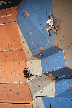
Photo examples
-
 Boulder Bridge area at Morialta, Australia
 -
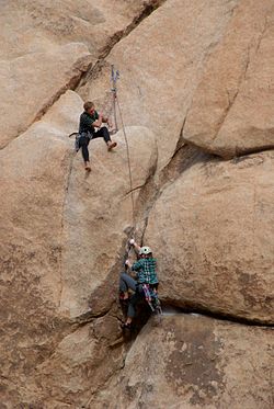 5.10b route on The Sentinel Rock at The Real Hidden Valey, Joshua Tree National Park USA
 -
 Kamar Zard Buzhan - Hiker - Nishapur
 -
 Climber on Stem Gem a classic V4 boulder problem in Joshua Tree National Park in Hidden Valley Campground
 -
-
 Climbing in Saxon Switzerland
 -
 Indoor climbing
 -
 Climbing tower in Berlin-Spandau


Renderer and applications


Like other specialised sports, these tags are not rendered in the standard OpenCarto style. Therefore, these engines visualise them:
- openclimbing.org (app)
- Live OSM data + tool for creating interactive topos (marking lines, bolts, anchors, etc.)
- Using public databases only - OSM for data and Wikimedia commons for images
- Mobile app as PWA
- Topo example 1, Topo example 2
- OsmAnd v5.0+
- OpenClimbingMap
- Live data through Overpass-API; only for zoom levels 12 and up
- Leaflet Sport Climbing Map Example 1 (sport=climbing) and Example 2 (climbing:sport=*)
- Manually synced data; current data: 11-05-2014; all zoom levels
- OpenBeta
- Manually synced data as of April-18-2017. Auto-sync Draft proposal
- Climb The World
- Web app and Android app that will display climbing places and routes.
- Uses overpass-API to display climbing locations.
- MapComplete climbing map
- OsmAnd
- Can display
sport=climbingtags if "Climbing" is selected under "POI overlay". (This does not include routes tagged only with, for instance,climbing=route_bottom, though.)
- Can display
The following renderer displays these tags
Related tags
Map features
natural=bare_rocknatural=cliffnatural=stonenatural=screenatural=glacierhighway=pathsac_scale=*playground=climbingwalldescribes a small wall for children to climb on it on playgrounds
 path=climbing_access for paths dedicated to access climbing crags, not for general hiking.
- sport=climbing_adventure exists in the wiki and is said to be a special way of organizing climbing in a dedicated man-made facility or built outdoors.
Proposals
Proposed features where we could share ideas and maybe re-use common tags:
- Proposed features/Climbing source for most of the content on this page
- via ferrata proposal, now with a ferrata relation that may also include climbing sections
- Proposed features/high rope course
- See also the German version of
sport=climbing- it contains a JOSM tagging preset and the nucleus of a proposal aiming to map climbing sites like climbing areas, sectors, crags/boulders/... and of course halls - OpenBeta Initiative workflow proposal would link climbing information on OpenStreetMap to another open database, containing detailed climbing-specific information
Statistics
The tags are in active use - see https://taginfo.openstreetmap.org/search?q=climbing#keys
pangoSE estimate that, as of September 2018, at least 14000 real world climbing sites exist (estimated from sport=climbing and leisure=climbing) and out of these 10-20% are mapped more detailed with the more detailed keys.
climbing=*: