Vietnam Mapping Guide

This page is adapted from User:Koreller's excellent North Korea Mapping Guide. Though after the ![]() Đổi Mới reforms in 1986, Vietnam has become significantly richer, more accessible and less dystopian than North Korea, so a separate mapping guide is necessary...
Đổi Mới reforms in 1986, Vietnam has become significantly richer, more accessible and less dystopian than North Korea, so a separate mapping guide is necessary...
Foreword and tips
Armchair mapping in Vietnam is a big pain, both due to a lack of urban planning and the tendency to build really small things in Vietnam. It is a common sight to see houses with a very small footprint, called ![]() tube houses, and really small and disorganized rice paddy fields. Also, Vietnam's imagery is limited to only satellite-level resolution, as no aerial ortho photos are available for OSM. You need to make use of your sharp pair of eyes a lot when mapping in Vietnam.
tube houses, and really small and disorganized rice paddy fields. Also, Vietnam's imagery is limited to only satellite-level resolution, as no aerial ortho photos are available for OSM. You need to make use of your sharp pair of eyes a lot when mapping in Vietnam.
- Shuffle around imagery and see which one is the most up-to-date. Usually the latest imagery is the one that has construction areas in places that are not present in other satellite imagery. The most common imagery layer to use in Vietnam is Maxar.
- Don't offset points, unless that the roads have been generated by Facebook's RapiD because these roads are usually misaligned from reality.
Transport
Road (highway)
To quote from North Korea Mapping Guide: If you are not sure which tag to use to describe the road, it doesn't matter, the route is the most important thing. If someone thinks you have used the wrong tag on a route, they will change it. It will be much quicker for them to change the tag than to re-trace the whole road. There is an exception to this rule though, and that is residential roads generated by RapiD. In this case, quality shouldn't be traded for speed: always properly tag the roads if possible.
There is a common misconception that the tag must correspond to the road's condition or "bigness". This is not the case. Instead, use surface=* for the type of road surface, smoothness=* for the road's smoothness, and tracktype=* for highway=track. See some picture examples below:
- Examples of how road tag doesn't correspond with the roads' quality
-
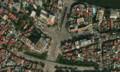 1/4 This is a picture of a really wide road in Vietnam and the surrounding roads... (Maxar satellite imagery).
 -
 2/4 ... and as expected, the roads' "wideness" roughly correspond to its importance. (Maxar satellite imagery)
 -
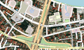
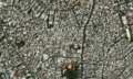
 3/4 You might expect that all of these roads are just secondary or tertiary roads here... (Maxar satellite imagery)
 -
 4/4 ... but that's wrong! This is because these roads are designated as QL32 (national road 32) and ĐT316 (provincial road 316). Designation by the government made all the difference. (Maxar satellite imagery)


Also, due to the nature of roads in Vietnam, outdoor road mapping in urban areas is strongly encouraged compared to armchair mapping. This is because alleys and even some residential roads are often being obscured by tube houses. Also, for this reason, most maps have alley in completely wrong places in Vietnam. This is a reality that mappers from more developed countries that has better urban planning must accept.
- Chaos in Hồ Chí Minh City
-
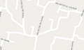
 1/4 You might think that the OSM mappers have done a terrible job... (OSM map)
 -
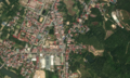
 2/4 ... but once you see the aerial imagery, yeah... You couldn't do a better job than them either. (Maxar satellite imagery)
 -
 3/4 Closer look (OSM map)
 -
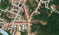
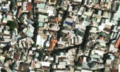 4/4 Closer look (Maxar satellite imagery)


Reference table
| JOSM | iD editor | Urban area description | Rural area description | Rendering |
|---|---|---|---|---|
highway=motorway
|
Motorway | The expressways or freeways, often numbered with prefix CT. (Vietnamese: cao tốc for high-speed or expressway). These are roads classified as expressways by the Vietnamese government. Usually elevated highways in metrolitan areas where highspeed traffic is allowed, and freeways connecting to the inter-provincial freeways. | The expressways or freeways, often numbered with prefix CT. (Vietnamese: cao tốc for high-speed or expressway), parts of the national freeway network. | 
|
highway=trunk
|
Trunk road | Main thoroughfares: large main roads leading to big cites, or the largest arterial roads inside a big city (but not motorways), often with multiple lanes, connecting several urban districts. | National routes. Long and large roads connecting provinces and regional centres of Vietnam, often prefixed QL. (Quốc lộ national road). | 
|
highway=primary
|
Primary road | Main arterial roads in cities: large roads connecting districts in a big city, often connecting several urban districts, have high volume of traffic, but have less signficance than trunks. | Smaller national routes, also coded QL. connecting smaller provinces or two provinces only.
|

|
highway=secondary
|
Secondary road | Main roads in one district, or roads connecting one or two urban districts together, and NOT the main arterial of that city. | Provincial roads. Standard tag for most provincial roads, coded ĐT. connecting rural districts and cities and towns together. | 
|
highway=tertiary
|
Tertiary road | This is the main road in a neighbourhood, suburb, and ward. One road that connecting several residential roads together. | The only one main road connecting a commune to the other, usually leading to the government office (people's committee office of the commune). Standard tag for district roads classified as Đường huyện, coded ĐH. | 
|
highway=residential
|
Residential road | A common public road in a city not having higher significance. At least two cars can drive safely in that road.
|
A public roads in a village (thôn), a residential settlement, and where there are houses. | 
|
highway=service
|
Service road | Mainly private driveways or access roads to homes or businesses for a few hundred meters maximum, does not have a through connecting function.
Passable by vehicles with 4 or more wheels, motorcycles, bicycles, or foot traffic. Any roads inside said private properties, such as roads from the entrance to car parks, garage and delivery points. See also: |

| |
highway=service + service=alley
|
Alley | A common public road in a city not having higher significance. The road is two small (alleys, or laneways), where only one car or two scooters can safely run. They are often named ngõ, ngách or hẻm. |
| |
highway=track
|
Unmaintained track road | Access route from dwellings to agricultural and forestry areas. No connection function between settlements. Roads leading to farms, and connecting the villages and farms only. Forest roads that are used for forest management are also among this. | 
| |
highway=unclassified
|
Unclassified road | Any highway that doesn't fit the criteria above. They are often very small and still have public access. Consider tagging them as highway=service instead if possible.
|
| |
highway=footway
|
Footway | Not a highway. Cars and other vehicles cannot go on here. Only suitable for walking or running; common in parks and in trekking areas. Avoid using highway=path if possible, use a more specific tag instead. See also: footway=sidewalk and footway=crossing.
|

| |
highway=pedestrian or highway=living_street
|
Pedestrian roads/Living street | Fairly rare in Vietnam. Pedestrian streets are roads that theoretically can be driven on by cars, but is legally not allowed. Living streets are roads inside a small local neighbourhood (often in apartment complexes) designed as shared space for motor vehicles and pedestrians. | 
| |
Public transport and ferries

Bus (xe buýt) transport in Vietnam is fairly extensive. Therefore, it is fairly important to map bus routes on OSM, and given that other websites even use OSM as a basemap for their routes, it would be more convenient for data consumers to just put it in OSM directly. In recent years private companies (such as VinBus) also operate public buses, albeit usually for serving their apartment complex residents only. In Hanoi, these buses are usually named E0X, where X is a number.
For ferries (phà), it is fairly popular in Hanoi and very popular in the Southern Vietnam. The ferry stations are often smaller compared to European counterparts. The only way to know for sure is to search it. Try the search term "Phà" + name of provinces if you want to find more info. See these websites for useful resources:
- Official gov websites: https://timbus.vn for Hanoi, https://ecobus.danang.gov.vn/ for Đà Nẵng and http://buyttphcm.com.vn/RouteFinding for Hồ Chí Minh city.
- Private companies: https://maps.vinbus.vn/ for VinBus (also have English).
- Tip for getting websites at other provinces: search "Tìm buýt" + name of the province. Tìm buýt literally means "find a bus".
Trains and metros
The train network in Vietnam is very tiny compared to other countries. Even after decades, the metro system in Vietnam is virtually nonexistent: as of 2023 only one (yes, as in number 1) line is operational. See this page in Wikipedia for more information: List of railway lines in Vietnam, List of railway stations in Vietnam and Hanoi Metro.
Airports
- Main article: Airport
See this for more info: ![]() List of airports in Vietnam.
List of airports in Vietnam.
Landcover
The reason I want to start with landcovers before mapping buildings is because mapping landuses would help you get the hang of seeing fine details before mapping buildings. It is very, very easy for you to get lost with mapping buildings, even with outdoor surveys, and that can quickly wither your soul.
natural=* and landuse=* will provide you with a very comprehensive list of landcovers, but to recap, these are the most commonly encountered ones in Vietnam: