WikiProject Belgium/Walking Node Networks
| WikiProject Belgium +/- | ||
| Conventions | ||
| Subprojects | ||
Conventions
See this page to learn how to tag walking routes in Belgium.
Legend
| Status | Description |
|---|---|
| No relation made yet | |
| Relation made, but most of the route is missing | |
| Significant parts of the route are missing | |
| Only a small part of the route is missing, or the main route is done and some alternative routes are missing | |
| Route is completely mapped |
Walking node networks
-
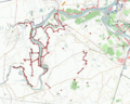 Walking network in Scheldeland and Klein-Brabant (13-04-2009)

Antwerpen
Antwerpse Kempen
This network consists of several subnetworks, the global network:
| Description | Relation | Status | Sign |
|---|---|---|---|
This network contains:
|
Collection of all the routes and its nodes: Relationship is incomplete (more nodes and routes in OSM)
1712195 |

|
The subnetworks
Kempense Beemden
| Description | Relation | Status | Sign |
|---|---|---|---|
| Kempense Beemden in Vorselaar, Grobbendonk, Lille en Zandhoven. | Collection of all the routes and its nodes: Relationship is incomplete (more nodes and routes in OSM)
2505512 |
|
Kempense Heide
| Description | Relation | Status | Sign |
|---|---|---|---|
| Kempense Heide in Brasschaat, Brecht, Essen, Kalmthout, Kapellen and Wuustwezel | Collection of all the routes and its nodes: Relationship is incomplete (more nodes and routes in OSM)
2172380 |
|
Kempense Heuvelrug
| Description | Relation | Status | Sign |
|---|---|---|---|
| Kempense Heuvelrug in Retie, Kasterlee and Herentals | Collection of all the routes and its nodes: Relationship is incomplete (more nodes and routes in OSM)
2172382 |
|
Kempense Hoven
| Description | Relation | Status | Sign |
|---|---|---|---|
| Kempense Hoven in Zoersel, Beerse, Vosselaar, Lille, Malle, Ranst, Zandhoven, Schilde, Schoten, Brecht and Rijkevorsel | Collection of all the routes and its nodes: Relationship is incomplete (more nodes and routes in OSM)
2172339 |
|
Kempense Kolonie
| Description | Relation | Status | Sign |
|---|---|---|---|
| Kempense Kolonie in Hoogstraten en Merksplas | Collection of all the routes and its nodes: Relationship is incomplete (more nodes and routes in OSM)
2172320 |
|
Kempense Landduinen
| Description | Relation | Status | Sign |
|---|---|---|---|
| Kempense Landduinen in Balen, Geel, Meerhout | Collection of all the routes and its nodes: Relationship is incomplete (more nodes and routes in OSM)
2172383 |
|
Kempens Landgoed
| Description | Relation | Status | Sign |
|---|---|---|---|
| Kempense Landgoed in Turnhout, Arendonk, Oud-Turnhout, Ravels | Collection of all the routes and its nodes: Relationship is incomplete (more nodes and routes in OSM)
2172380 |
|
Kempense Meren
| Description | Relation | Status | Sign |
|---|---|---|---|
| Kempense Meren near Mol | Collection of all the routes and its nodes: Relationship is incomplete (more nodes and routes in OSM)
2923019 |
|
Kempense Netevallei
| Description | Relation | Status | Sign |
|---|---|---|---|
| Kempense Netevallei in Lier, ... since Q3/20112 | Collection of all the routes and its nodes: Relationship is incomplete (more nodes and routes in OSM)
2442510 |
|
De Merode
| Description | Relation | Status | Sign |
|---|---|---|---|
|
|
Collection of all the routes and its nodes: Relationship is incomplete (more nodes and routes in OSM)
1711342 |
|
Klein-Brabant
The map that goes with this network is called "In het Land van Stille Waters", it covers the area between Rupel and Schelde.
This network is connected with the Scheldeland network.
Rivierenland
| Description | Relation | Status | Sign |
|---|---|---|---|
|
Collection of all the routes and its nodes: Relationship is incomplete (more nodes and routes in OSM)
1698153 |
|
Borsbeek
| Description | Relation | Status | Sign |
|---|---|---|---|
|
6376491 |

|
Limburg
Wandelnetwerk Bosland
| Description | Relation | Status | Sign |
|---|---|---|---|
|
Collection of all the routes and its nodes: Relationship is incomplete (more nodes and routes in OSM)
8450749 |
|
Wandelnetwerk Ham
| Description | Relation | Status | Sign |
|---|---|---|---|
|
Collection of all the routes and its nodes: Relationship is incomplete (more nodes and routes in OSM)
6065466 |

|
Wandelnetwerk Lummen
| Description | Relation | Status | Sign |
|---|---|---|---|
|
Collection of all the routes and its nodes: Relationship is incomplete (more nodes and routes in OSM)
3440738 |
|
Voerstreek
This network opens July 2008 (info).
Oost-Vlaanderen
Meetjeslandse Kreken
| Description | Relation | Status | Sign |
|---|---|---|---|
|
Collection of most routes and its nodes.
2211047 |
|
Meetjeslandse Bossen
| Description | Relation | Status | Sign |
|---|---|---|---|
|
A small number of nodes and routes needs to be checked on the ground.
5684763 |
|
Vlaamse Ardennen
Toerisme Oost-Vlaanderen started a network in Kluisbergen in 2009.
| Description | Relation | Status | Sign |
|---|---|---|---|
|
Network is completed without significant omissions or errors.
1831598 |
| |
|
Network is completed without significant omissions or errors.
7124075 |
| |
|
Network is completed without significant omissions or errors.
7141123 |
|
Scheldeland
This network consists of several subnetworks:
| Description | Relation | Status | Sign |
|---|---|---|---|
This network contains:
|
Only a small part is in East-Flanders, around Hamme and Dendermonde. This part is completed.
1710907 |
|
Kalkense Meersen Donkmeer
| Description | Relation | Status | Sign |
|---|---|---|---|
| A small number of nodes and relations needs to be surveyed for correct reconstruction in OSM.
5555132 |
|
Brabantse Kouters - West
| Description | Relation | Status | Sign |
|---|---|---|---|
Can be found around Buggenhout and was extended in 2018 towards Aalst. |
Collection of all the routes and its nodes: Relationship is incomplete
(2018 extension is being surveyed)
1744582 |
|
Waasland
| Description | Relation | Status | Sign |
|---|---|---|---|
|
Collection of all the routes and its nodes: Relationship is incomplete
11819338 |
| |
|
Collection of all the routes and its nodes: Relationship is incomplete
11986856 |
|
Vlaams-Brabant
Brabantse Kouters (Oost)
| Description | Relation | Status | Sign |
|---|---|---|---|
|
Collection of all the routes and its nodes:
8765292 |
|
Brabantse Kouters (West)
| Description | Relation | Status | Sign |
|---|---|---|---|
|
Collection of all the routes and its nodes:
8705110 |
|
Pajottenland
| Description | Relation | Status | Sign |
|---|---|---|---|
|
Collection of all the routes and its nodes:
1833700 |
|
Zuid-Dijleland
| Description | Relation | Status | Sign |
|---|---|---|---|
* Open on 26 june 2011
|
Collection of all the routes and its nodes:
1641610 |
|
Getevallei
| Description | Relation | Status | Sign |
|---|---|---|---|
|
Collection of all the routes and its nodes:
5504862 |
|
Hagelandse Heuvels
| Description | Relation | Status | Sign |
|---|---|---|---|
* Open on june 2012
|
Collection of all the routes and its nodes:
2194331 |
|
West-Vlaanderen
Bulskampveld
| Description | Relation | Status | Sign |
|---|---|---|---|
| Collection of all the routes and its nodes:
1834580 |
|
Heuvelland
| Description | Relation | Status | Sign |
|---|---|---|---|
|
Collection of all the routes and its nodes:
2377980 |
|
Hoppeland
| Description | Relation | Status | Sign |
|---|---|---|---|
|
Collection of all the routes and its nodes:
3862590 |
|
Ijzervallei
| Description | Relation | Status | Sign |
|---|---|---|---|
|
Collection of all the routes and its nodes:
12748157 |
|
Ieperboog
| Description | Relation | Status | Sign |
|---|---|---|---|
|
Collection of all the routes and its nodes:
2377988 |
|
Land van Mortagne
| Description | Relation | Status | Sign |
|---|---|---|---|
|
3438553 |
|
Westkust
| Description | Relation | Status | Sign |
|---|---|---|---|
| Collection of all the routes and its nodes:
2099497 |
|
Zwin
| Description | Relation | Status | Sign |
|---|---|---|---|
|
Collection of all the routes and its nodes:
2335105 |
|
Kust
| Description | Relation | Status | Sign |
|---|---|---|---|
|
Collection of all the routes and its nodes:
3216759 |
|
Velden en Meersen
| Description | Relation | Status | Sign |
|---|---|---|---|
|
Collection of all the routes and its nodes:
8300603 |
|