WikiProject Belgium/Conventions/Cycleways
| WikiProject Belgium +/- | ||
| Conventions | ||
| Subprojects | ||
The Bicycle wiki page provides general information for tagging bicycle related features on OSM. This page provides additional tagging guidelines suitable for cycle ways in Flanders.
Basic Information
Both the Belgian highway code and OSM distinguish cycling infrastructures which are part of a road from the ones who are not.
Cycling infrastructure that is part of a road / alongside a road is indicated as follows :
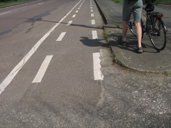
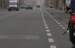
- Roads with striped markings on the nearside edge of the road: the insides are cycle lanes. If the below mentionned road signs are missing (or you missed them) then use the road markings to determine the correct tagging procedure. Refer to highway code, artikel7.4
- Mandatory road signs. For properly tagging these cycle paths please have a look at Traffic Signs: Mandatory signs. It will make you return here soon after :)
D7,
D9 and
D10
Cycling infrastructure that is not part of a road is indicated either with an F99x sign or with a C3 sign accompanied by a special permission for bicycles, provided that it has been designed for bicycles :
F99a
F99b
F99c
C3+M2 or
C3+M3


Note that there is no consensus as to the meaning of 'designed for bicycles' and hence the decision to tag these roads as highway=cycleway or as highway=path + bicycles=yes or else. Pls have a look at User:Eimai/Belgian_Roads#Paths and Tag:highway=cycleway - OpenStreetMap Wiki for more information about the highway=* tag.
For the "fietssnelwegen" that are not built along roads, the provinces of West-Vlaanderen and Vlaams-Brabant typically use the C3 + M2/M3 sign while Oost-Vlaanderen, Antwerpen and Limburg use the D7 sign. The Vlaamse Waterweg imposes C3 + 'jaagpad' on their towpaths. Wallonia uses different variants of F99a for all RAVels.
The information below only handles cycle paths/tracks which are part of a road / alongside roads.
Cycling infrastructure that is part of a road
Choosing between cycleway=lane and cycleway=track
The Flemish ministry for transport and public works (MOW) has a bicycle-oriented guide available, which describes the requirements to which cycleways and related infrastructure should adhere. Below follows a table with an OSM-mapping key.
| Picture | Description EN | Minimal tagset |
|---|---|---|
|
On-road, one-way cycle lane, with minimum 25cm and maximum 1 metre between the road and the cycle lane. The main criterium is "on-road". |
||
|
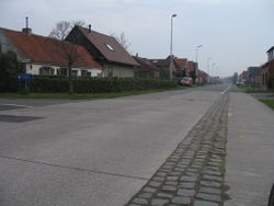
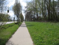
Separate cycle path, at least 1 metre from the road or with an appropriate separation barrier (such as a bush) between the path and the road. |
or |
Choosing between cycleway=track and creating a separate highway=cycleway
In case of a separate cycle path marked with the D7, D9 or D10 signs, tag the main road with cycleway=track. For complicated junctions, separate the cycle path and tag it with highway=cycleway; and tag the main road with bicycle=use_sidepath or no as appropriate. Drawing individual cycle paths next to roads brings with it its own problems, and makes tagging cycle routes more complicated.
Different cycleways at the two sides of the road
If one side of the road has a different kind of cycle path from the other, use cycleway:left=* and cycleway:right=*. In case one side of the road has a separately drawn cycle path, use bicycle:forward=use_sidepath or bicycle:backward=use_sidepath as appropriate. Left, right, forward and backward are always relative to the direction of how the way in OSM is drawn.
Optional Tags
Separate Cycle Paths highway=cycleway
| Tag | Description |
|---|---|
cycleway:width=2.50 |
Cycle path width in metres |
cycleway:buffer=9.25 |
Distance between cycle path and adjacent road |
cycleway:surface=asphalt |
Other options include: concrete, concrete plates, paving_stones, paving_stones:20, paving_stones:30, cobblestone, cobblestone:flattened, ground and gravel |
On-road cycle lanes cycleway=lane or cycleway=track
| Tag | Description |
|---|---|
cycleway:width=2.50 |
Cycle lane width in metres |
cycleway:buffer=2.50 |
Width of space between the cycle lane and the road. Consider parking spaces, grass verges and hedges. |
cycleway:surface=asphalt |
Other options include: concrete, concrete plates, paving_stones, paving_stones:20, paving_stones:30, cobblestone, cobblestone:flattened, ground and gravel |
If a road contains two different types of cycle lane/path, use the following tag to note the width of the path on the right hand side of the road, in the direction of the way in OSM: cycleway:right:width=2.50
One-way streets
Use oneway:bicycle=no if cyclists are allowed to cycle in contra-flow. Conversely, use oneway:bicycle=yes if the street is also oneway for bicycles (only if you have verified this, of course).
See Bicycle#Cycle_features for examples, including how to tag bidirectional cycle lanes on one side of the road.


