It is very important to follow these guidelines when contributing in an area where data already exists in OpenStreetMap, and where local people have been contributing. In general you can be more relaxed about armchair mapping in areas of the world which are more remote, or otherwise have less pre-existing data.
Learn to recognise valuable data. There are various tools and techniques, some more complex than others, for figuring out who's done what within the OpenStreetMap data. These are all valuable skills to avoid doing damage while armchair mapping.
Specify what sources you are using. Add source=* tags onto objects you have mapped, and/or add a comment on the changeset, to say whether you are mapping from aerial imagery, or other map sources, or from survey, or from a combination of these.
Imagery can be wrong! This is the golden rule to remember.
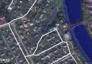
Check imagery alignment. Imagery is very frequently misaligned from reality with an offset in one particular direction. If you notice that all of the data is off to one side, don't move the data, try to re-align your background imagery layer to match. Offset imagery Bing in Pskov(Russia) If you see this, do not start moving all the data In Potlatch you do this by holding down the space bar while dragging. Although armchair mapping often involves moving roads to match with imagery, you should not go shifting large areas of data where that shift is all in one particular direction, at least not unless you have reason to believe that existing data is from a less accurate source than your imagery.
Things change. Imagery gets old. Road layouts change. Buildings get knocked down and rebuilt in different places. Imagery can be many years old. Armchair mapping involves blindly copying this information but in an area where locals have contributed, you should be very careful about this. Look out for tell-tale signs. If the whole area has building outlines drawn in, and you see just one missing, or one drawn in completely the wrong shape, don't just "fix" it. Alarm bells should be ringing. One approach would be to just leave a fixme=* tag. (Conversely mappers could leave a note=* tag on elements or on a standalone node to warn of recent real world changes and out-of-date imagery. We have no firmly established routine for this)
If in doubt, assume that existing data has been mapped by local people on the ground. Sometimes you will be able to tell this by seeing source tags or just by contacting users to ask!
You can gain a better understanding of the reasoning behind these guidelines, with the 'Disadvantages and controversy' section below.
Guidelines for event organisers
Coordinated armchair mapping events are not something we have experimented with often. When organising an intensive en-masse armchair mapping event, organisers have the opportunity to teach users about these guidelines and ensure that they are followed. They also have the opportunity to screw this up. Organisers should be acutely aware of all of the guidelines and their reasoning seen in the following section. In addition there are several steps which should be taken in advance of an event.
Organisers must take steps to inform all participants about these guidelines and the issues around armchair mapping. This should include linking to this page from any publicity about the event (e.g. from a wiki page about the event) and perhaps copying or summarising sections of this page.
Organisers should think carefully about target regions for armchair mapping, selecting areas where there is less pre-existing valuable data, and communicating these selected regions to the participants. Providing rigid indicators for regions to map, using tools such as MapCraft or the HOT tasking server, may be a good way to direct participants to map in sensible areas, however the set-up of these regions is then all the more important. Where participants are to be given more choice of where to do their armchair mapping, this increases the need for them to be educated about the guidelines and issues on this page.
Organisers should take steps to contact the local mapping community and consult with them on target regions for armchair mapping. Where there is pre-existing contributed data, this means identifying key contributors and seek their buy-in to the idea. In the absence of pre-existing data, community contact channels at the regional or country level should still be used to inform locals however possible. This includes local wiki pages under List of territory based projects, country-level Mailing Lists and whatever Contact channel is most heavily used by locals.
Advantages
You can map from your armchair. If you are not able to get out to do mapping on the ground you can still contribute to the project.
The entry level to participate is lower, you don't need expensive equipment.
Speed, quicker to get coverage and fill in blank areas of the map. You can get many, many times more basic coverage (road and building outlines) mapped doing armchair versus normal mapping.
Some areas have very little coverage mapped. There are likely no mappers in some remote area. Humanitarian mapping for disasters, HOT mapping, is often done entirely as an armchair mapping process, with only smaller scale mapping projects achieved by people on the ground.
Safety. You might not feel safe/comfortable in some areas to go manual street mapping therefore armchair mapping is a sensible option.
Access. Some areas you cannot get access or difficultly getting access. Locked estates, restricted areas, Schools, etc. For these mapping via aerial imagery is often the only option.
With aerial images you get get more accuracy, issues of misaligned imagery notwithstanding. The geometry and proportions of roads and structures can be more detailed. e.g. You can get much better curves of roads via armchair mapping placing lots of nodes along the centre of the road.
Many things like roads, buildings, etc don’t change for decades can be mapped with reasonable confidence.
Disadvantages and controversy
OpenStreetmap treasures the contributions of local people who go out and map their neighbourhood. We love people to do that, and we would love more people to do that. In this way we can create a truly uniquely valuable map of the world. There is a sense in which this represents the heart and soul of OpenStreetMap. We create maps where people care about the data enough to go out and collect it. Our dataset comes with a community of mappers who support it. In areas where we don't have that community yet we should do what we can to attract and build the mapping community. Nothing should be allowed to discourage this, and unfortunately armchair mapping is widely believed to do so. Three reasons:
Although going out surveying isn't always convenient, there's some truth in saying that time we spend on armchair mapping is time which could have been spent on survey-based mapping. What's more, every mailing list post or blog post or wiki page describing armchair mapping could steer new visitors towards this approach and away from the more valuable process of mapping their own neighbourhood.
It can be argued that even if armchair mapped data is not interfering with existing surveyed data, its sudden rapid arrival discourages people from doing the better survey-based mapping in a particular area. If OpenStreetMap feels like a dumping ground for low quality data gathered by means of easy quick shortcuts, this does not encourage people to work on the map in the way we would really like them to (Note that similar arguments are made about imports. Perhaps armchair mapping can be regarded as a step on a sliding scale towards the damaging effects of mass data imports)
Armchair mappers have occasionally been found to be damaging or undoing the hard work of surveying mapping contributors.
The first two points are rather philosophical, based on the psychology of users who may or may not become new contributors. They're difficult to prove or disprove, and whether you view them as a major problem will depend on how you weigh against the considerations of the value of armchair mapped data. For a given area of data, armchair mapped data is less valuable than painstakingly gathered on-the-ground surveyed data, but how much less valuable is debatable.
The third point is a problem we can try to mitigate by laying down some armchair mapping guidelines, and trying to educate new users about what is accepted practice for armchair mapping.
Unavoidable mistakes when mapping from imagery
In addition to the issues of imagery being out of date or misaligned, some common mistakes result from armchair mapping from aerial imagery without a corresponding survey. Armchair mappers should be alert to these issues, and try avoid them if possible, but mostly they are unavoidable and will always be an issue with armchair mapping.
Connecting roads that don't connect. Fences, gates, and gutters all stop features from connecting. Tree cover at the end of roads can often make it difficult to see if one road connects to another or if there is a connection
Mapping private features. Private backyard tennis courts and swimming pools are probably best left unmapped. Is that a cut-thru between streets, or really just a driveway of a house that connects to the house in front and behind?
Everything green and leafy from the air, isn't always a park or a wood on the ground.
Take particular care before attempting to map hiking trails from your armchair. Someone who follows a noexit mapped road in their car, will likely just curse their GPS and take another route. However, some serious obstacles in forest areas are easy to miss from aerial imagery - remember the map user can't tell that one trail has been mapped by a hiker who has done it, and another trail may have been mapped by a virtual hiker who may have never been near the trail.
Further Information
Roof modelling - techniques for drawing buildings and avoiding errors in the interpretation of roof geometry from aerial images.