DE:Featured images/Jan-Mar 2014
Jump to navigation
Jump to search


Hier sind die vorgestellten Bilder zu sehen. Die Bilder wurden als Vorzeigebeispiele des OpenStreetMap-Projektes auserwählt.
Wenn du ein Bild hast, welches als Bild der Woche sein könnte, dann kannst du es hier auf der (en) Vorschläge des ausgewählten Bildes-Seite vorschlagen.
| ← von Januar bis März 2013 | ← von Oktober bis Dezember 2013 | von April bis Juni 2014 → | von Januar bis März 2015 → |
Galerie der vorgestellten Bilder, von Januar bis März 2014

2014, Woche 1
2014, Woche 2
2014, Woche 3
2014, Woche 4
2014, Woche 5

2014, Woche 6

2014, Woche 7
2014, Woche 8

2014, Woche 9

2014, Woche 10
2014, Woche 11

2014, Woche 12
2014, Woche 13
Details und Beschriftungen
Woche 1 (von Montag, 30. Dezember 2013 bis Sonntag, 5. Januar 2014) [Edit]

- English : At CrisisCamp DC last month lots of people got involved in editing OpenStreetMap for Typhoon Haiyan crisis response.
- Deutsch : Beim CrisisCamp DC im November haben viele Personen für die OpenStreetMap-Aktion nach der Taifun-Haiyan-Katastrophe gemappt.
Woche 2 (von Montag, 6. Januar 2014 bis Sonntag, 12. Januar 2014) [Edit]

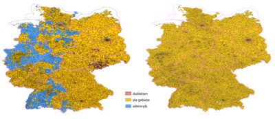
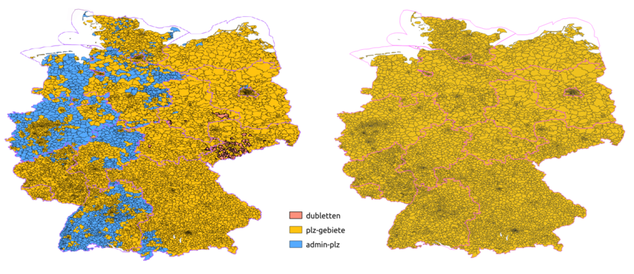
- English : In the last few weeks the German postal code areas were consolidated and checked: Before (left map) some postalcodes were tagged on admin boundary relations and duplicates existed. After (right map) all 8201 postalcode areas in Germany have their own postal_code relation. See the project page (in German).
- Deutsch : In den letzten Wochen wurden die deutschen Postleitzahlen-Gebiete konsolidiert und überprüft: Davor (linke Karte) waren viele PLZ-Gebiete nur auf administrativen Grenzrelationen getaggt, außerdem existierten Duplikate. Danach (rechte Karte) haben alle 8201 PLZ-Gebiete ihre eigene PLZ-Relation. Siehe auch die Projektseite.
Woche 3 (von Montag, 13. Januar 2014 bis Sonntag, 19. Januar 2014) [Edit]

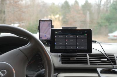
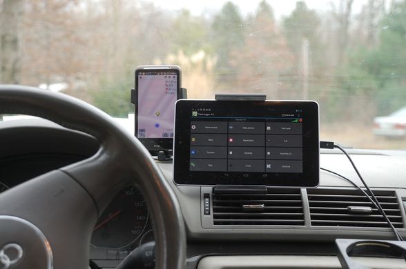
- English : A car dashboard kitted out with gadgets. This is just one of a wide variety of mapping techniques. Visible here (left to right): A smartphone running OsmAnd (information and map display) and a tablet computer set up with OSMtracker (POI recording).
- Deutsch : Die Verwendung eines Auto-Armaturenbretts voller Geräte ist nur eine der vielen verschiedenen Kartografie-Techniken. Hier zu sehen (von links nach rechts): Ein Smartphone, auf dem OsmAnd (Information- und Kartenanzeige) läuft, und ein Tabletcomputer, der mit OSMtracker (POI-Aufzeichnung) ausgestattet ist.
Woche 4 (von Montag, 20. Januar 2014 bis Sonntag, 26. Januar 2014) [Edit]

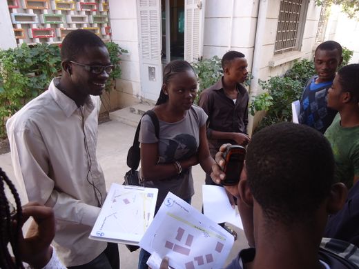
- English : The OpenSteetMap community in Senegal is growingǃ A lot of activities, training and presentations are happening these days. This photo shows architecture students during a surveying training session with Walking Papers printouts and GPS devices in Dakar.
- Deutsch : Die OpenSteetMap-Gemeinschaft in Senegal wächstǃ Zurzeit finden viele Aktivitäten, Trainings und Präsentationen statt. Dieses Foto zeigt Architekturstudenten während einem Erkundungs/Survey-Training mit Walking-Papers-Ausdrucken und GPS-Geräten in Dakar.
Woche 5 (von Montag, 27. Januar 2014 bis Sonntag, 2. Februar 2014) [Edit]

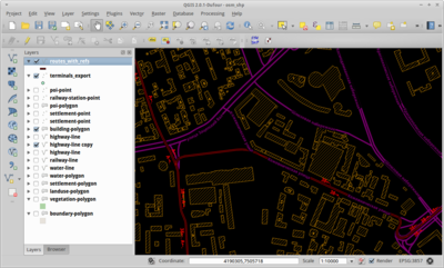
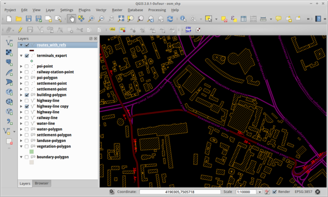
- English : Viewing OpenStreetMap buildings and tram data within the open source QGIS software.
- Deutsch : Visualisierung von OpenStreetMap-Daten (hier: Gebäude und Straßenbahnen) mit der Open-Source-Software QGIS.
Woche 6 (von Montag, 3. Februar 2014 bis Sonntag, 9. Februar 2014) [Edit]

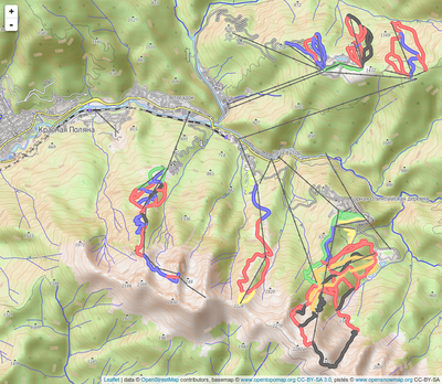
- English : The 2014 Olympics ski venues in the Krasnaya Polyana (Sochi) mountain cluster. This spontaneous mashup using Leaflet shows OpenSnowMap's ski pistes and lifts on OpenTopoMap as baselayer on a slippy map.
- Deutsch : Der Ski-Austragungsort der Olympischen Winterspiele 2014 in der Bergregion um Krasnaja Poljana (Sotschi). Ein spontan mit Leaflet erstellter Mashup zeigt Skipisten und Lifte aus OpenSnowMap auf einer OpenTopoMap-Hintergrundebene in einer Slippy Map.
Woche 7 (von Montag, 10. Februar 2014 bis Sonntag, 16. Februar 2014) [Edit]

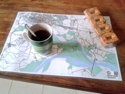
- English : A map of Pavia in Italy, rendered in high resolution using Maperitive, printed, laminated and used as a personal breakfast mat
- Deutsch : Eine Karte von Pavia in Italien, mittels Maperitive in hoher Auflösung gerendert, gedruckt, laminiert und jetzt als persönliches Platzdeckchen verwendet
Woche 8 (von Montag, 17. Februar 2014 bis Sonntag, 23. Februar 2014) [Edit]

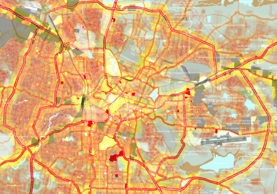
- English : Street network and built-up area of Bangalore (India). This colourful map was made based on OSM data using TileMill.
- Deutsch : Straßennetz und bebaute Fläche von Bangalore (Indien). Diese farbenfrohe Karte wurde mit TileMill aus OSM-Daten erstellt.
Woche 9 (von Montag, 24. Februar 2014 bis Sonntag, 2. März 2014) [Edit]

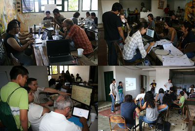
- English : Forty people gathered for an event in Managua, Nicaragua, working on improving the OSM data including public transportation, neighbourhoods and important POIs
- Deutsch : 40 Personen versammelten sich zu einer Mappingparty in Managua (Nicaragua). Sie arbeiteten unter anderem in den Bereichen öffentliche Verkehrsmittel, Stadtteile und wichtige POIs an der Verbesserung der OSM-Daten.
Woche 10 (von Montag, 3. März 2014 bis Sonntag, 9. März 2014) [Edit]

- English : 1st “OpenStreetMap Workshop from scratch” – a free and open event that brought together artists, cartographers, marketing companies and territorial planning/computer science students as part of the activities of the HackLabCocha in Cochabamba, Bolivia. View the full set of photos.
- Deutsch : Der erste „OpenStreetMap-Workshop ab Null“ – eine freie und offene Veranstaltung, die Künstler, Kartographen, Vermarkter und Raumplanung-/Informatik-Studenten zusammengebracht hat. Sie fand im Rahmen von HackLabCocha in Cochabamba (Bolivien) statt. Betrachte das ganze Fotoalbum.
Woche 11 (von Montag, 10. März 2014 bis Sonntag, 16. März 2014) [Edit]

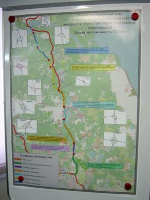
- English : A map of the “Sortavala” highway in Russia, on display at the road construction company offices. This poster has an OSM base map, and also inset details of road junctions based on the OpenStreetMap contributors data.
- Deutsch : Eine Karte der russischen „Sortavala“-Straße in einem Büro des Straßenbauunternehmens. Das Poster zeigt auf einer OSM-Karte mit hervorgehobener Straße einige Kreuzungsdetails, die ebenfalls auf OSM-Daten basieren.
Woche 12 (von Montag, 17. März 2014 bis Sonntag, 23. März 2014) [Edit]

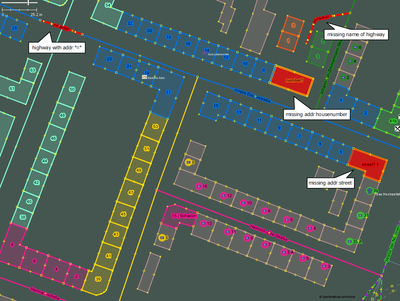
- English : This new "Coloured Streets" mappaint style makes working with addresses easier within JOSM. Addresses are given the same colour as the streets they are assigned to.
- Deutsch : Der Mappaint style Coloured Streets für JOSM stellt Adressen und Straßen mit gleichem Namen in der gleichen Farbe dar.
Woche 13 (von Montag, 24. März 2014 bis Sonntag, 30. März 2014) [Edit]

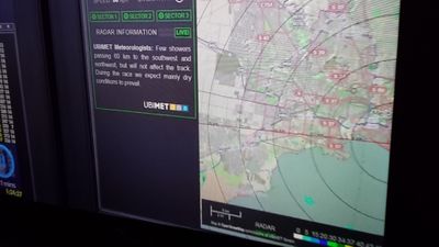
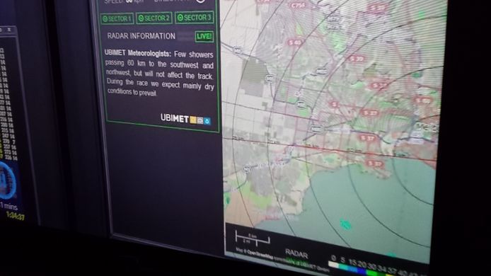
- English : OSM used as a backdrop on the weather radar for the Formula One Grand Prix at Melbourne. (TV photo)
- Deutsch : OSM als Hintergrund des Wetterradars beim Formel-1-Grand-Prix in Melbourne. (Fernsehbild)