Mapping projects
Jump to navigation
Jump to search
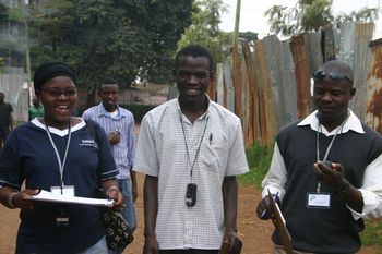

The Mapkibera Project is training local people of Kibera, Nairobi, to create and own their map with OpenStreetMap.
Mapping projects are collaborative efforts by people with common interests to map a particular territory or to improve mapping for a particular topic. There are mapping projects for most countries in the world and for many special-interest areas. There are also projects that develop and improve the software and services that make OpenStreetMap possible.
List of territory based projects
See the list of territory based projects for information on mapping projects in virtually every country on earth. Follow the links to more local mapping down to the region and city level.
Special interest topics
- See also: Category:Projects
There are communities within OpenStreetMap interested in mapping many different features. See the Features category for an introduction to mapping many different types of features. Interest areas include:
- Accessibility: accessibility (mapping for inclusive accessibility using OpenStreetMap for various groups, including the blind (see OSM for the blind), mapping wheelchair-accessible places (see Wheelmap), routing for people in wheelchairs (see wheelchair routing)
- Borders and Administrative Boundaries: WikiProject United Nations political boundaries and WikiProject Import WDB are project focused on importing information about political boundaries between countries and territories from UN sources and from the CIA World Database.
- Census: GeoCensos community is mapping together with National Statistics Offices cities in developing countries in order to ask citizens to contribute with information about local buildings to the Openstreetmap platform. Although at this moment the project it’s only running a test and measurements will not replace any of the traditional surveying undertaken by national statistics office, the agencies want to see whether census collaborative mapping can be used as an additional tool of data collection.
- Collaborations: Wikipedia (interoperation with Wikipedia includes more than 1.7 MiB of data linking to Wikipedia articles displayed in the map)
- Development partners: OpenStreetMap development partners lets international development and humanitarian organizations list point people that are working on OpenStreetMap for better visibility and coordination.
- Drinking water: To satisfy a basic need and as an alternative to disposable plastic bottles, OSM has the world's largest catalog of drinking water sources.
- Food security: Volunteers are mapping and tagging sources of healthy, safe and nutritious food, including urban gardening resources. See the Food security page for ideas.
- Government: Substantial usage and contribution to OpenStreetMap by Governments. See the Government Usage page for more.
- Health Facility data: The Global Healthsites Mapping Project (Healthsites.io) is an initiative to build an open data commons of health facility data with OpenStreetMap
- Historic: For features that no longer exist in OSM and the world, the Open Historical Map project collects and renders a separate API, database and rendering stack, with the aim to have a time-enabled map of everything that used to exist.
- Humanitarian Relief: The Humanitarian OpenStreetMap Team coordinates the creation, production and distribution of free mapping resources to support humanitarian relief efforts in many places around the world. There will be many projects including WikiProject Haiti and 2011 Sendai earthquake and tsunami.
- Infrastructure: At the heart of OSM is information about the road network (see Highways), railways (use Railways for a tagging introduction and see Railways, below) and WikiProject Metro systems, a project to map the world's metro systems. There is also WikiProject Power networks, which focuses on mapping the electric and gas distribution and generation systems.
- Marine and Shipping: The OpenSeaMap project collects and adds information needed for navigation at sea, including locations of lighthouses and details of harbors. It displays this information with bathymetric data, weather charts and other dynamic data for all water-sport enthusiasts, such as sailors, divers and canoeists.
- Nature, Conservation and Environment: People in the environmental OSM project are active in adding information relevant to conservation of natural resources and habitats, as well as important cultural-heritage features (see Conservation). Other projects are waterways and WikiProject Corine Land Cover, which is about importing information on land cover and land use for Europe.
- Places of Worship: WikiProject Latter-day Saints (mapping places of worship)
- Railways: There is a great deal of rail data in OSM, both freight and passenger. See Category:WikiProject_Railways for a country-by-country view and try OpenRailwayMap to see how the world blossoms with rail networks!
- Recreation, Sports and Leisure: There are many groups mapping information relevant to different outdoor activities, including hiking (such as this), winter sports, WikiProject Whitewater maps, and IOF mapping (which is about orienteering sport maps).
- Special Populations: These include ethnic groups or geographical areas with unique characteristics, such as Native American reservations in the United States. Though Native American reservations, which tend to be rural, are included in USA's TIGER data, typically data are incomplete or inaccurate. Lately, tribes have taken matters into their own hands and have created their own data. This also is true in other parts of the world. The boundary=aboriginal_lands tag is better emerging to map official boundaries of these areas.
- Translation: There are several aspects of Translation in OpenStreetMap, including place names in the map itself. This is mostly coordinated under List of territory based projects but we also have WikiProject Esperanto, WikiProject Catalan, and WikiProject Spanish translation.
Technical projects
- WikiProject Cleanup (managing and improving this wiki)
- WikiProject Pictograms (creating and improving icons used on maps, particularly icons for point features)
- WikiProject Semantics (improving terms, classifications and ontologies used within OpenStreetMap)
- Routing (tagging to support routing by many transport modes)
- Indoor Mapping (mapping the interiors of buildings and structures)
See also
- Contact channels - contact people in various countries
- Local chapters - branches of the OpenStreetMap Foundation in different territories
- Research - research into the OpenStreetMap project and use of OpenStreetMap in education