Featured images/Apr-Jun 2009
(Redirected from Featured Images/Apr-Jun 2009)

These are featured images, which have been identified as the best examples of OpenStreetMap mapping, or as useful illustrations of the OpenStreetMap project.
If you know another image of similar quality, you can nominate it on Featured image proposals.
| ← from January to March 2009 | from July to September 2009 → | from April to June 2010 → |
Gallery of featured images, from April to June 2009
-
 2009, week 14
 -
 2009, week 15
 -
 2009, week 16
 -
 2009, week 17
 -
 2009, week 19
 -
 2009, week 20
 -
 2009, week 21
 -
 2009, week 22
 -
 2009, week 23
 -
 2009, week 24
 -
 2009, week 25
 -
 2009, week 26
Details and captions
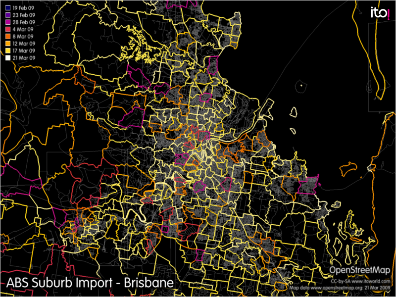
Week 14 (from Monday 30 March 2009 to Sunday 5 April 2009) [Edit]

- English : With the recently finished ABS Import of suburb boundary data, all of Australia has relatively up-to-date suburb boundary information. Image shows progress of import in Brisbane area, created using OSM Mapper.
Week 15 (from Monday 6 April 2009 to Sunday 12 April 2009) [Edit]

Week 16 (from Monday 13 April 2009 to Sunday 19 April 2009) [Edit]

- English : GroundTruth-generated relief contours map for Garmin GPS units. The elevation data source is SRTM. This is a MapSource screenshot of map tiles. See here for more info.
Week 17 (from Monday 20 April 2009 to Sunday 26 April 2009) [Edit]

- English : CloudMade's routing API gives turn-by-turn directions for vehicles, bicycles and pedestrians - all powered by OSM data (shown: route around Googleplex)
Week 18 (from Monday 27 April 2009 to Sunday 3 May 2009) [Edit]
Superscript text

- English : The building and open space layers from MassGIS for large swathes of Massachusetts have been imported thanks to effort by User:crschmidt and others in the region. [1]
Week 19 (from Monday 4 May 2009 to Sunday 10 May 2009) [Edit]

- English : Sir Tim Berners-Lee recently received both a doctor honoris causa award (for his outstanding contributions to the WWW [2][3]) and a hi-viz vest (for his outstanding mentions of OSM [4])
Week 20 (from Monday 11 May 2009 to Sunday 17 May 2009) [Edit]

- English : TopOSM is a topographic view of OSM data
Week 21 (from Monday 18 May 2009 to Sunday 24 May 2009) [Edit]

- English : MapAnalyst is an open source tool for distortion analysis in old maps, that uses OSM as a the default reference cartography. (Shown here: 1:50k map of Madrid dated from 1875)
Week 22 (from Monday 25 May 2009 to Sunday 31 May 2009) [Edit]

- English : The first GPS device donated by the OSM Foundation's GPStogo scheme at the mapping party and conference in Neiva Colombia
Week 23 (from Monday 1 June 2009 to Sunday 7 June 2009) [Edit]

- English : The Sunderland Mapping Party being an example of the successful Mapping parties idea. Sunderland was chosen from the UK Mapping Priorities list.
Week 24 (from Monday 8 June 2009 to Sunday 14 June 2009) [Edit]

- English : A printed map of Birmingham is available thanks to the Mappa Mercia subproject
Week 25 (from Monday 15 June 2009 to Sunday 21 June 2009) [Edit]

- English : A "heat-map" of OpenStreetMap complexity worldwide (Tah-heatmap)
Week 26 (from Monday 22 June 2009 to Sunday 28 June 2009) [Edit]

- English : The HaptoRender project has created the first tactile map using OpenStreetMap data.