File:Barrington-Leigh C, Millard-Ball A Density and completeness.png
Jump to navigation
Jump to search


Size of this preview: 800 × 400 pixels. Other resolutions: 320 × 160 pixels | 640 × 320 pixels | 1,024 × 512 pixels | 1,280 × 640 pixels | 2,560 × 1,280 pixels | 12,960 × 6,480 pixels.
Original file (12,960 × 6,480 pixels, file size: 14.53 MB, MIME type: image/png)
Summary
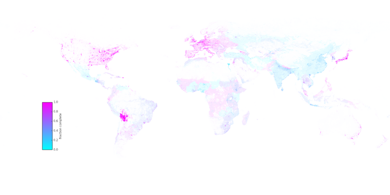
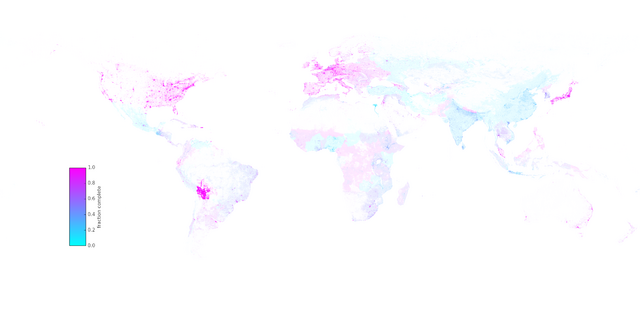
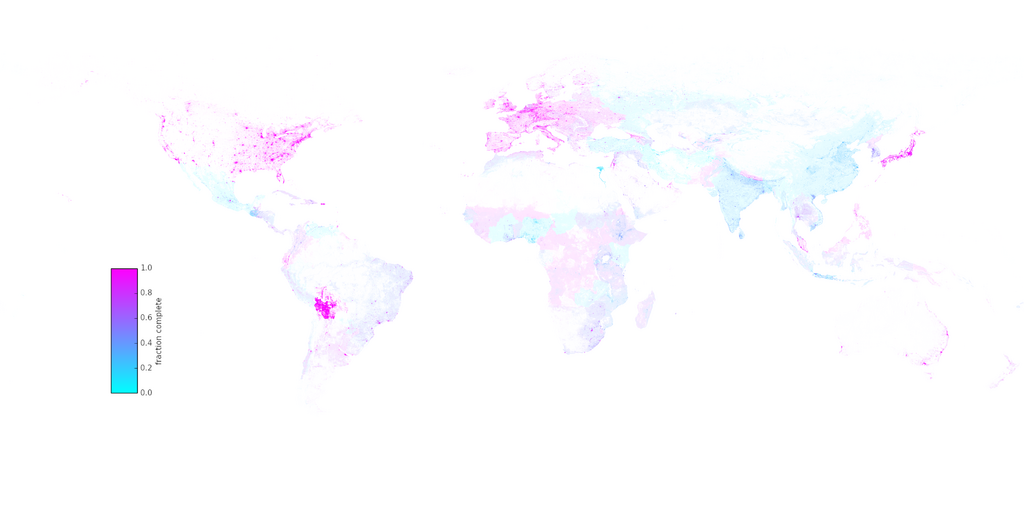
Figure 6 from research article "The world’s user-generated road map is more than 80% complete" Barrington-Leigh C, Millard-Ball A (2017) Higher res version from http://wellbeing.ihsp.mcgill.ca/publications/PLOS2017roads/
This is a Featured image, which means that it has been identified as one of the best examples of OpenStreetMap mapping, or that it provides a useful illustration of the OpenStreetMap project. If you know another image of similar quality, you can nominate it on Featured image proposals.
Front-page image for week 36 of 2017 (4–10 Sep.).
- Image descriptions
- English : A research article by Christopher Barrington-Leigh and Adam Millard-Ball has undertaken worldwide completeness analysis of OpenStreetMap's road coverage based on visual comparison of imagery and other statistical methods.
- français : Un article de recherche (en anglais) par Christopher Barrington-Leigh et Adam Millard-Ball décrit comment ils ont entrepris une analyse mondiale de la complétude de la couverture routière d’OpenStreetMap en se basant sur une comparaison visuelle de l’imagerie et sur d’autres méthodes statistiques.
- italiano : Una ricerca di Christopher Barrington-Leigh e Adam Millard-Ball ha intrapreso un'analisi mondiale di completezza (en) della copertura stradale di OpenStreetMap basata sul confronto visivo di immagini e altri metodi statistici.
- 中文(简体) : Christopher Barrington-Leigh 和 Adam Millard-Ball 的研究报告,依据影像和其他统计方法的视觉比对,进行全球尺度的开放街图道路网完整度分析。
- 中文(繁體) : Christopher Barrington-Leigh 和 Adam Millard-Ball 的研究報告,依據影像和其他統計方法的視覺比對,進行全球尺度的開放街圖道路網完整度分析。
- فارسی : Christopher Barrington-Leigh و Adam Millard-Ball در مقالهای تحیقاتی میزان کمال پوشش جادهای نقشهٔ باز شهری را بررسی کردند. این مطالعه بر پایهٔ مقایسهٔ تصویری با تصاویر هوایی و سایر روشهای آماری انجام شده است.
Licensing
The whole article (including images we assume) is licensed CC-BY 4.0
![]()
![]()
This work is licensed under the Creative Commons Attribution 4.0 License.
File history
Click on a date/time to view the file as it appeared at that time.
| Date/Time | Thumbnail | Dimensions | User | Comment | |
|---|---|---|---|---|---|
| current | 09:46, 8 September 2021 | | 12,960 × 6,480 (14.53 MB) | The RedBurn (talk | contribs) | -> lower than 125 MP |
| 09:33, 8 September 2021 | Error creating thumbnail: File with dimensions greater than 125 MP | 21,600 × 10,800 (36.26 MB) | The RedBurn (talk | contribs) | Higher res version | |
| 23:13, 7 September 2017 | 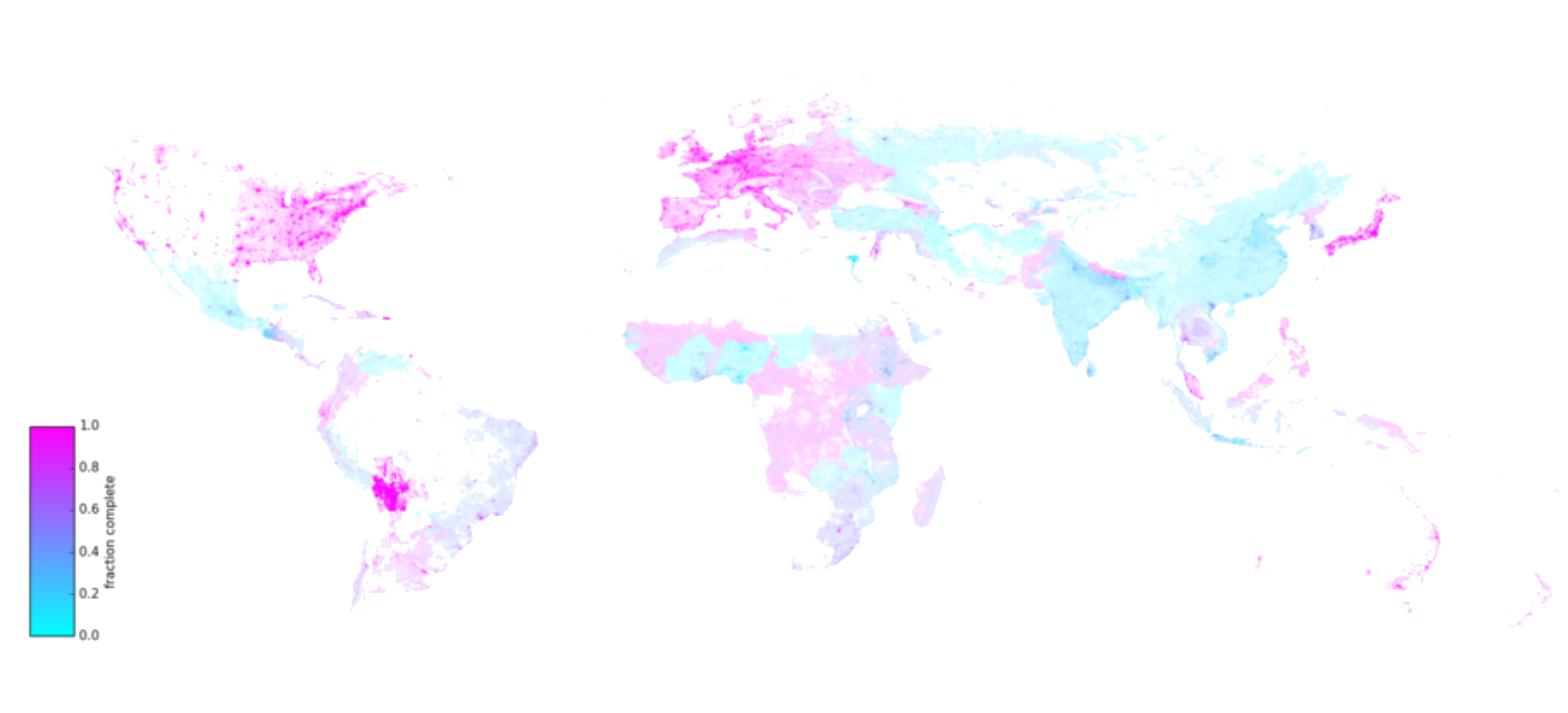 | 4,288 × 1,950 (1,020 KB) | Harry Wood (talk | contribs) | Figure 6 from [http://journals.plos.org/plosone/article?id=10.1371/journal.pone.0180698 research article "The world’s user-generated road map is more than 80% complete" Barrington-Leigh C, Millard-Ball A (2017)] The whole article (including images... |
You cannot overwrite this file.
File usage
The following 18 pages use this file:
- Completeness
- Fa:Completeness
- Featured images/Jul-Sep 2017
- List of featured images/2017
- Pt:Featured images/Jul-Sep 2017
- Uk:Featured images/Jul-Sep 2017
- Zh-hans:Featured images/Jul-Sep 2017
- Zh-hant:Featured images/Jul-Sep 2017
- Template:Iotw image/2017-36
- DE:Featured images/Jul-Sep 2017
- FR:Completeness
- FR:Featured images/Jul-Sep 2017
- ES:Completitud
- ES:Imágenes destacadas/Jul-Sep 2017
- IT:Featured images/Jul-Sep 2017
- RU:Featured images/Jul-Sep 2017
- JA:Featured images/Jul-Sep 2017
- JA:網羅性