Zh-hant:Featured images/Jul-Sep 2017
Jump to navigation
Jump to search


這是特色圖片,展現開放街圖畫地圖範例,以及最能代表開放街圖的專案。
如果你知道其他有類似品質的圖片,你可以在特色圖片提名處(en)提名。
| ← 從2016年7月到9月 | ← 從2017年4月到6月 | 從2017年10月到12月 → | 從2018年7月到9月 → |
特色圖片庫、從2017年7月到9月

2017年、第27週
2017年、第28週
2017年、第29週
2017年、第30週
2017年、第31週

2017年、第32週
2017年、第33週
2017年、第34週
2017年、第35週
2017年、第36週

2017年、第37週
2017年、第38週
2017年、第39週
細節和字幕
第27週(從2017年7月3日星期一到2017年7月9日星期日) [Edit]

- English : With drone pilots, Marines, Navy and Army's Scout Rangers, User:Schadow1 organised a mapping expedition in southern Philippines for logistics, navigation, military operations purposes, and tourism. 1,957 data elements were added by the expedition.
- 中文(繁體) : 在有了無人機操作員,海軍陸戰隊、海軍以及陸軍的偵察遊擊團的參與下,User:Schadow1 在菲律賓南方基於後勤、導航、軍事行動以及旅遊的目的,組織地圖探察團。這次探查總共增加 1,957 項的資料元素。
第28週(從2017年7月10日星期一到2017年7月16日星期日) [Edit]

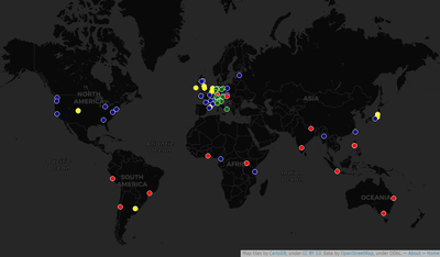
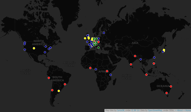
- English : An historical map locating all State Of The Map conferences that took place since 2007. An interactive map is also available, made with UMap.
- 中文(繁體) : 一張截至的歷史性地圖,列出所有全曾举行 State Of The Map 大会地点。另外也有 UMap 版本的 互動地圖。
第29週(從2017年7月17日星期一到2017年7月23日星期日) [Edit]

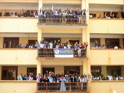
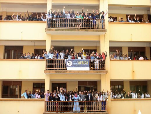
- English : The first “State of the Map Africa” conference took place one week ago in Kampala, Uganda.
- 中文(繁體) : 第一次 “State of the Map Africa 大會” 一週前在烏干達坎帕拉舉行。
第30週(從2017年7月24日星期一到2017年7月30日星期日) [Edit]

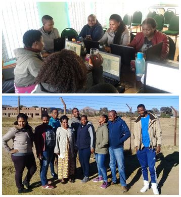
- English : Mzwandile Thokoane from the MapLesotho project, lead a mapping event to bring advanced JOSM mapping back to Hlotse, in Leribe, Lesotho.
- 中文(繁體) : MapLesotho 專案的 Mzwandile Thokoane 組織繪圖活動,要將進階的 JOSM 繪圖技巧帶回賴索托萊里貝區的萊里貝。
第31週(從2017年7月31日星期一到2017年8月6日星期日) [Edit]

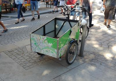
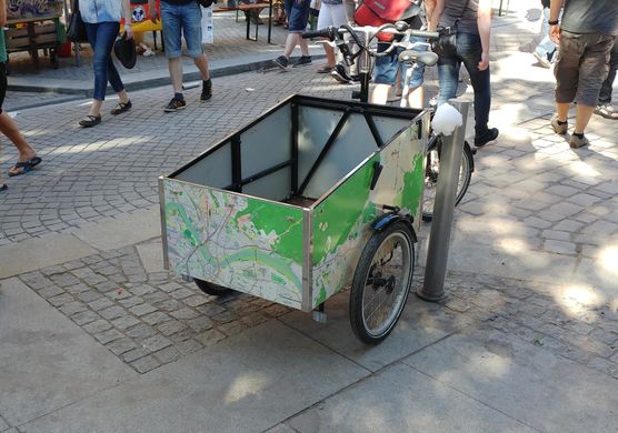
- English : Spotted wheeling the streets of Dresden, Germany, this tricycle has a localised OpenStreetMap design!
- 中文(繁體) : 這輛三輪車在德國德勒斯登被發現,並且還有在地化的開放街圖設計。
第32週(從2017年8月7日星期一到2017年8月13日星期日) [Edit]

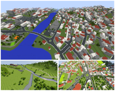
- English : OpenStreetMap data can be represented in the 3D blocky virtual world of Minecraft. See Minecraft for a list of projects to make this conversion. These scenes were created by WorldBloxer.
- 中文(繁體) : 開放街圖資料可以呈現在 Minecraft 裡的 3D 區塊虛擬化的世界中。請見 Minecraft 看看一長串的計畫是怎麼轉換資料。這張圖片的場景是用 http://www.geoboxers.com/worldbloxer/ WorldBloxer] 製作。
第33週(從2017年8月14日星期一到2017年8月20日星期日) [Edit]

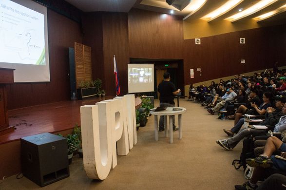
- English : Presenting OpenStreetMap and GPS mapping to an audience of over 100 mountaineers at AkyatCon2.0, the conference of the University of Philippines Mountaineers (UPM).
- 中文(繁體) : 在 University of Philippines Mountaineers (UPM) 舉行的 AkyatCon2.0 大會上,講者向超過 100 位登山客介紹開放街圖和用 GPS 畫地圖。
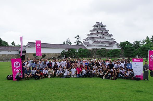
第34週(從2017年8月21日星期一到2017年8月27日星期日) [Edit]

- English : The international OpenStreetMap conference State Of The Map 2017 took place last weekend in Aizu-Wakamatsu, Japan.
- 中文(繁體) : 國際開放街圖大會 State Of The Map 2017 上週末在日本會津若松市舉行。
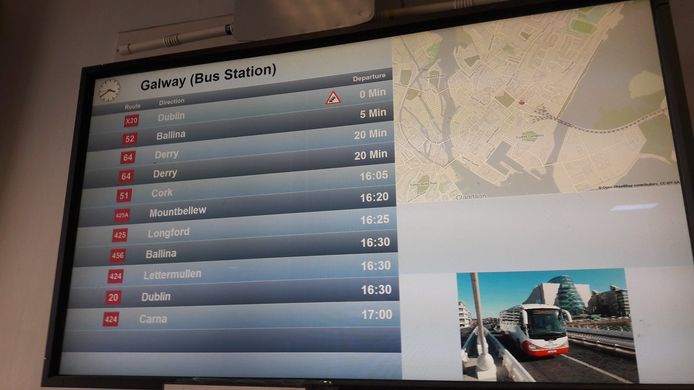
第35週(從2017年8月28日星期一到2017年9月3日星期日) [Edit]

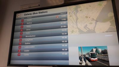
- English : OpenStreetMap in the information screens of the Ireland bus company Bus Éireann.
- 中文(繁體) : 愛爾蘭公車公司 Bus Éireann 資訊螢幕上的開放街圖。
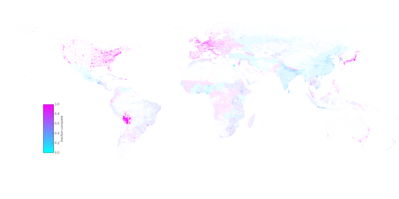
第36週(從2017年9月4日星期一到2017年9月10日星期日) [Edit]

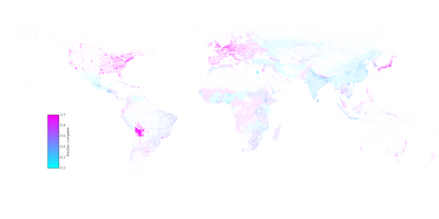
- English : A research article by Christopher Barrington-Leigh and Adam Millard-Ball has undertaken worldwide completeness analysis of OpenStreetMap's road coverage based on visual comparison of imagery and other statistical methods.
- 中文(繁體) : Christopher Barrington-Leigh 和 Adam Millard-Ball 的研究報告,依據影像和其他統計方法的視覺比對,進行全球尺度的開放街圖道路網完整度分析。
第37週(從2017年9月11日星期一到2017年9月17日星期日) [Edit]

- English : In Belarus the OpenStreetMap community came together with the byGIS community for a big gathering with presentations and an OpenStreetMap birthday cake! More details, photos and talk videos on Gardster's OSM diary.
- 中文(繁體) : 在白俄羅斯,開放街圖社群與 byGIS 社團共同合辦有演講和開放街圖計畫生日蛋糕的聚會!
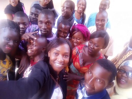
第38週(從2017年9月18日星期一到2017年9月24日星期日) [Edit]

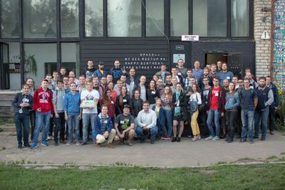
- English : Student group photo at the end of “CartoCamp” at Université de Ségou, Mali.
- 中文(繁體) : 在馬利塞古大學舉行的"畫地圖營隊 (“CartoCamp”) 活動結束後,學生的團體合照。
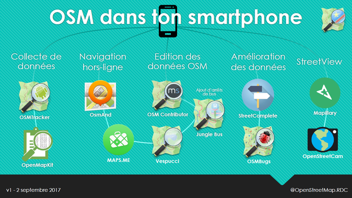
第39週(從2017年9月25日星期一到2017年10月1日星期日) [Edit]

- English : A selection of Android apps for different types of OpenStreetMap contribution and use, presented by Claire Halleux at a recent mapathon in Kinshasa.
- 中文(繁體) : 由 Claire Halleux 在最近的金夏沙圖客趴上,介紹一些不同類型,能夠編輯或使用開放街圖的 Android apps。