Zh-hans:Featured images/Jul-Sep 2017
Jump to navigation
Jump to search


这是特色图片,展现开放街图画地图范例,以及最能代表开放街图的专案。
如果你知道其他有类似品质的图片,你可以在特色图片提名处(en)提名。
| ← 从2016年7月到9月 | ← 从2017年4月到6月 | 从2017年10月到12月 → | 从2018年7月到9月 → |
特色图片库、从2017年7月到9月

2017年、第27周
2017年、第28周
2017年、第29周
2017年、第30周
2017年、第31周

2017年、第32周
2017年、第33周
2017年、第34周
2017年、第35周
2017年、第36周

2017年、第37周
2017年、第38周
2017年、第39周
细节和字幕
第27周(从2017年7月3日星期一到2017年7月9日星期日) [Edit]

- English : With drone pilots, Marines, Navy and Army's Scout Rangers, User:Schadow1 organised a mapping expedition in southern Philippines for logistics, navigation, military operations purposes, and tourism. 1,957 data elements were added by the expedition.
- 中文(简体) : 在有了无人机操作员,海军陆战队、海军以及陆军的侦察游击团的参与下,User:Schadow1 在菲律宾南方基于后勤、导航、军事行动以及旅游的目的,组织地图探察团。这次探查总共增加 1,957 项的资料元素。
第28周(从2017年7月10日星期一到2017年7月16日星期日) [Edit]

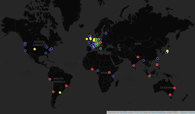
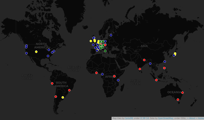
- English : An historical map locating all State Of The Map conferences that took place since 2007. An interactive map is also available, made with UMap.
- 中文(简体) : 一张截至的历史性地图,列出所有全曾举行 State Of The Map 大会地点。另外也有 UMap 版本的 互动地图。
第29周(从2017年7月17日星期一到2017年7月23日星期日) [Edit]

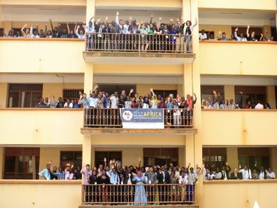
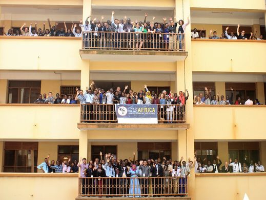
- English : The first “State of the Map Africa” conference took place one week ago in Kampala, Uganda.
- 中文(简体) : 第一次 “State of the Map Africa 大会” 一周前在乌干达坎帕拉举行。
第30周(从2017年7月24日星期一到2017年7月30日星期日) [Edit]

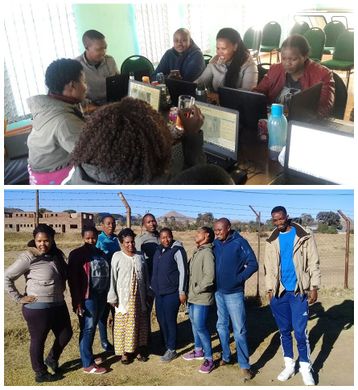
- English : Mzwandile Thokoane from the MapLesotho project, lead a mapping event to bring advanced JOSM mapping back to Hlotse, in Leribe, Lesotho.
- 中文(简体) : MapLesotho 专案的 Mzwandile Thokoane 组织绘图活动,要将进阶的 JOSM 绘图技巧带回赖索托莱里贝区的莱里贝。
第31周(从2017年7月31日星期一到2017年8月6日星期日) [Edit]

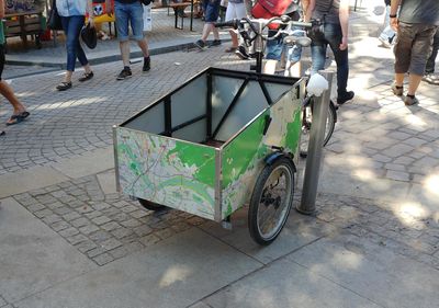
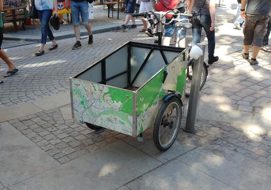
- English : Spotted wheeling the streets of Dresden, Germany, this tricycle has a localised OpenStreetMap design!
- 中文(简体) : 这辆三轮车在德国德勒斯登被发现,并且还有在地化的开放街图设计。
第32周(从2017年8月7日星期一到2017年8月13日星期日) [Edit]

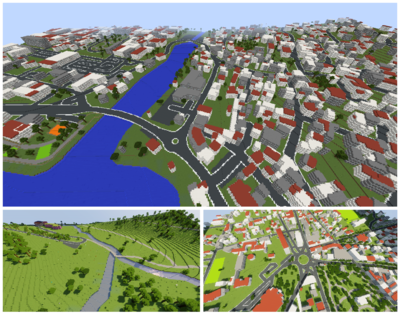
- English : OpenStreetMap data can be represented in the 3D blocky virtual world of Minecraft. See Minecraft for a list of projects to make this conversion. These scenes were created by WorldBloxer.
- 中文(简体) : 开放街图资料可以呈现在 Minecraft 里的 3D 区块虚拟化的世界中。请见 Minecraft 看看一长串的计画是怎么转换资料。这张图片的场景是用 http://www.geoboxers.com/worldbloxer/ WorldBloxer] 制作。
第33周(从2017年8月14日星期一到2017年8月20日星期日) [Edit]

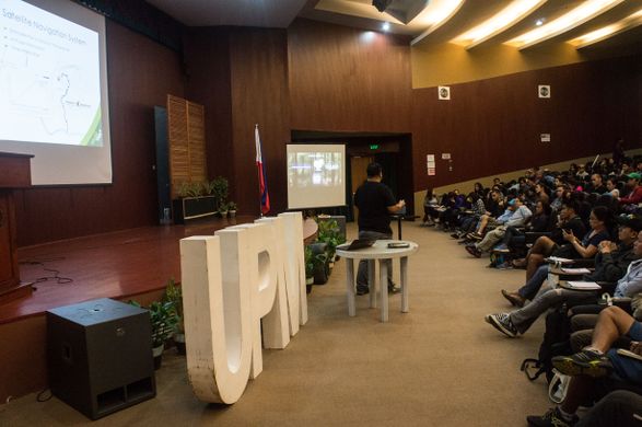
- English : Presenting OpenStreetMap and GPS mapping to an audience of over 100 mountaineers at AkyatCon2.0, the conference of the University of Philippines Mountaineers (UPM).
- 中文(简体) : 在 University of Philippines Mountaineers (UPM) 举行的 AkyatCon2.0 大会上,讲者向超过 100 位登山客介绍开放街图和用 GPS 画地图。
第34周(从2017年8月21日星期一到2017年8月27日星期日) [Edit]

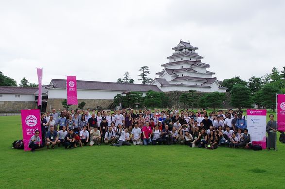
- English : The international OpenStreetMap conference State Of The Map 2017 took place last weekend in Aizu-Wakamatsu, Japan.
- 中文(简体) : 国际开放街图大会 State Of The Map 2017 上周末在日本会津若松市举行。
第35周(从2017年8月28日星期一到2017年9月3日星期日) [Edit]

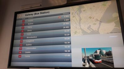
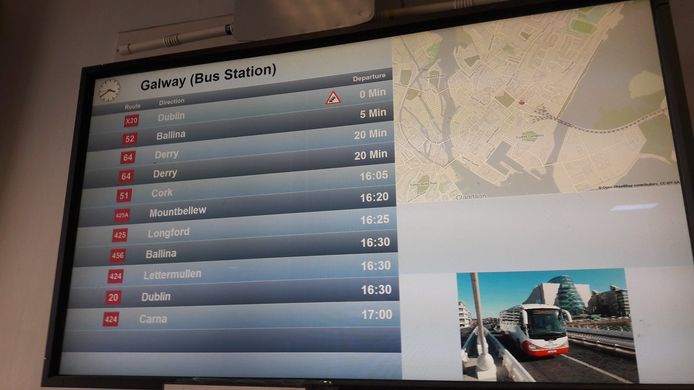
- English : OpenStreetMap in the information screens of the Ireland bus company Bus Éireann.
- 中文(简体) : 爱尔兰公交公司 Bus Éireann 资讯萤幕上的开放街图。
第36周(从2017年9月4日星期一到2017年9月10日星期日) [Edit]

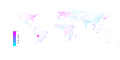
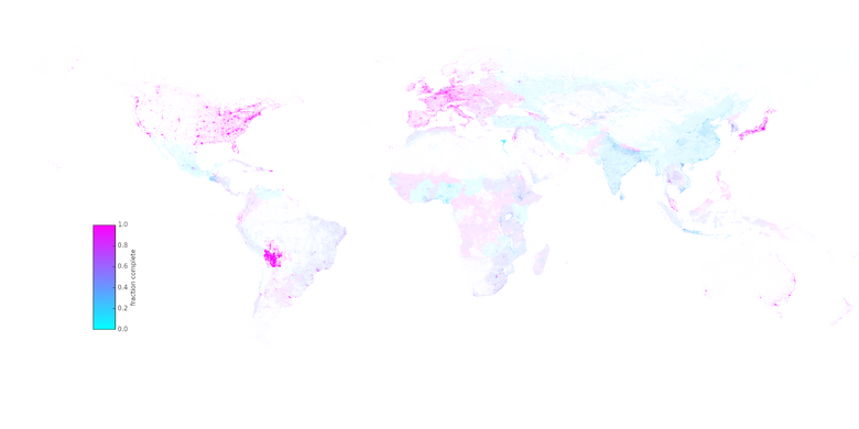
- English : A research article by Christopher Barrington-Leigh and Adam Millard-Ball has undertaken worldwide completeness analysis of OpenStreetMap's road coverage based on visual comparison of imagery and other statistical methods.
- 中文(简体) : Christopher Barrington-Leigh 和 Adam Millard-Ball 的研究报告,依据影像和其他统计方法的视觉比对,进行全球尺度的开放街图道路网完整度分析。
第37周(从2017年9月11日星期一到2017年9月17日星期日) [Edit]

- English : In Belarus the OpenStreetMap community came together with the byGIS community for a big gathering with presentations and an OpenStreetMap birthday cake! More details, photos and talk videos on Gardster's OSM diary.
- 中文(简体) : 在白俄罗斯,开放街图社群与 byGIS 社团共同合办有演讲和开放街图计画生日蛋糕的聚会!
第38周(从2017年9月18日星期一到2017年9月24日星期日) [Edit]

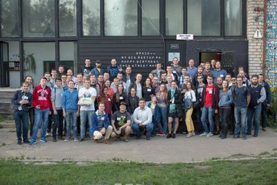
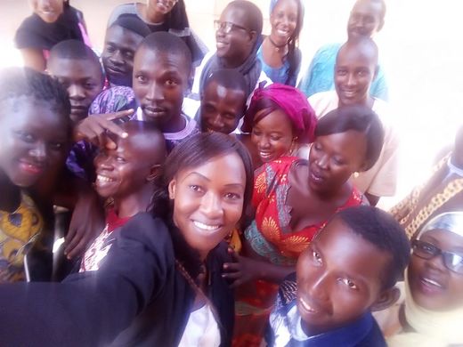
- English : Student group photo at the end of “CartoCamp” at Université de Ségou, Mali.
- 中文(简体) : 在马利塞古大学举行的"画地图营队 (“CartoCamp”) 活动结束后,学生的团体合照。
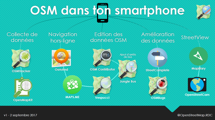
第39周(从2017年9月25日星期一到2017年10月1日星期日) [Edit]

- English : A selection of Android apps for different types of OpenStreetMap contribution and use, presented by Claire Halleux at a recent mapathon in Kinshasa.
- 中文(简体) : 由 Claire Halleux 在最近的金夏沙图客趴上,介绍一些不同类型,能够编辑或使用开放街图的Android apps。