File:Beckton STP, Activated Sludge Tank - geograph.org.uk - 1481906.jpg
Jump to navigation
Jump to search


Size of this preview: 463 × 600 pixels. Other resolutions: 185 × 240 pixels | 494 × 640 pixels.
Original file (494 × 640 pixels, file size: 167 KB, MIME type: image/jpeg)
This file and its description are from Wikimedia Commons.
Summary
| Description |
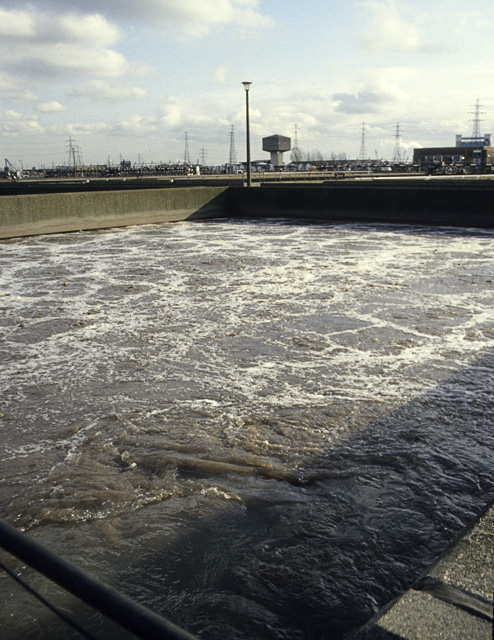
English: Beckton STP: Activated Sludge Tank The primary effluent from the settling tanks (1481890) is now largely free of solid matter, but contains much dissolved organic matter. In these tanks it is vigorously aerated so that micro-organisms can convert this to Carbon Dioxide and Water. From here the liquid goes to 1481916 to settle. The name 'Activated Sludge' refers to the fact that the tanks are seeded with the sludge from the previous generation of activation. See 1481923. |
| Date | |
| Source | From geograph.org.uk |
| Author | John Rostron |
| Attribution (required by the license) | John Rostron / Beckton STP: Activated Sludge Tank / |
| Camera location | | View this and other nearby images on: OpenStreetMap |
|---|
_heading:45.00&language=en)
| Object location | | View this and other nearby images on: OpenStreetMap |
|---|
_heading:45.00&language=en)
Licensing

|
This image was taken from the Geograph project collection. See this photograph's page on the Geograph website for the photographer's contact details. The copyright on this image is owned by John Rostron and is licensed for reuse under the Creative Commons Attribution-ShareAlike 2.0 license.
|
This file is licensed under the Creative Commons Attribution-Share Alike 2.0 Generic license.
Attribution: John Rostron
- You are free:
- to share – to copy, distribute and transmit the work
- to remix – to adapt the work
- Under the following conditions:
- attribution – You must give appropriate credit, provide a link to the license, and indicate if changes were made. You may do so in any reasonable manner, but not in any way that suggests the licensor endorses you or your use.
- share alike – If you remix, transform, or build upon the material, you must distribute your contributions under the same or compatible license as the original.
File history
Click on a date/time to view the file as it appeared at that time.
| Date/Time | Thumbnail | Dimensions | User | Comment | |
|---|---|---|---|---|---|
| current | 14:25, 2 March 2011 | | 494 × 640 (167 KB) | wikimediacommons>GeographBot | == {{int:filedesc}} == {{Information |description={{en|1=Beckton STP: Activated Sludge Tank The primary effluent from the settling tanks (1481890) is now largely free of solid matter, but contains much dissolved organic matter. In these tanks it is vi |
File usage
The following 58 pages use this file:
- Ar:Map Features
- Az:Map Features
- Cs:Key:man made
- Cs:Map Features
- Da:Key:man made
- Da:Map Features
- El:Map Features
- Et:Key:man made
- Fi:Kartan ominaisuudet
- Hr:Key:man made
- Hr:Map Features
- Hu:Key:man made
- Hu:Map Features
- Key:man made
- Pl:Key:man made
- Projet Garrigue
- Pt:Key:man made
- Pt:Map Features2
- Tag:man made=oxidation ditch
- Uk:Key:man made
- Uk:Об'єкти мапи
- Yue:Key:man made
- Zh-hant:Map Features
- Wiki:Files used by data items/3
- Template:Ar:Map Features:man made
- Template:Az:Map Features:man made
- Template:Cs:Map Features:man made
- Template:DE:Map Features:man made
- Template:Da:Map Features:man made
- Template:El:Map Features:man made
- Template:Et:Map Features:man made
- Template:FR:Map Features:man made
- Template:Fi:Map Features:man made
- Template:Generic:Map Features:man made
- Template:Hr:Map Features:man made
- Template:Hu:Map Features:man made
- Template:IT:Map Features:man made
- Template:JA:Map Features:man made
- Template:NL:Map Features:man made
- Template:Pl:Map Features:man made
- Template:Pt:Map Features:man made
- Template:RU:Map Features:man made
- Template:Uk:Map Features:man made
- Template:Yue:Map Features:man made
- Template:Zh-hant:Map Features:man made
- DE:Key:man made
- DE:Map Features
- DE:Tag:man made=oxidation ditch
- FR:Key:man made
- FR:Éléments cartographiques
- IT:Key:man made
- IT:Map Features
- NL:Kaartelementen
- NL:Key:man made
- RU:Key:man made
- RU:Объекты карты
- JA:Key:man made
- JA:Map Features