Key:lock
Jump to navigation
Jump to search
 |
| Description |
|---|
| Marks a stretch of waterway bounded by lock gates, forming a lock. |
| Group: waterways |
| Used on these elements |
| Useful combination |
| Status: approved |
| Tools for this tag |
A lock is a device used for raising and lowering boats, ships and other watercraft between stretches of water of different levels on river and canal waterways by raising and lowering the water level in a fixed chamber.
How to map
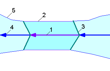
Small lock
- 1. Lock
- Separate the way
 of the
 waterway=*at the two lock gates. Mark the newly created section with
- 2. Gate of a lock
- Place two nodes
 on the main flow line (
waterway=*), where the upper and lower sluice gate is located and mark both
- 3. Channel or river
Large lock

- 1. Lock
- Separate the way
 of the
 waterway=*at the two lock gates. Mark the newly created section with
Tags used at the lock
maxwidth=*maxlength=*draft=*lock_ref=*lock:height=*manual=yes- the lock is operated with muscle powerautomated=yes- the lock is operated by mechanical powerself_service=*- is the lock operated by the crew of the boatself_service=only- the lock must always be operated by the crew of the boatself_service=no- the lock is operated by staff, crew may or cannot operate itself_service=partially- at times, the lock is operated by staff, while the crew must operate it at other times (for example at night)self_service=yes- crew operated, but not further specified
opening_hours=*boat=*ship=*CEMT=*seamark:type=gate
See also
waterway=boat_lift- A boat liftwaterway=dock- A dockwaterway=security_lock- Flood barriervhf=*- VHF channel number to communicate with the lock- Marine Mapping
- Seamarks/Gates#Other Attributes
- lock on Wikipedia
- Not to be confused with:
locked=*,lockable=*
