Proposal talk:Man made=tunnel
Don't use disused|abandoned=yes
I am under the impression this is generally discouraged and should not be used for new features. One of the other alternatives in comparison of life cycle concepts could be handy, my favorite beeing lifecycle prefix. RicoZ (talk) 14:45, 19 May 2016 (UTC)
- Thanks, to simplify this proposal, I'll try to keep out of that discussion and remove the tags from the list of recommended tags. --Biff (talk) 16:02, 19 May 2016 (UTC)
ele=* and 3D mapping
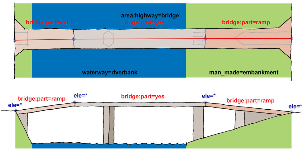
There was some work done on 3D mapping of bridges, I would reuse as much as possible: Bridge3D. Especially it would be useful to allow ele=* on nodes equivalent like in this picture http://wiki.openstreetmap.org/w/images/thumb/4/40/F3DBbridgeWithRampV1description.jpg/975px-F3DBbridgeWithRampV1description.jpg
In this picture the ele values are attached to the nodes of the highway but it might also make sense to attach them to nodes of the outline or any mix of those. RicoZ (talk) 14:55, 19 May 2016 (UTC)
- Thanks. My idea was to provide the possibility for the tagger to simply copy info from traffic signs (like the one shown at the top of the proposal page) or other sources. It is not my intention to forbid the use of ele=* on any nodes. I suppose that 3D renderers would not rely on the simple, single value and rather try to evaluate the nodes. --Biff (talk) 16:07, 19 May 2016 (UTC)
Objects in tunnels, multilevel tunnels
I have done a proposal concerning this and a bunch of other points - Proposed features/Simplify man made=bridge mapping - and most parts should be applicable here. In particular:
- Objects on bridges
- location=bridge instead of bridge=*
- Multi-level bridges
should work in an equivalent way. Please have a look at this proposal and let me know what you think. RicoZ (talk) 15:18, 19 May 2016 (UTC)
- Interesting idea. I prefer it over relations that many mappers find complicated. I'll think about your proposal and comment there. --Biff (talk) 16:13, 19 May 2016 (UTC)
Area highway
Not sure what the status of Proposed features/area:highway is but it should be mentioned. I think man_made=bridge/tunnel can be seamlessly combined with that. RicoZ (talk) 15:50, 19 May 2016 (UTC)
What about separated tunnel tubes?
I think they should be mapped separately? RicoZ (talk) 20:08, 19 January 2019 (UTC)
- Yes, and then you might make them members of a tunnel relation. --Biff (talk) 00:26, 22 January 2019 (UTC)
- Seems wrong after all.Relations/Proposed/Bridges and Tunnels can not group tubes together as it has no matching tube/tunnel member(s) declared and I think they can't be simply added to the table because they would contradict with the "outline" member. RicoZ (talk) 21:51, 31 May 2019 (UTC)
Obsolete Bridges/Tunnels relation?
After looking at various things again I think the relation is pretty useless.. any opinion Talk:Relations/Proposed/Bridges_and_Tunnels#Is_there_still_any_need_at_all_for_this_relation.3F ? RicoZ (talk) 20:21, 23 January 2019 (UTC)
Large Flooded Culverts Mapped as Area
Background: The current standard is to map a culvert as a way (tunnel=culvert & tunnel=flooded). However it is now common to use a very large (steel or concrete) culvert where in the past a bridge would be employed. These can be up to 7m wide & high. They may be permanently, intermittently, or tidally flooded. They are larger than many smaller objects mapped as an area. They are buried in stones and gravel and a road is built on top of the gravel. By function and common definition these are tunnels employed as culverts. These are now used for the passage of small watercraft, so mapping the actual width should allow the navigable route to be mapped along the centreline and improve presentation at high zoom levels.
My question: How should these be mapped? Best Rgds, -H- HMWamboldt (talk) 02:32, 23 June 2022 (UTC)
- What's the question here?
man_made=tunnel+tunnel=culvertworks. However, I assume you may want to ask about individual cells vs the entire box culvert. As proposed in Proposed_features/man_made=tunnel#Cases_that_should_be_tagged_differently,man_made=tunnelcould be used for the entire box ("tubes" refer to the layout of multiple bores, although common language may mix up with cells), while individual cells would usenatural=water+water=*+tunnel=culvert. Kovposch (talk) 04:44, 23 June 2022 (UTC)
My apologies for my lack of clarity. My question is: Is it OK to tag an *area* as man_made=tunnel + tunnel=culvert. According to the wiki, tunnel=culvert can only be used on a *way*. Would the use of the term culvert on an area be considered an error?