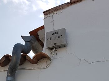
Proposal:Telecom paths proposal

| Telecom paths | |
|---|---|
| Proposal status: | Draft (under way) |
| Proposed by: | fanfouer |
| Tagging: | telecom=path
|
| Applies to: | |
| Definition: | Provide a simple and extensive way of mapping telecommunications cable paths with telecom=path
|
| Statistics: |
|
| Draft started: | 2021-07-19 |
Proposal
It is proposed to use telecom=path to map telecommunication cable pathways defined below, whatever their importance, size, nature or capacity can be.
Such Openstreetmap feature will represent actual paths where an unspecified amount of telecommunication cables are supposed to be installed. It will be done in a more simple way than to map one and each cable laying in those paths.
Some common attributes can be useful to complete visual description of paths:
Rationale
Telecommunication networks are complex arrangements of links and nodes to forward our digital material. Those links often consist in cables, both copper or optical fibre, that go in underground ducts, aerial pathways along utility poles or indoor cable ways. Mapping individual cables can become unbearable on such a common mapping platform like OSM, cluttering many surroundings in dense cities areas as telecommunications literally become obvious.
However, it is possible to define a simpler concept to qualify many different infrastructures supporting utility networks for any purpose: utility paths.
Telecommunication cables paths are the most valuable thing we can map in OSM regarding telecom links. It provides a simpler and an abstracted view of bunches of cables seen in place between poles or underground.
Mappers may be more interested by drawing a single line between two points to state there are cables here without be forced to count, qualify and identify each of them.
This would take advantage of topological capabilities of OSM platform as it's easy to link telecom=exchange, telecom=connection_point and telecom=distribution_point or telecom=data_center nodes with duct ways (both for aerial and underground).
FInally it is consistent with power=line, power=minor_line and power=cable which are intended to map power paths. Despite power tagging also consider actual cables inside power paths, the same path logic applies when it comes to merge several cables or circuits with cables=* and circuits=* over a single given way.
This would furthermore enable anyone to build a more elaborated view of actual cables outside of OSM on top of this robust descriptive base layer.
A passive infrastructure
Such utility paths regard neutral and passive infrastructure which can support many different utilities.
It's a simpler framework to describe utility networks that abstracts the need to get into details (what cable, what pipe, etc.)
As a consequence, it won't be relevant to combine paths and telecom:medium=* here, as both copper and fibre cables can run in the same path.
It's currently not possible to converge toward a completely unified framework describing passive ducts and paths for any utility (especially power and any other cable-based network like railway signalling).
Despite it would be really interesting to define such a generic bunch of concepts, it's currently not possible to replace power=* features running inside the same kind of passive infrastructures.
Just like power=* features imply utility=power, telecom=path will imply utility=telecom.
Capacity of ducts
Capacity management of cable ducts can be very complex as well. Cables may be arranged differently depending on the duct's cross section, duct's sub ducting, diameters and so on.
Currently, professional usage doesn't always involve a normalization taxonomy to document this large diversity of configurations and let this information as free text field undoubtedly lead to a huge mess.
Capacity description to be determined with capacity=*.
A common concept
Despite aerial pathways, underground piping or indoor cable ladders looks like very different, telecom=path feature is intended to group them three under the same concept.
Existing OSM tagging is relevant to make a consistent distinction between them, with the help of location=*.
location=underground: It's an underground pipinglocation=overhead: It's an overhead aerial pathway supported byman_made=utility_polelocation=indoor: It's a cable ladder installed in a building supporting cables in technical ceilings or floorstunnel=yes: Path is located in a larger tunnel.
As it's not recommended to mix power and telecommunications (more generally very low voltage utilities) for safety reasons, OSM should make a distinction between them and map power=cable and telecom=path on separate features.
A large diversity of usable infrastructure
Telecom cables can not only lay in dedicated infrastructures but in a large set of usable third party infrastructures, just like many utilities networks.
It can be economically viable to use inspectable sewers, bridges, underground tunnels for telecommunication roll out and many other features could actually get telecom=path if relevant.
That will mostly be documented by examples and practice.
Tagging
| Key | Value | Description | Use |
|---|---|---|---|
telecom=path |
- | It's a telecommunication cable path | mandatory |
location=* |
underground, indoor or overhead |
Cables duct's location depending if it's underground piping or aerial pathway | recommended |
operator=* |
<Company name> | Company that is responsible of the cable duct | recommended |
material=* |
- | Material composing the duct, relevant for underground and indoor only | optional |
width=* |
- | Width of the cable path, if applicable, mainly for indoor or underground situations | optional |
height=* |
- | Height of the cable path, if applicable, mainly for indoor or underground situations | optional |
tunnel=yes |
- | Used if the cable path is in larger tunnel | optional |
bridge=yes |
- | Used if the cable path is in a bridge | optional |
The use of cables=*, mostly used for power networks isn't relevant here as cables mapping would require many more classification and topological tools we don't have currently and don't want to achieve nor maintain shortly.
It is possible to use line_arrangement=* on specific nodes (not on the way itself) to define what geometrical configuration the path actually have. General guidelines for arrangement applies here and you may find more information on the key's page directly.
Edition management
Affected pages
- Create
telecom=pathpage and describe what is a telecom path - Discourage
communication=line
Values to be replaced
| Obsolete tag | Usage | Used for ? | New tag(s) to use |
|---|---|---|---|
communication=line |
12 803 on 2024-04-29 | A single communication cable | telecom=path
|
Examples
Overhead telecommunications
| Photo | Location | Tagging | Note |
|---|---|---|---|
 |
Switzerland |
On way:
|
An overhead telecom path on which uninsulated telephone landlines are installed between poles |
 |
North America | Several telephone, CATV and optical fibre cables cross on an utility pole. Two OSM ways should be drown crossing at the pole and following the cables. |
Underground telecommunications
| Photo | Location | Tagging | Note |
|---|
Undersea telecommunications
| Photo | Location | Tagging | Note |
|---|---|---|---|
 |
USA |
On ways:
|
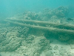
Two cables sharing the same path undersea. |
Vote
Vote hasn't started yet