Tag:building=riding_hall
 |
| Description |
|---|
| A building that was built as a riding hall or indoor arena. |
| Rendering in OSM Carto |

|
| Group: buildings |
| Used on these elements |
| Useful combination |
| See also |
| Status: in use |
| Tools for this tag |
A ![]() riding hall, indoor arena, indoor school (UK English), or indoor ring (US English), is a building that was specially designed for indoor horse riding.
riding hall, indoor arena, indoor school (UK English), or indoor ring (US English), is a building that was specially designed for indoor horse riding.
The tag can also be used for ![]() lungeing halls.
lungeing halls.
How to map
Place a node ![]() in the centre of the building or draw an area
in the centre of the building or draw an area ![]() along its outline.
along its outline.
Tag it with building=riding_hall.
Use as a riding hall
building=riding_hall only describes the type of the building and not if it is really used for indoor horse riding. A building that was built as riding hall may later be used for something else, and buildings of other types may also be used for indoor horse riding.
If a building is actually used as a riding hall add leisure=sports_hall + sport=equestrian [1]
The area used for riding inside of the hall (often smaller than the whole building) can (optionally) be mapped as a separate object (node ![]() or area
or area ![]() ) with
) with leisure=pitch + sport=equestrian + indoor=yes. It is discouraged to combine building=* with leisure=pitch, compare indoor pitches.
Examples
Exterior views
-
 Altenhorst - DE
 -
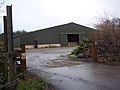 Pembroke - UK
 -
 Vienna - AT
 -
 Prague - CZ


Interior views
-
 Sindlingen - DE
 -
 Palaiseau - FR
 -
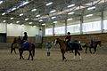
 Dublin OH - USA
 -
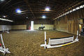
 Bábolna - HU
.jpg)

.jpg)

Tags to use in combination
See also
building=barnbuilding=industrialbuilding=roofbuilding=sports_centrebuilding=sports_hallbuilding=stablebuilding=tentbuilding:use=*leisure=horse_ridingleisure=pitch- Riding