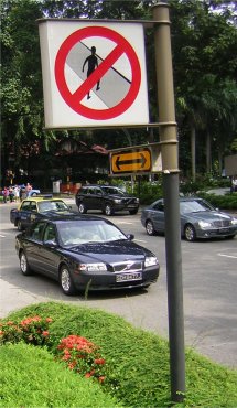
Tag:crossing=no
Jump to navigation
Jump to search
 |
| Description |
|---|
| Where crossing is not suitable, possible or legal. Used at places where one would expect a crossing, but there isn't one. |
| Group: crossings |
| Used on these elements |
| Status: approved |
| Tools for this tag |
Tagged at nodes where it is not suitable, possible or legal to cross. The tag is used at places where one would expect a crossing, but there isn't one.
Notes:
crossing=noexcludes the existence of a crossing and therefore must be used withouthighway=crossing.crossing=nocan make sense both in countries where "jaywalking" is forbidden and where it is legal (see for example https://www.openstreetmap.org/node/255456310 https://www.openstreetmap.org/edit?editor=id&node=255456310#map=20/52.42878/-1.93580 where crossing may be legal but there is no marked crossing).
Examples

|
A place with a traffic light (highway=traffic_signals) but without a pedestrian crossing.
|

|
Illegal railway crossing (text on the sign: “illegal railway crossing, 2 people died here and 2 were injured”). In such a case the railway/path intersection node can be marked with crossing=no.If there is a highway=footway it needs access=no to make clear that it should not be used (for example in routing).
|
Another case may be where the geometry of a footway crosses a way of a road, but at that position, it is not possible, legal, or eligible to cross, so pedestrians (or routers) need to find the closest proper crossing to safely continue onto the footway on the other side of the road.