Tag:leisure=swimming_area
| Description |
|---|
| An area for swimming within a larger body of water (such as a river, lake or the sea) that is marked by a rope, buoys or similar |
| Rendering in OSM Carto |
| Group: leisure |
| Used on these elements |
| Useful combination |
|
| See also |
| Status: de facto |
| Tools for this tag |
|
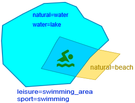
A swimming area is an officially designated and marked place where you can swim in a body of natural water such as a reservoir, river, lake, or the sea. The markings might by signs, buoys, or a netted enclosure.
Note that this tag should only be used to map the part of the water that's designated for swimming, and should not include surrounding areas (like the beach or any facilities). Historically, this tag has been used as the "primary" tag for a bathing place by some mappers, but this usage is discouraged, and existing such cases should be adjusted to also include an object tagged with leisure=bathing_place, leisure=beach_resort or amenity=public_bath (see Disambiguation).
Though uncommon, it is theoretically possible for a bathing place/beach to have more than one swimming area, for example, one that is off-limits for children and one that is open to all, or segregated by gender.
How to map
Draw the outline ![]() of the water area. Add leisure=swimming_area.
of the water area. Add leisure=swimming_area.
If there is a lifeguard on duty, add either a node for emergency=lifeguard if they are in a fixed location; or, if they are mobile, add lifeguard=yes to the area.
If there are no lifeguards in the area, include lifeguard=no.
Tags used in combination
- sport=swimming
- supervised=yes/interval
- lifeguard=*
- salt=*
Example
Note however, that this should not be mapped as a leisure=swimming_area (leisure=swimming_pool would probably be more appropriate):
Disambiguation
A swimming area should never be mapped on it's own. It should always be "part of"/"belong to" (though this does not imply that their elements have to intersect or for there to be a relation between them):
See Swimming and bathing for a comparison of these tags.
- natural=beach - A beach is the natural occurrence, disjoint from whether swimming is suitable
- leisure=swimming_pool - When not in natural water
When not to map
Keep in mind the Verifiability rule: You should only map a leisure=swimming_area if there is some way to verify the outlines. Usually, this will be a line of buoys or similar. The physical outline does however not have to be continuous; for example, single buoys in the corners or lines of buoys that only extend straight out from the beach can be considered sufficient, if they clearly imply the complete outline.
Do not map the entire lake/reservoir/other body of water. If there is no verifiable marking that designates where swimming is allowed/suitable then no swimming area should be mapped.
Also, be aware that there are beaches where the markers are moved regularly (sometimes as often as multiple times daily) according to weather and other factors[1]. If this is the case the swimming area should not be mapped, as it would violate the "don't map temporary features"-rule. However, if it is possible to tell the full extent within which the swimming area is moved then that area may be mapped, even if the actual swimming area at any point in time only is a part of this.
See also
- leisure=beach_resort - a managed beach, including within the boundary any associated facilities. Entry may also require payment of a fee
- natural=beach - unvegetated strip of sand, shingle or other loose material at the coast or the shore of a lake
- emergency=lifeguard - a place where a lifeguard is on duty
- amenity=public_bath - a location where the public may bathe in common
- leisure=water_park - an amusement park with features like water slides, recreational pools (e.g. wave pools) or lazy rivers
- leisure=swimming_pool - A swimming pool constructed to hold water for swimming in.


