United States/Trails Stewardship Initiative
The OSM US Trails Stewardship Initiative is a community effort to ensure responsible mapping of trails on recreational lands in the United States. This project is a collaboration between the OpenStreetMap US mapping community, US land management agencies at the federal, state and local levels, and developers of popular outdoor navigation apps that use OSM data. Want to get involved? Consider joining the Trails Working Group.
Background
On September 22, 2021 Keri Nelson, a backcountry coordinator for the US Park Service presented a "Mappy Hour" presentation titled "Trails in OpenStreetMap". The presentation described the damages that have resulted from visitors hiking through backcountry areas and sensitive sites outside of designated hiking trails. Backcountry enthusiasts have used maps and apps sourced from OpenStreetMap data to find and navigate trails in US national parks and public lands that are not designated as part of the park's managed trail system and not listed on official maps.
Park Service representatives cited the following issues:
1. Closed/unmarked trails rendering the same as or more strongly than official/managed trails: On several OSM-based maps and/or hiking apps, examples were cited in which closed, illegal, or non-existing trails were rendered exactly the same as, or more prominently than the marked trail system managed by the park service. This created an expectation amongst park visitors that these trails were of a similar access and character to other trails in the park.
2. Trails marked in locations where there is no trail: In some cases, trails were marked in locations where there was no trail physically on the ground. In the photo below, a route terminates at a steep canyon wall; a mapper had marked a trail up the canyon wall face where no trail exists.
3. Social trails mapped to posted dangerous areas or off-limits sensitive sites with illegal access Of particular concern to the Park Service are that hikers have created "social trails" to sensitive sites and mapped these on OpenStreetMap. This has encouraged other hikers to follow these trails, causing damage to the important locations.

Non-official trails in Canyonlands National Park
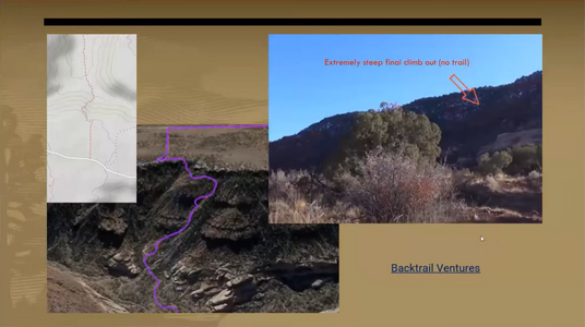
Trail marked along a steep scramble where no trail exists

Hikers illegally accessing sensitive sites via "social" trails


Nomenclature
This project uses the following terminology:
- Official Trail - A trail which physically manifests on the ground and is marked, blazed, or signed by the land owner/manager. In cases where the the trail passes over wear-resistant surfaces such as bare rock, the trail may be manifested only by markings such as cairns, paint blazes, or signs. Official trails are normally marked in trail maps published by the land owner/manager.
- Social Trail - An unmarked but physically manifested path created by repeated use by pedestrians or hikers as a shortcut or in order to access a location away from another trail.
- Closed Trail - A trail which physically exists, but access to the trail is permanently prohibited by the land manager/owner and marked or signed as closed. These trails might be used, for example, for land access by land managers but not open to the general public. This does not include trails that may be temporarily or seasonally closed.
- Way - A line drawn in OpenStreetMap that is used to represent a trail or path.
Analysis
- OpenStreetMap is an open database of geospatial information. In order for park trails to render in the desired way, they must be accurately tagged so that renderers can decide which trails to show, which trails to not show, and which trails to emphasize or de-emphasize. Marking trails a certain way in OpenStreetMap should not be seen as an alternative to physically marking trail access rules on the ground.
- Neither the community of mappers, nor the United States chapter of OpenStreetMap (OSM US), nor the global OpenStreetMap Foundation (OSMF) control the decisions made by the authors of various maps and applications. Even if trails are appropriately tagged, it may still be required to work with the individual developers of these products to achieve the desired user-facing outcomes.
- Even with good data, and good rendering, each application sets its own frequency for how often the map is updated. Applications may take days, weeks, or months to update after a change is made to the map.
Lessons from land managers
The Trails Working Group has benefited greatly from the participation of many federal, state, and local land management agencies. Here are some of the things we've learned from them.
- Participation in outdoor recreation has grown significantly over the past few years [1] (accelerated in part due to the COVID-19 pandemic which limited opportunities for indoor activities). Many land managers were operating with limited staff and budget prior to this recent growth trend, and are now struggling to manage the larger number of visitors to their parks. [2]
- Official trails on public land may look like they formed naturally, but in fact they are carefully engineered. There is a science and art of trail design [3]. A well-designed trail is built to withstand the expected type and amount of visitor traffic, to shed rainwater without eroding, and to guide visitors along the desired path and avoid encouraging unwanted behaviors (like cutting switchbacks or walking beside the trail, which can cause widening).
- More visitors to a park may mean more revenue (from entrance fees, campground reservations, or wilderness permits). But it also has a slew of negative effects:
- Increased traffic on trails can damage the trails and the adjacent landscape. Trails that see more traffic than they are designed for tend to become wider. In alpine environments, a faint trail may become a braided net of trails if there is a surge in use. Steep trails erode more quickly, and under heavier traffic may become so eroded that they are dangerous to walk on.
- More visitors means more human impacts on the landscape. This includes human waste, litter, air pollution from vehicles, graffiti, and noise pollution (which drives away wildlife). And this challenge compounds, because the visual presence of litter or other impacts causes a breakdown of social norms, and makes people more likely to contribute to the problem themselves. [4]
- Overcrowding causes poor experiences for visitors: packed trails, noisy campgrounds, traffic jams in parking lots, and long lines at entrance stations and restrooms. This makes people less likely to return to a park (and less likely to recommend it to others). If left unmanaged, this leads to the "trampling herd" problem: overuse of a desirable location damages the location and makes it less desirable (the location is sometimes said to have been "loved to death"), which then causes people to go elsewhere and repeat the cycle.
- There has been a dramatic increase in search and rescue (SAR) operations in many National Parks, greater than proportional with the increase in visitation. Many land managers believe this is the result of information about unofficial trails and routes being more widely available on the internet, including in OpenStreetMap. Many apps do not visually distinguish between official and unofficial trails, or between easy trails and very difficult trails. This can result in unprepared visitors attempting to hike the trail and getting lost, stuck, or injured (even killed).
- Similarly, there has been an increase in damage (accidental and intentional) to fragile and culturally sensitive archaeological sites on public lands. One factor contributing to this is that the locations of these sites can easily be found online and in many cases in OpenStreetMap. Even if an archaeological site itself is not mapped, an unofficial spur trail that leads to it may have been, and visitors who see this trail on their map may investigate it. Land managers attempt to protect these sites through education (e.g. signs on the ground asking visitors not to disturb the site) but they cannot anticipate which previously off-the-beaten-track locations may suddenly become overrun, due to e.g. exposure on social media or suddenly appearing on third party maps.
- Land managers have many methods of managing visitation. They can limit visitor numbers (through timed entry systems or permits), encourage dispersal away from overcrowded areas, or develop infrastructure that can handle the additional traffic (improving trails, installing guideposts and warning signs, etc). But they are dealing with an unprecedented growth in outdoor recreation, while at the same time dealing with the fact that many people are getting their maps and information from sources that the land management agencies don't control.
- OpenStreetMap volunteers can help protect our public lands by ensuring that trail data in OSM is accurate; in particular, adding tags to distinguish between official and unofficial trails, and also adding other attributes such as trail difficulty (e.g. SAC scale) and trail visibility. When this data is present, renderers can use it in their maps, and visitors can make informed choices about where to go when recreating on public lands.
Plan of action
Proposed is the following plan of action:
| Phase | Actions Taken | Roles |
|---|---|---|
| 1. Establish tagging standards |
|
|
| 2. Execute nationwide park trail tagging campaign |
|
|
| 3. Continuous monitoring of trail renderers |
|
|
Suggested Tagging
| Situation | Tagging |
|---|---|
| An official trail |
|
| A closed trail |
Access values describe restrictions on the use of paths. Add access=no to a trail (such as a highway=path) to signal that it is off-limits. For trails that are additionally in a degraded state, consider adding a lifecycle prefix to the highway=* key, such as disused:highway=path or abandoned:highway=path depending on the situation. |
| A social trail, and access to this social trail, or social trails in general, is prohibited by the land owner/manager.
(as evidenced by posted signs or markings, or by text on e.g. the official website or visitor maps) |
|
| A social trail, and access to this social trail is not prohibited outright, but is officially discouraged by the land owner/manager.
(as evidenced by posted signs or markings, or by text on e.g. the official website or visitor maps) |
|
| A social trail, and access to social trails is not prohibited or discouraged by the land owner/manager | |
| A trail leaving public land for private property where the landowner does not allow access by the general public. | |
| There is no trail at this location, but mappers have marked a way via a "bushwhack" and it is unlikely that another mapper would mark a trail here. |
|
| There is no trail at this location, however, future mappers might mark a trail here due to factors of topography, geography, or the Strava heatmap. |
|
OverpassTurbo-Query to display official (green), informal (yellow), discourage informal (orange), forbidden informal (red) and private (grey) paths.
Additional tags to consider
| Characteristic | Tagging |
|---|---|
| Trail Visibility: How easy it is for an average person to locate and follow such trail. Trails with low visibility are more likely to be social trails, cause visitor to either get lost or enter areas with restricted access. It is therefore important distinguish them from official trails. | |
| Trail Difficulty: How demanding it is for and average person to move along the trail. Trails with steep slope, unstable surface or obstacles are more likely to cause serious accidents. Marking trail difficulty helps to better distinguish paths for visitors with different levels of experience. | |
| "Stages of decay" lifecycle prefixes: Useful for indicating that a trail has fallen into has become overgrown, fallen into disrepair, or been removed. These prefixes can generally be applied to any class of trail (for example, a heavily overgrown trail could be tagged disused:highway=path, regardless of whether it is official or informal and whether access to that trail is allowed). See Lifecycle prefix for a complete list of available prefixes. |
Trail Tagging Chart

Suggested rendering and recommendations to data consumers
How trail information gets rendered by apps has a large influence on users when visiting natural areas. Indiscriminate rendering of all trails can cause risk of conflicts with private owners when moving on land that not intended for public use, damage to protected environment and cultural heritage, or serious injury. To limit such risks, we can adjust how is OSM data is represented on a map or inside a routing algorithm.
In the ideal case, the most prominent path features on a map are Official Trails, which can be identified by the Way representing the trail having a type=route + route=hiking relation or not containing access=private;no or informal=yes tags.
Closed trails, Social trails or Private trails are best not shown at all. However, sometimes showing such trails can help orientation in terrain or help in emergency situations. In such cases, rendering of these trails should be substantially less prominent or clearly marked as inaccessible, e.g. with X marks or displaying text PRIVATE/CLOSED.
Below is an example of a rendering decision tree distinguishing between designated official trails, unmarked/unofficial trails, social trails, and non-public/closed trails. Map makers will make varying choices about how exactly to render these trail types depending on the purpose of their map. For some purposes displaying only designated official trails may be best. For others, including all types may be appropriate. Ideally designated official trails should always be most prominent, with other types displayed less prominently if included.

See also
- Hiking
- Trail markings
- Proposed features/Social path
- Past community discussions:
- US National Park Service Tagging: Trails
- Australia/Walking Tracks