JA:Key:cycleway
| 説明 |
|---|
| 車線内または車線のわきにある自転車通行帯や自転車道です。 |
| グループ: 自転車道 |
| 適用できる要素 |
| 文書化された値の数: 6 |
| 含まれる意味 |
| 状態:事実上の標準 |
| ツール |
英語版の記事の内容が分かる方は、翻訳の完成にご協力ください。このウィキの翻訳方法についての説明をお読みください。
現時点では、誰もこの記事の翻訳に取り組んでいないようですので、あなたが取り組めます。
道路に付属している自転車道をマッピングするには、 highway=* に cycleway=* タグを追加します。これは道路の一部として存在する「自転車通行帯」に特に適用するものであり、また道路の隣に並行している場合には独立した「自転車道」にもよく適用されます。
自転車通行帯
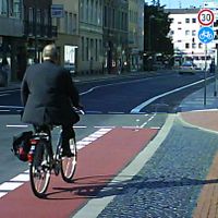
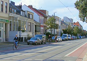
自転車通行帯(or class II facility)は道路そのものの一部です。他の車線から物理的に仕切る縁石のようなものなく、道路標示のみで区切られています。空間や分離標(ラバーポール)のみがあり物理的に分離されていない場合、buffered bike laneと呼ぶこともあります。
専用の自転車通行帯
- 主な記事:JA:順方向と逆方向・左側と右側
- cycleway=lane
- cycleway=lane は、両側に自転車レーンのある双方向の道路、あるいは一方通行の道路で車道と同じ方向の自転車レーンのある場合に使います。
- 代わりに、右側または左側にある自転車レーンにはそれぞれcycleway:left=laneとcycleway:right=laneタグを使うことを考慮してください。
- "right"と"left"はエディタ上でJA:ウェイが描かれている方向(たとえばiDエディターではウェイの中点にある矢印がその方向です)に対する左右であり、現実世界での進行方向と必ずしも一致しないことに留意してください。
- 自転車の通行は道路の同じ側の交通と同じ向きに許されていると仮定すべきです(これはoneway=yesの道路では、道路の両側で自動車と同じ向きになります)。
- 国によっては自転車通行帯に2種類があります: 自転車専用の厳格に分離されたものと、そうではなく通常点線で示されるソフトに分離されたものです。この2種類の自転車通行帯を区別するために、cycleway:lane=exclusiveまたはcycleway:lane=advisoryを追加することができます。サイクリストは普通は専用レーンの方を好みますので、この区別を記録することは経路検索に有用です。
- cycleway=opposite_lane
- 逆行自転車レーン、つまり一方通行(oneway=yes)の道路で他の交通とは逆向きの自転車レーンがある場合には、cycleway=opposite_laneを使います。
- 注: この値には問題があります。opposite*についての問題を参照。
Consider using the cycleway:left=opposite_lane or cycleway:right=opposite_lane tags instead, as this describes on which side the contraflow lane is.- As the discussion on Talk:Key:cycleway:left shows,
opposite*are not valid values for cycleway:left=* and cycleway:right=*.
Use oneway:bicycle=no together with cycleway:left=lane and/or cycleway:right=lane, instead. See above for how OSM uses 'right' and 'left', which may not be the same as the real-world usage.
- As the discussion on Talk:Key:cycleway:left shows,
- These roads should normally also be tagged with oneway:bicycle=no.
- cycleway=opposite with oneway:bicycle=no
- 一方通行の道路で、専用の逆行レーンがないけれども自転車は双方向に通行できる状況ではcycleway=oppositeを使います。
- 注: この値には問題があります。opposite*についての問題を参照。
- In practice there is typically a very short section of road, sometimes called a "cycle plug", where cycles are excepted from the no-entry by means of a short lane and/or a short track that is separated by an island.
- These roads should normally also be tagged with oneway=yes and also oneway:bicycle=no.
- Streets like this are common in Belgium, the Netherlands and Denmark. They are less common in the UK, but have become increasingly frequent following a change in road signage that now allows 'no entry' signs to be qualified with "except cycles".
共用の自転車通行帯
- cycleway=shared_lane
- 自転車が動力車両と車線を共用しており、共用する旨の標示があります。
- この
 sharrowと呼ばれる道路標示は、通常、自転車の通行ルートを強調したり、運転手に対して自転車が通行することを知らせたりするためのものです。
- In Netherlands and Belgium in particular, the tag is also used to indicate suggestion cycle lanes (fietssuggestiestrook(Wikipedia)). To distinguish between the two, it can additionally be tagged with cycleway:lane=pictogram for sharrows or cycleway:lane=advisory for suggestion cycle lanes respectively.
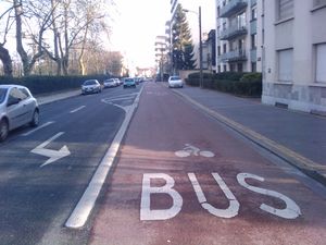
- cycleway=share_busway
- 公共交通機関のための専用レーンで、自転車も通行できるもの。
- cycleway=opposite_share_busway
- On a oneway=yes road, this is a special contraflow lane that is reserved for public transport on which cyclists are also allowed to bike in the opposite direction to general traffic.
- 注: この値には問題があります。opposite*についての問題を参照。
Consider using the cycleway:left=opposite_share_busway or cycleway:right=opposite_share_busway tags instead, as this describes on which side the contraflow shared bus lane is.- As the discussion on Talk:Key:cycleway:left shows,
opposite*are no valid values for cycleway:left=* and cycleway:right=*.
Use oneway:bicycle=no together with cycleway:left=share_busway and/or cycleway:right=share_busway, instead.
- As the discussion on Talk:Key:cycleway:left shows,
- These oneway=yes roads should also be tagged with oneway:bicycle=no. Also tag with oneway:bus=no, or instead use oneway:psv=no if taxis are also permitted to use the contraflow bus lane.
- これは以前segregated=*タグが定められるより前に、highway=cyclewayでタグ付けされる独立した自転車道にも使われていました。自転車道に対して使うことは旧式のやり方だと考えられています。 purpose-built cycleways are assumed to be shared.
自転車道
自転車道は縁石、駐車帯、緑地帯、街路樹などの物理的障壁によって道路からは分離されているが、道路の隣に並行しているものです。北米ではprotected bike lane, separated bike lane, bike path, greenway, green lane, class I facilityなどと呼ばれています。
自転車道は道路の隣に独立のウェイを描き highway=cycleway[1] でタグ付けすることもできます。2つの手法にはそれぞれ長所と短所があります。既存のウェイに1つタグを追加するのは手間もかからずたいていは十分正確に自転車道を記述できますが、独立したウェイのほうがより柔軟性がありより詳細を捉えることができます(複雑なぶん、経路エラーの可能性も増しますが)。自転車道を独立したウェイとしてマッピングする場合には、以下で説明するタグを'使用しないでください。
独立して描いた自転車道を一般の道路と正しく接続することは極めて重要です。事実を反映させるということもそうですが、経路決定アルゴリズムは、距離が1mも離れていないとか、ウェイが交差しているけど接続するノードがないといったことを、「理解」したりイチかバチか決め打ちしたりできないので、これを助けるという意味でも重要です。
- cycleway=track
- その道路に関連する自転車道の存在を示します。自転車通行帯と同様、道路の(エディター上でウェイが描かれている方向に対して)どちら側に存在するのかを示すために cycleway:left=track と cycleway:right=track を使うことができます。
- cycleway=opposite_track
- Use cycleway=opposite_track for a contraflow cycle track, that is, a cycle track travelling in the opposite direction to other traffic on a oneway=yes road.
- 注: この値には問題があります。opposite*についての問題を参照。
Consider using the cycleway:left=opposite_track or cycleway:right=opposite_track tags instead, as this describes on which side the contraflow track is.- As the discussion on Talk:Key:cycleway:left shows,
opposite*are no valid values for cycleway:left=* and cycleway:right=*.
Use oneway:bicycle=no together with cycleway:left=track and/or cycleway:right=track, instead.
- As the discussion on Talk:Key:cycleway:left shows,
- These roads should normally also be tagged with oneway:bicycle=no.
他の値
- cycleway=asl
- 交差点における
 advanced stop line(二段停止線)またはbike boxを示します。道路のウェイ上で停止線の位置にノードを置き cycleway=asl を使います。最寄りの交差点を探して停止線を適用する向きを判定するのはデータ利用者に任されますが、代わりに direction=forward や direction=backward を使って明示することもできます。
- cycleway=shoulder
- 自転車で高速な車道を通行することが現実的には困難な場合で、合法的に路肩を通行可能であることを示します。これは標識によって(たとえば"Motor Vehicles and Bicycles Only."のように)示されています。
- cycleway=separate
- その道路に関連した自転車道が別個の要素としてマッピング(つまり highway=cycleway でタグ付け)されていることを示すために利用可能です。あまり使われていませんが、sidewalk=separateと同様の意味で、描画を単純化するのに利用できます。また道路に cycleway=track を加えることで既存の自転車道と重複することを防ぐヒントとしても働きます。cycleway=sidepathと同様の意図があります。segregated=yesと混同しないでください。
- cycleway=no
- 道路に自転車用施設がないことを示します。ほとんど全てのウェイに追加することで益なくタグリストを汚染することになりますが、しかし自転車用施設を実地調査したことを明示することが可能になります。
- cycleway=<user-defined>
- 他に使われている値についてはSee taginfoを参照してください。
Problems with opposite* values
opposite*という一連の値は、oneway:bicycle=*や左右を示す接尾辞があまり使われていない頃に考案されました。しかしタグ付けシステムは進歩しています。
議論ページ(英語版)が示すとおり、opposite*という値は、向きと施設を1つの値で表しており、道路の両側に異なるタイプの施設があることを表現できません。
よりよい代替案は、oneway:bicycle=no を cycleway:left=* や cycleway:right=* と一緒に用いることだと思われます。議論ページ(英語版)を参照してください。
注: Talk:Key:cycleway:leftについての議論が示すように、opposite* はcycleway:left=* や cycleway:right=* に対して有効な値ではありません。which is another point for consistently using :left and :right instead of opposite*.
追加の詳細
自転車通行帯や自転車道を道路のウェイにタグ付けする場合、cycleway:をJA:名前空間接頭辞として使うことができます。これはタグ付けされる詳細情報を自転車道部分のみに限定する意味を持ちます。この名前空間はさらに :left, :right, :bothの接尾辞と組み合わせて cycleway:both=*, cycleway:left=*, cycleway:right=*のようなタグを作り出すことができます。
- cycleway:surface=paving_stones
- cycleway:right:surface=asphalt
- cycleway:smoothness=good
- cycleway:foot=designated
- cycleway:right:width=3
- cycleway:left:width=2.5
現在のところ、地図描画ソフトウェアなどのデータ利用者が広く理解しているものではありません。舗装状態などの高度な情報、とりわけ自転車道のものについては、自転車道を道路に並行する独立した![]() ウェイとして描くことを検討してください。highway=cyclewayを参照のこと。
ウェイとして描くことを検討してください。highway=cyclewayを参照のこと。
関連情報
- JA:自転車
- Bicycle tags map
- JA:サイクリングルート
- United Kingdom National Cycle Network
- London Cycle Network
- JA:順方向と逆方向・左側と右側
外部リンク
 Bike lane
 Bikeway safety - a measure of how protected a bike lane is from other traffic, could be a possible data value to inform planning
| ||||||||||||||||||||||||||||||
- ↑ または highway=path + bicycle=designated


