Talk:Key:cycleway
Cycleways / lanes / tracks
Moved from Talk:Map_Features
I'm curious about the correct use of values for the key Cycleway. As I understand it, a lane is a dedicated strip on the main road surface to be used mainly/only for riding bicycles on. A track would be road surface separate from the main road running alongside it. Then there are corresponding values for lanes and tracks in the opposite directions. Are the definitions I use correct? What if a residential road has cycle lanes in both directions (given that no key has more than one value)? Or cycle tracks 10 meters from the main road? --Benbono 22:35, 4 April 2007 (BST)
- "road has cycle lanes in both directions": if it is on the border on the road, you have the value "lane". It is the same like the car on a highway, one highway for two directions.
- "cycle tracks 10 meters from the main road": it must be a separate track. You should use key "highway" with value "cycleway". OnTour 21:37, 29 May 2007 (BST)
Cycleways on the left and right
So if there's a cycleway=* on both sides of the road, should it be tagged as e.g. cycleway=track;opposite_track? I'm assuming so for now. A related question: I'm assuming that cycleway=opposite_* isn't dependent on the status of oneway=*. Am I right here? --achadwick 23:03, 11 May 2008 (UTC)
- I am not, by the looks of Hawkes's recent edit. Apparently opposite_* is dependent on oneway=yes, and thus should be used for what's called a "contraflow cycle lane" in the UK (but only the ones on oneway streets). This is a mess. Additionally, cycle lanes and the bicycle parts of shared-use pavements/sidewalks here almost always have directionality, and more often than not can only be found on one side of the road, going in the same direction as the carriageway they're next to for safety reasons. The current scheme does not reflect the fact that the cycleway often only applies in one direction. --achadwick 12:57, 4 June 2008 (UTC)
- I'm definitely not the final authority on the cycleway tag, so tag as you will. :-) Previous use has suggested that the opposite_ values are for contraflow lanes (and tracks?), and that which side of the road the track or lane is on is left undefined for now. So keep in mind that any method for documenting that will be new. It should probably consider: a bike lane or track, going with or against traffic, on one side or both sides. --Hawke 17:01, 4 June 2008 (UTC)
- Indeed, frequently in the UK, the cycle lane stops and starts repeatedly along a major road. The cycleway=lane convention surely couldn't support this, as it is a feature of an entire road/street. I notice that in London, cycle tracks parallel to the road are often used to indicate cycle lanes which stop and start. I suppose that is the only way for now, but breaks the convention that a cycle track is off-road. --davespod 13:31, 14 October 2008 (UTC)
- You could split such road into segments where the lanes start/stop, tagging the segments accordingly, with or without cycleway=lane.
Combining with :left and :right
It's not a perfect solution, but Proposed features/right left is mostly compatible with the existing scheme. Here's what we might do to fix this mess:
| Value | |||||
|---|---|---|---|---|---|
| lane | track | opposite_lane | opposite_track | ||
| Key | cycleway:left | On-road bike lane down the left-hand side* for with-flow cycle traffic (only?). | Off-road cycle track down the left-hand side* of the road. Typically segregated from motor traffic, but typically not from pedestrians. For with-flow cycle traffic (only?). | On-road, on the left*, against-flow (only?) | Off-road, on the left*, against-flow (only?) |
| cycleway:right | As above, but on the right-hand side of the road* | ||||
| cycleway | As above, but applies to both sides of the road at once (incl. oneway?) | ||||
* reckoned with reference to the Way's direction arrow.
I'd also like to remove the requirement that opposite_* only be applied to one-way streets, state that plain lane and track allow only with-flow traffic, and create a 5th and 6th category of bidirectional_{lane,track} to cover cases where the lane or track can be traversed in both directions. Rendering engines have all the details they need to render cycleways nicely right there on the way itself: highly advantageous for lanes. Routing engines have all they need to know about for making bike routes too. Double win! (admittedly at the cost of some extra complexity). I think that's mostly it for physical characteristics, with the possible exception of width (cycleway:width[:left|:right]=<metres>, perhaps?) --achadwick 02:29, 22 February 2009 (UTC)
- In my opinion, all
opposite*can be deprecated in favour of cycleway:left=* and cycleway:right=*, see Deprecate cycleway opposite
All these values are not needed with :left/right or even invalid --Skyper (talk) 17:42, 10 September 2020 (UTC)
Osmarender bug?
I am mapping some divided suburban arterials with bake lanes, coded as pairs of one-way secondary and tertiary highways with cycleway=lane. Osmarender renders light green stripes not only on the outsides of the roads where the bike lanes exist, but also on the insides, next to the median strip between the roadways, where we actually have the fast lane for cars but no bike lane. Is there a particular combination of tags that would cuase the bike lanes to get rendered correctly? Or should I just ignore the bug as it applies to rendering only?
Rendering :left or :right
Neither cycleway:left=track nor cycleway:right=track appear to render in any layer. Are they supposed to? Or is it just easier to add the cycleway as a separate way along side the way for the highway?
- They *currently* don't render (in Mapnik). They should and they will someday. One should never make mapping decisions based upon what and how the rendering engine renders, one should always map for the database's sake. Therefore, when applicable, always use the cycleway=* semantics, instead of redrawing a parallel cycleway (which *loses* the information of being part of the same road domain.
Indicating when you are obliged to use the cycleway
In Germany, the presence of a road sign indicates that you have to ride on the cycleway (interesting in the case cycleway=track. Any suggestions on how to tag this? cycleway:compulsory=yes/no? Robx 17:26, 26 July 2008 (UTC)
- In Austria, every cycleway (no matter if track or lane) has to be used in any case. I'd suggest to leave it like with highway=living_street and state that the tag is implicit according to the rules of the country. E.g., in Austria, one would have to tag all highway=crossing that have crossing=uncontrolled (for bikes) with maxspeed=10 for the bicycles. -- MapFlea 14:40, 11 November 2008 (UTC)
- I think that doesn't work in Germany. If I understand the situation correctly then it's only compulsory if accompanied with a specific sign, which is by no means used on every cycle lane. Randomjunk 15:38, 11 November 2008 (UTC)
- in that case highway=cycleway would always be compulsive because it's designated for bicycles (predominantly indicated by signs). If there is no special indicated/designated way it's just a "path + bicycle=yes" or you have to use ne normal carlanes of a road, because e.g. in Germany you are not allowed to use "path + foot=designated -> highway=footway" (e.g. sidewalks) if it's not additionally allowed. --Cbm 06:28, 12 November 2008 (UTC)
- So, then as a conclusion (summary): In Germany, highway=cycleway shall be used for dedicated bicycle tracks where usage is compulsive, cycleway=track on itself stands for both (compulsive or not). In Austria, cycleway=track is enough as all cycleway=* combinations are compulsive on their own. Is this summary correct? -- MapFlea 07:12, 12 November 2008 (UTC)
- highway=cycleway = cycleway=track. cycleway=track just means that a "designated cycleway" follows the road. It would be se same as tagging a seperate way right next to the normal road-way. Only cyclway=cyclelane could both depends on how you tag "Schutzstreifen" which are no designted bicycle-lanes and have no compulsive use. Designated bicyclelanes have afaik compulsive use just like autark cycleways; they are just intgrated in the normal road-surface. (Also see: http://wiki.openstreetmap.org/index.php/DE:Germany_roads_tagging#Fu.C3.9F-_und_Radweg) --Cbm 07:38, 12 November 2008 (UTC)
A late addendum. I'm moving the recently (Feb 2013) added
Legal access
To distinguish cycleways, where bicycles have to ride on, from cycleways, which can be used but also the highways, you can use cycleway:bicycle=designated/yes. So in the UK for a cycle lane with solid lane, mandatory usage, you tag: cycleway=lane+cycleway:bicycle=designated, and for a cycle lane with a dashed line, advisory usage : cycleway=lane+cycleway:bicycle=yes. For other vehicles the tags can be used in the same manner.
to here from the main page because this seems like the right section. It seems to have a misinterpretation of the UK "mandatory" designation for cycle lanes: in Britain, a "mandatory" cycle lane is one which motor vehicles must not enter. Conversely the first sentence seems to be about distinguishing compulsion on cyclists from an absence of compulsion on cyclists. Additionally it seems to me to require a specific definition of access=designated which is not actually the case. Additionally, the tag is not in very widespread use, so while the wording is this unclear and the definitions this vague, let's discuss it here.
--achadwick (talk) 19:17, 28 May 2013 (UTC)
- As the author of this section I want to give my reasons. Mainly I was thinking about the situation in Germany as described above. If there is this
 ,
,  or this
  sign you have to use the cycleway. And if I look at the end of Tag:access=designated I can see all signs with bicycle=designated. So I was assuming that the situation in the UK is similar. That seems to be wrong as there are sometimes no signs. But one can also add cycleway:motor_vehicle=no :). So the example from the UK was wrong.
 - The consequences for me are the following: In Germany we can add the Tag cycleway:bicycle=official instead of cycleway:bicycle=designated if the cycleway is compulsory. In the UK one can use cycleway:motor_vehicle=no for mandatory designation and cycleway:motor_vehicle=yes for advisory. If there are signs the appropriate tags should be used.--Balgofil (talk) 09:26, 1 June 2013 (UTC)
- I just learned about access=official myself. From the definition, it's correct to use it the UK for any cycle lanes with an official sign erected nearby, or the official Drawing no. 1057 painted on the road (frequently rather poorly!) by the council's road workers. But what a mess! Another layer to the access tagging, and it's still impossible to distinguish between must-use and for-exclusive-use internationally.
- Given this problem, I'm not certain it makes sense to tag access levels for cycleways using the current tags. At least, not to address this problem. If a data consumer must still refer to local law to decide, e.g., whether a motorbike can use a cycle lane (and what classes of motorcycle), then it's simpler to just tag as cycleway=lane or whatever and let the data consumer software decide. We can still tag the exceptions to the national or regional rule with explicit tags (I like this approach; it has a sort of mindfully lazy Zen quality to it).
- This of course assumes that almost all cycleways in a country or geographical region share the same law with only a few (<5%, perhaps) exceptions. They might not. If it's more like 40:60 or 50:50 we may have to be more rigorous than I like. Is that the case in Germany?
- --achadwick (talk) 20:56, 3 June 2013 (UTC)
- I think it is easier to tag all things explicitly. Then the situation is also clear for persons who don't know the law in the country. If the access for different vehicles is tagged explicit one can also distinguish between must-use and for-exclusive-use. But I think we should assume a default value for cycleways, e.g. cycleway:bicycle=designated. That should apply for all countrys. Because for routers across borders it is hard to know every special cycling law and of course OSM is an international project.
- For Germany it depends in which Bundesland you are in. In Berlin most of the blue signs where removed after some complaints against the mounting of the sign. But I know in other states it is different.
- --Balgofil (talk) 11:09, 8 June 2013 (UTC)
Basics
Being a newbie I'm lost in the basics I guess. Are cycleway=lane and cycleway=track an additional tag for the roadway itself or should it tag a separate path adjacent to the roadway? --Miriat 12:34, 18 November 2008 (UTC)
- adding cycleway=lane or cycleway=track to the road is more than sufficient. If you have time to kill you can draw separate highway=cycleway next to the road (plus all connections to the road from the cycleway), but IMHO OSM isn't built to handle that well and GPS tracks usually aren't good enough to be able to draw those tracks correctly. --Eimai 13:03, 18 November 2008 (UTC)
- Their separation can be assessed from mapping photos, i.e. "here the cycleway (centerline) on the left is one estate car's length from the road centerline, but there it avoids a tree by going one car length more to the side". The result is as accurate as the road itself - with several traces they both can be some meters offset but their relative distance to each other is even more accurate than that. But often it's really sufficient to just add the tag to the road, especially on the first pass of mapping. Alv 13:17, 18 November 2008 (UTC)
- Do you know any roads that are tagged that way which I could look at as an example? Are they handled well by the renderer (i.e. the cycleways are visible at least in cyclemap)? --Miriat 09:51, 21 November 2008 (UTC)
Here in Denmark we have many roads where the road and cycle path are seperated by a curb, just like a sidewalk. I can't quite figure out whether these paths translate to cycleway=track or cycleway=lane. For a while I've considered cycleway=lane to be when the road and cycle path are only seperated by paint on the ground, while cycleway=track was when a curb or similar barrier seperated them - but now I'm not sure anymore. How do other people tag these? --Jesper Cheetah 03:35, 4 April 2009 (UTC)
- I switch from lane to track merely by the existance of a curb, hedge or other material of more than 30cm width between the road and the cycleway. The rule of 30cm can be stretched of course... The lane is a directly embedded 'cycle'-way on another road, by means of painting a set of extra lines on the street, tracks have more distance to the road it belong to. --ivom 18:42, 26 April 2010 (UTC)
Rendering wish list
In Oxford, we'd like/need to be able to show cycle lanes on one side of the road only, preferably using something like cycleway:left=lane or cycleway:right=lane.--RichardMann 08:34, 8 February 2009 (UTC)
- Formalising this right now: Proposed features/right left, show your support! --achadwick 01:50, 22 February 2009 (UTC)
We'd also like to be able to show the pinchpoints, perhaps using cycleway=squeezed for roads with a fair amount of traffic (ie highway=primary) and kerbside traffic lanes of under about 4 metres. To be rendered as a red cycle lane.--RichardMann 23:23, 9 February 2009 (UTC)
- Partly hinted at by traffic_calming=choker and traffic_calming=chicane, at least for cycleways in the main carriageway. I'd suggest using a different tag to cycleway. There's narrow=* and width=* too, for cycleways that are off-road. Finally, you could invent something like cycleway:hazard=pinch or cycleway:hazards:left=90_degree_bend provided you document it :) --achadwick 01:50, 22 February 2009 (UTC)
- Dutch guidance has defined terms tight/spacious/critical, so maybe those would work better than squeezed. These only really apply if there's no cycle lane / track, so attaching them direct to cycleway seems reasonably efficient, and wouldn't require multiple tag values terribly often. Even if you did have multiple tag values, it's unlikely a renderer would want to display more than one anyway. Narrow traffic lanes go on for hundreds of metres, so are akin to cycle lanes, not point hazards.--RichardMann 14:58, 25 February 2009 (UTC)
Cycleway=no
I think that a value of 'no' should be added to the list of values. Omitting a cycleway tag is ambiguous as to whether there is no cycleway or if it was simply left off. --DanHomerick 17:23, 24 September 2009 (UTC)
I agree. We have some dual-carriageway intersections here in Tampa there is a bicycle lane approaching the intersection from, say, the south, but none for the first block or two as you depart the intersection to the north, with the lane then reappearing. Tagging these blocks with "cycleway=no" is especially helpful because one would expect to find a bike lane but none exists. At least you let the cyclist know that something needs to be watched for.--EdH 16:58, 5 January 2011 (UTC)
Cyclestreet
I have started to use cycleway=cyclestreet in combination with highway=residential or highway=unclassified to mark what is called a "fietsstraat" in Dutch. There is a proposal for highway=cycleroad, but that generated a bunch of opposition. Besides a Dutch "fietsstraat" is sufficiently different from a German "Fahrradstrasse" that I think that proposal doesn't fit. --Cartinus 12:51, 13 December 2009 (UTC)
Cycleways on pavements
What should I do about shared pedestrian and cycle pavements following the road? That's obviously not cycleway=lane, but cycleway=track seems to imply a road surface and not the elevated pedestrian surface. I often seen signs indicating that pavements are permitted for use by cyclists in the UK either with a blue background, white bicycle rectangular sign - or a circular blue background, white symbol sign showing pedestrian and cyclist. Then sometimes the pavement is divided with a solid white line to segregate cyclists and pedestrians. That seems to suggest that cycleway=pavement should exist. --Pink Duck 13:17, 21st January 2010 (UTC)
- No, cycleway=track tells only that the cycleway is separated from the vehicular section by anything from a curb stone to several meters of scrub. Personally, I think it's better to draw all (signposted or not) cycleways as separate ways with highway=cycleway. The white line you mention, separating pedestrians and cyclists, yields a segregated=yes. Alv 08:58, 22nd January 2010 (UTC)
- Then the cycle track description "Road (UK) or path (USA, Canada) dedicated to cyclists on separate right of way" at Bicycle#Cycle_tracks conflicts. In the UK there are segregated road-level tracks for cyclists as well as paths designated for use by cyclists. The distinction would inform cyclists about whether they can expect to encounter pedestrian traffic. --Pink Duck 17:34, 22nd January 2010 (UTC)
Going from opposite to bicycle:oneway=no
I propose a change in the tagging scheme for streets that are oneway for vehicles but not for bicycles. The use of opposite is documented in the wiki as the way to go, but in the cases I know of there is no markings on the street showing where cyclist should be. Thus there is no cycleway in or on the street. Instead two sub-signs are placed on either end of the street depicting cyclists are allowed to go both ways. For this kind of streets the tag to be used should tell something about a restriction a positive one for cyclist in this case. Tag these kind of streets like this oneway=yes, bicycle:oneway=no The tags opposite_lane and opposite_track are useful, when there are markings to segregate the main road with the cycleway.--ivom 20:56, 2 February 2010 (UTC)
- Wouldn't it make more sense to use oneway:bicycle=no for that? See also talk page for oneway=*--Kurt Roeckx 14:10, 18 April 2010 (UTC)
- I took the approach to look at the sub-signage in these streets as a negative restriction that applies to bicycles alone, therefor the name-space starts with bicycle (not cycleway). --ivom 18:44, 26 April 2010 (UTC)
- It's not really necessary to change something that is used 15.000x worldwide so you can assume that this tag is well accepted from mappers ... --Mueck 00:31, 6 August 2010 (BST)
In this day, cycleway= opposite is more used than bicycle:oneway=no cycleway=opposite 38 659 https://taginfo.openstreetmap.org/tags/cycleway=opposite oneway:bicycle=no 13 976 https://taginfo.openstreetmap.org/tags/oneway:bicycle=no bicycle:oneway=no 577 https://taginfo.openstreetmap.org/tags/bicycle:oneway=no --Agaric (talk) 11:00, 8 August 2014 (UTC)
As of begin 2020, oneway:bicycle=* is used about twice as much as cycleway=opposite, 107 136 versus 53 726 times.
Looking at the usage over time, see Talk:Key:oneway:bicycle, you see that oneway:bicycle usage is rising with > 10 000 entries per year while cycleway=opposite is almost flat, so cycleway=opposite is slowly becoming deprecated. -- Emvee (talk) 09:58, 26 January 2020 (UTC)
- I agree. Oneway:bicycle=no should never combine with cycleway=opposite, and cycleway=opposite is an unneccessary tag. A cycleway is suppposed to be a seperate way. If there is a seperate cycleway in the opposite direction it should be tagged seperate from the adjacent road. That leaves cycleway=opposite as an outdated tag.
- Oneway:bicycle=no will however benefit from the additional opposite-tag to indicate the presence of a seperate lane in the form of cycleway=opposite_lane.-- Noordfiets (talk)
- In my opinion, all
opposite*can be deprecated in favour of cycleway:left=* and cycleway:right=*, see Deprecate cycleway opposite
- In my opinion, all
In this case, cycleway:left=lane/track are better alternatives. --Skyper (talk) 17:42, 10 September 2020 (UTC)
Hazards?
How would I tag a hazard, such as a bike lane in the door zone? --NE2 04:31, 25 April 2010 (UTC)
- No one has started the task of collecting and classifying different hazards, so the best option so far is the free form hazard=*, proposed twice: Proposed_features/Hazard_warning and Proposed_features/hazard. Alv 10:54, 25 April 2010 (UTC)
Australian "standards:" Doorlane
These come in bicycle logos under/next to parked cars without a shoulder line, or bicycle logos under/next to parked cars with a shoulder lane.
Obviously this is different to cycleway=shoulder in NSW on long freeway / motorway grade roads.
Depending on the road structure I either tag these as cycleway=shared_lane, or with no infrastructure and (if actually existent) a route relation. Samuelrussell (talk) 03:37, 29 September 2014 (UTC)
- Internationally, cycleway=shared_lane means that there are bike pictograms on the lane and no marked limit between cycling space and car space, see short information of Thunderbay (Ontario) and U.S. Manual on Uniform Traffic Control Devices (MUTCD), 2009 Edition: Chapter 9C. Markings, last section and wikipedia.
- Where similar principles are used in a contraproductive way, consider inventing a different tag!
- A different tag would also be useful for Dutch suggestion lanes, coloured without pictograms and sometimes with a dashed line, which have a similar legal status, too, but tell cyclists "keep very much right!" instead of "use the lane!", see in Nederland.
- There is a proposal & discussion on a more specific tagging of cycling facilities on the road, see Proposed_features/cycleway=soft_lane.--Ulamm (talk) 08:22, 29 September 2014 (UTC)
- This is still a cycleway=lane because there is a solid painted line between the traffic and bicycle lanes. The additional tag cycleway:lane=doorzone is being used when the cycle lane is in the door zone. --Aharvey (talk) 22:11, 5 January 2020 (UTC)
NEV / golf cart lanes?
How would I tag the fact that a public street has a lane dedicated for golf carts (this one is right next to another lane dedicated to bicycles)?
Street-legal golf carts are apparently also called NEVs (probably for Neighborhood Electric Vehicle), at least in California. Sun City Roseville has separate golf cart lanes and bike lanes. Sun City Lincoln has combined NEV and bike lines. I understand the accessibility depends on the speed limit, and in some cases cities have to apply a certification or exception or something from the DMV. Is there any difference besides the names?
Integrating (Cycle/Foot)ways
I'd like to discuss a principle matter on this page. Within OSM we can tag everything on every methode we like. We're free as hell. ;) Nevertheless IMHO every part of the road that has the same name should be mapped/tagged a simple as possible. Therefor a road can consists out of a vehical/cycle/pedestrial part. One way (line) should be sufficiant to tell OSM where those parts are laying. The main tags should be: highway=*
Additional to this (if highway <> cycleway/footway) cycleway=* and/or footway=*
In this simple way you have tagged the existance of the different parts of one street that all carry the same name.
There still is the a problem that some features on the cycleway/footway part of the road conflicts with the same feature on the vehical part of the road. Already discussed example is the oneway=* feature. To solve this problem it is already mentioned as: cycleway:oneway=* (footway mostly do not respond on oneway features.) cycleway:surface=paving_stones footway:surface=grass
In this way the OSM community can - tag both cycleways and footways on a consisant way without extra mapping - Render more easy and more readable maps.
Please react on this view and please forget for a moment that is will be a lot of work to redo all the existing separate mapped cycleways.
-- There is a proposal coming which will combine your idea with the left/right proposal. For now see the Advanced Tagging scheme
- This would cause problems when mapping a cycleway that ends at a sidewalk (example). If the sidewalk is mapped as part of the roadway, how do you indicate that there's no direct access to the roadway from the cycleway? --NE2 21:23, 15 December 2010 (UTC)
- I can't not really see what is what on the picture, but we have solved some of those problems with tags on the node. For example bicycle:crossing=no. We are still not really sure if that is the best solution. But were does that cycleway leads to? It starts at a sidewalk?
- Which leads to: when routers a building the routing graph and know about those tags, they end up constructing (hopefully) the same network that the mapper could have drawn themself, and which would (already) have been visually inspected to be correct. With current tools it's far from trivial to construct the crossing ways, say, at an intersection: it seems the tools would need to look at several nearby nodes for those tags before deciding which connections to add and which to suppress. Alv 07:55, 16 December 2010 (UTC)
- I can't not really see what is what on the picture, but we have solved some of those problems with tags on the node. For example bicycle:crossing=no. We are still not really sure if that is the best solution. But were does that cycleway leads to? It starts at a sidewalk?
- Yes, the cycleway ends at a sidewalk (footway): http://www.openstreetmap.org/?lat=28.654172&lon=-81.340925&zoom=18&layers=M
- I also question how you propose to include length information when the sidewalk curves back and forth and is thus significantly longer than the road. And what happens when there's something between the sidewalk and road, like a fountain? --NE2 22:36, 15 December 2010 (UTC)
- Haha, how fun is that. No one can use that path. For a cycling router it is a dead end. I assume you can't (read: are not allowed to) ride on the sidewalk. But your point of a fountain is a valid one. The intention is to make it easier to map 'tracks' or 'lanes', but it is still very well possible to map a sidewalk or cycleway as a separate way. For example this situation: http://maps.google.nl/?ie=UTF8&ll=52.06699,5.111175&spn=0.007479,0.01929&t=h&z=16&layer=c&cbll=52.067018,5.111359&panoid=WJVQgpzPVqRL7wKIhpAqIw&cbp=13,71.89,,0,5.4. There a cycleway=track is very usefull, there will be only one bridge instead of three. Furtermore, there is, not yet, a need to map the in between parts. And with our proposal the bus lane can be described to.
- Actually in Florida (and most U.S. states) you can ride on the sidewalk if you yield to pedestrians, unless the city prohibits it.
- As for bus lanes, there's one next to a road in Orlando, with sidewalks between the road and the bus roadway in places (mainly to reach bus stops). --NE2 23:42, 15 December 2010 (UTC)
- Three bridges on a/the rendered map is a rendering issue, and IMO a very bad reason to include extra turns into the cycleway. Looking at that location in osm one would have to misrepresentatively alter the shape of the cycleways to connect them to the "main" highway way (as it's at the centerline) with the cycleway:left etc. tags. Albeit a surprising setup, even to a law-abiding citizen that cycleway ending at the sidewalk is not a dead end, the distance to walk with your bike to the next crossing can be a fair trade for the increased safety/decreased stress/saved distance vs. a route on along the roads. Alv 07:55, 16 December 2010 (UTC)
- You can actually ride on the sidewalk. It's still stupid. --NE2 23:33, 16 December 2010 (UTC)
- Please, whenever there short discontinuities in otherwise bicycle friendly itineraries, try to use "bicycle=dismount", whenever this true, to indicate that it still possible to pass though. This indicates its slower and less attractive than an alternative route with "bicycle=yes". Similarly for "barrier=cycle_barrier", please add a "bicycle=dismount" (or else "bicycle=permissive" if you can actually zig-zag through) - the fact is that "cycle barriers" are usually meant to completely stop motorise traffic including motorbikes, generally only slow non-tandem bike traffic a little bit, as well as making a statement about their acceptance, "Hey cyclist, kindly please avoid killing pedestrians beyond this point!". Rarely do they actually stop cyclists, and generally this is quite deliberate, and so the cycle_barrier default of "bicycle=no" is misleading. --Neil Dewhurst, Lyon France (talk) 10:00, 25 July 2014 (UTC)
- Haha, how fun is that. No one can use that path. For a cycling router it is a dead end. I assume you can't (read: are not allowed to) ride on the sidewalk. But your point of a fountain is a valid one. The intention is to make it easier to map 'tracks' or 'lanes', but it is still very well possible to map a sidewalk or cycleway as a separate way. For example this situation: http://maps.google.nl/?ie=UTF8&ll=52.06699,5.111175&spn=0.007479,0.01929&t=h&z=16&layer=c&cbll=52.067018,5.111359&panoid=WJVQgpzPVqRL7wKIhpAqIw&cbp=13,71.89,,0,5.4. There a cycleway=track is very usefull, there will be only one bridge instead of three. Furtermore, there is, not yet, a need to map the in between parts. And with our proposal the bus lane can be described to.
Naming separated cycleways
Sometimes we have really stand-alone cycleways through the country. Sometime they have a kind of name. Using highway=cycleway; name=<nameofthecycleway>. Sometimes there's also the need to draw a track like it is stand-alone cycleway. A kind of Cycletrack (no tag available). I see two difficulties: 1) What name should have this cycletrack (track in cognito ;) ) 2) What do I do to make it clear that the cycletrack belongs to the raod next to it and that routing software will lead me (as a cyclist to the houses that's part of the street.--ZMWandelaar 12:42, 16 December 2010 (UTC)
Left, Right, Forward, Backward?
Correct me if I am wrong but the choice of left/right depends on the direction in which the way is drawn (after all ways can be considered as arrows). On the Access page they suggest the use of "forward" and "backward" for the same purpose. Neither are that easy for mappers to use as it requires the people to realise how ways are essentially arrows, and then the mapper has to determine which way the arrow is pointing (something that I currently struggled to do in Potlatch2 - I hadn't realised that the arrow next to the bin indicates the direction)!
My concern with right / left is that some may think "ok we drive on the right side of the road so it must be cycleway:right" (similarly left for countries such as the UK that drive on the left side of the road). A quick look on TagInfo reveals:
- cycleway:right=* - 9190 occurrences
- cycleway:left=* - 4329 occurrences
A way has a 50/50% chance of being drawn in either direction so (unless people are reversing ways as they prefer right to left) then you would expect the split to be closer. --RobJN 15:54, 17 May 2012 (BST)
- Could the distinction be that for the physical attribute it is best to describe which side of the road it is actually on, and for routing one normally thinks only about which directions in which one can go and the routing engine isn't that bothered about which side of the road it is on. Using left and right for the lane certainly makes it easier for renderers to put the path of the correct side of the road without knowing about the direction of travel in the road. PeterIto 21:42, 28 October 2012 (UTC)
- I confirm that some people (i.e. myself) do indeed verify/reverse the way direction so as to privilege use of cycleway:right. But there is a reason for doing so!
- Living in continental Europe, and so mapping principally for drive-on-the-right roads, then cycleway:right is the normal side for "forward" traffic. This is probably the case for a majority of mappers, from the Americas or living on the Old Continent.
- One-way streets are now extremely common in European towns where car traffic has reached an intensity that would never have been dream-able at the time when streets were "planned". In fact, not withstanding use of reverse direction bus and/or cycling lanes, "one-way systems" are often deliberately used to make car access to town centres, or though-traffic in residential neighbourhoods, complicated, slow and generally bothersome. Thus "encouraging" use of public transport (since many years) and/or bicycles (recent in France, but better established in Germany for example). Hence the logic, for "one-way" streets to set the forward direction so as to (always) use oneway=yes, thus avoiding oneway=-1 which is too easily confusing when working on existing ways. There may still be
cycleway:left=opposite+oneway:bicycle=no,cycleway:left=opposite_lane+oneway:bicycle=no or elsebusway:left=opposite_lane+oneway:psv=no+cycleway:left=opposite_share_busway+oneway:bicycle=no for such streets. But apparently not enough to even up the statistics... - --Neil Dewhurst, Lyon France (talk) 16:57, 23 July 2014 (UTC)
- Edit:
opposite*are no valid values forcycleway:left=* and cycleway:right=*. --Skyper (talk) 14:40, 15 September 2020 (UTC)
- Edit:
opposite*are no valid values forcycleway:left=* and cycleway:right=*.
In my opinion, all opposite* can be deprecated in favour of cycleway:left=* and cycleway:right=*, see Deprecate cycleway opposite --Skyper (talk) 17:42, 10 September 2020 (UTC)
cycleway:right and cycleway:left Mapnik 'bug'
I have removed this comment from the article lead because it doesn't seem to be accepted as a bug by the Mapnik team:
- Note: cycleways tagged using the described cycleway:right and cycleway:left tags are currently not rendered in Mapnik (see bug #2195).
-- PeterIto 21:56, 28 October 2012 (UTC)
"Translation for routing" section
Moved here, since this is way too technical to go on the main page.
The cycleway=opposite* tags can be translated (for routing purposes) to this generic system as follows (oneway restrictions presumably do not apply to pedestrians):
- oneway=yes + cycleway=opposite* to vehicle:backward=no + bicycle:backward=yes
- oneway=-1 + cycleway=opposite* to vehicle:forward=no + bicycle:forward=yes
- oneway=yes + oneway:bicycle=no to vehicle:backward=no + bicycle:backward=yes
- oneway=-1 + oneway:bicycle=no to vehicle:forward=no + bicycle:forward=yes
--achadwick (talk) 11:04, 7 June 2013 (UTC)
Bus and cycle lanes
- This goes against the normal way of classifying ways in OSM. Bus is usually considered bigger and more important than bicycle (it's bicycle allowed on busway, not bus allowed on cycleway...). We should rather tag it as busway=share_cycleway.
-- this whole topic should first be discussed on the talk/discussion page before being added here
- Notes
- Substitute lanes:bus with lanes:psv if taxis can use the lane as well.
- Descriptions are for left-hand driving countries for sake of simplicity. For right-hand driving countries, replace left with right and vice versa.
| Keys | Direction of other traffic | Description |
|---|---|---|
| cycleway=opposite_share_busway lanes:bus:backward=1 |
One-way | There is a contraflow bus and cycle lane running in the opposite direction against other traffic on the right-hand side of a one-way road. |
| cycleway=share_busway lanes:bus=1 |
One-way | There is a bus and cycle lane running in the same direction as other traffic on the left-hand side a one-way road. |
| cycleway:right=share_busway lanes:bus:right=1 |
One-way | There is a bus and cycle lane running in the same direction as other traffic on the right-hand side of a one-way road. |
| cycleway=share_busway cycleway:right=share_busway lanes:bus=1 lanes:bus:right=1 |
One-way | There is a bus and cycle lane running in the same direction as other traffic on both sides of a one-way road, such as at Procter Street |
| cycleway:left=share_busway lanes:bus:forward=1 |
Two-way | There is a bus and cycle lane on the left-hand side of a two-way road. |
| cycleway:right=share_busway lanes:bus:backward=1 |
Two-way | There is a bus and cycle lane on the right-hand side of a two-way road. |
| cycleway=share_busway lanes:bus=2 |
Two-way | There is a bus and cycle lane on both sides of a two-way road. |
We could either go by a top down structure (bus is most important in general opinion - hence tag it busway, taxiway, cycleway) or we could tag busway & cycleway & XXXway and add a tag that they share the way. Otherwise we will end up with duplicate information (mappers will tag busway, cycleway, taxiway each on itself ...) or to stick with the lanes concept, we could drop cycleway key and add lanes:bicycle:forward=share_busway.... Right now it doesn't seem to be consistent way of tagging.--Extremecarver (talk) 06:45, 24 July 2013 (UTC)
Two-way track/lane on one side of the road
In Quebec, it's fairly common to have a road with a two-way cycle track or lane on only one side of the road. I can't find a good picture, but the configuration is something like this:
|ab| C D |
a = bike lane backward b = bike lane forward C = general traffic lane backward D = general traffic lane forward
The separation between bike and general traffic lanes is either just a painted line (making it a bike lane IMHO) or flexible poles (permeable) or low concrete barriers (making it a track), but that's not the problem: How do properly tag this in the left/right scheme? I think for routing purposes it's pretty important to have the information on which side of the road the bike infrastructure is, especially if it changes its location over the course of a road. Any suggestions?
- Tag as separate way? Bulwersator (talk) 16:23, 18 October 2013 (UTC)
- See Bicycle#Cycle_lanes_in_bidirectional_motor_car_roads. —Michael Z. 2013-10-23 19:59 z
- I think it will be better if we can find a suitable way to tag this on the main way. I believe that creating a separate way, in the map database, due to tagging issues when in fact on the ground the ways are not actually separated, is a complicated way for creating misleading information.
- When a major road is divided down the middle by a traffic island, so that U-turns and other cross-road turns (left turn in US or Old Continent, right turn in UK, Japan, Hong Kong, NZ or Australia) are impossible except at cross-roads - this is a good and valid case for mapping separate (one-way) road sections. But when there is only a white line painted down the middle of the road, the two side ARE NOT separate ways, and so should be tagged as u-turn=no or something similar (turn=through|right, etc.).
- In the same way, a street that has a bicycle lane or track, if this lane/track is still close to the main motor-vehicle lanes - so that a bicycle can still cross those lanes when needed, typically to reach a house number on the far side of the street - then it is best to find a way to tag this situation on the main "way". Otherwise, by tagging a totally separate way you can create situations where, to cross the street from that bike lane/track for example, you would need to go to the next intersection and then make a u-turn to come back on the other side of the road. Or, worse still in the case of a one-way street, you may need to go right around the block, perhaps right around an entire one-way system (covering whole town centre), so as to come along the street a second time but on the main "way" instead of the artificially separated "way" of the bike lane/track. These situations need to be avoided, even at the cost of leaving out some tiny exact details about the bike lanes/tracks (until a suitable tagging schema can be found/decided/accepted in order to complete these informations).
- I have personally found many cases where artificially added extra ways cause such a long detour - to go past, turn around, come back on the other side, when not in fact required at all - that my GPS routed me completely somewhere else, longer and on heavy traffic roads, absolutely for no good reason. This is not only misleading but can increase danger, especially to cyclists, by artificially creating situations where use of a bike lane/track is wrongly calculated as being unattractive.
- HERE ARE SOME SUGGESTIONS - PLEASE MAKE COMMENTS:
- Can we tag such a situation with 2-way cycle lanes on "left" of an otherwise normal 2-way street with something like this (drive-on-right in the Old Continent):
- highway=residential + cycleway:left=lane + cycleway:left:oneway=no
- or perhaps
- highway=residential + cycleway:left=lane + oneway:cycleway:left=no
- The rationale is that cycleway:right is normally presumed to be for use ONLY in the normal forward direction and so too cycleway:left is presumed for use ONLY in the backward direction. This assumption is equivalent to cycleway:right:oneway=yes + cycleway:left:oneway=-1 . These I presume are totally automatic "defaults" even though never described until now (not that I can find). Also, I have never seen the ":oneway" pragma added in this way (usually it is added to road-user categories such as bicycle, rather than to cycleway).
- And so, if it can be accepted that this presumption is correct (just as oneway=no is normally presumed, although that is a negative "default", and so easier to justify) then adding a :oneway=no pragma on either cycleway:left/right would be valid to indicate the presence of 2-way cycle lane(s), and state whether it is on the left/right of the main "way".
- highway=residential + cycleway:left=lane + cycleway:left:oneway=no
- Alternatively, could we tag this same situation:
- highway=residential + cycleway:left=lane + cycleway:left:direction=both
- or perhaps
- highway=residential + cycleway:left=lane + direction:cycleway:left=both
- The rationale here is an assumption that there is a presumed "default" equivalent to cycleway:right:direction=forward + cycleway:left:direction=backward . These I presume are totally automatic "defaults" even though never described until now (not that I can find). Also the direction tag is also already used to give compass bearing for the way, also for detailing if a mini_roundabout turns clockwise/anti-clockwise.
- highway=residential + cycleway:left=lane + cycleway:left:direction=both
- --Neil Dewhurst, Lyon France (talk) 09:21, 25 July 2014 (UTC)
- cycleway:left:direction=both might work.
- But direction:cycleway:left=both looks quite illogical.
- Remember: sidewalk=both means that there are sidewalks on both sides of the road.
- --Ulamm (talk) 16:16, 25 July 2014 (UTC)
- In order to avoid misunderstanding, the value "both" should only be used to tell that a facility exists on both sides of a road.
- I'd prefer to use the term "bidirectional".
- This way, classical oneway cycletracks on both sides of the road would be cycleway:both:track=unidirectional or cycleway:both:track=oneway. If they are not compulsory, this could be integrated by cycleway:both:track:unidirectional=facultative As this road design is typical for the second but lowest category "Wohnsammelstraßen", in Bremen, integrated in the 30km/h-zones, I'd like if renderers understand it. A unilateral bidirectional cycletrack would be cycleway:left:track=bidirectional--Ulamm (talk) 19:17, 25 July 2014 (UTC)
- Can we tag such a situation with 2-way cycle lanes on "left" of an otherwise normal 2-way street with something like this (drive-on-right in the Old Continent):
- HERE ARE SOME SUGGESTIONS - PLEASE MAKE COMMENTS:
- In my understanding a bidirectional cycleway on one side would be tagged as highway=* + cycleway:right/left=lane/* + cycleway:right/left:oneway=no. If the cycleway has two lanes, one for each direction, + cycleway:right/left:lanes=2 + cycleway:right/left:lanes:forward=1+ cycleway:right/left:lanes:backward=1 could be added for clarification. However, I have not seen this tagging bevor.--Hubert87 (talk) 18:54, 19 August 2014 (UTC)
mandatory versus facultative cycle lanes
In Germany, there exist two very different kinds of bicycle lanesː
The mandatory one (Radfahrstreifen) must be used by bikes and mustn't be used by cars. It is separate from the car lane(s) by a continuous line. Cycleway signes are placed on poles on the curbe and painted on the surface of the lane. Often, the whole bicycle lane is painted red.
The facultative one (Schutzstreifen or Suggestionsstreifen) may be run on by motorvehicles, too. Often, Busses and Trucks have to run with their right wheels on them, in the case of couterflow. And cyclists are allowed to run left of the limit, too. This limit is a dotted line. If bike logos are marked on the surface, they are drawn without any coloured background.
It is quite logical to tag both kinds of bicycle lanes with the carriageway, but I have found no possibility to tag the question of mandatory or compulsory, if there are differences between both sides.--Ulamm (talk) 15:49, 23 July 2014 (UTC)
- I suggest to tag cycleway=lane (Radfahrstreifen) and cycleway=shared_lane (Schutzstreifen or Suggestivstreifen). Is that adequate? Perhaps the community of German mappers needs to make a decision about this, then try to get everyone to tag the same way...
- Question: do you really need to map that the cycle lane is mandatory, or not, when included as a cycleway tag on the main way? When riding the bike, then you can see the line is continuous or dotted, without any need to know about already from the map. And so perhaps this makes no difference to the choice of itinerary, which is why we need maps, at least it seems so to me?
- In France cycling lanes are generally marked with dotted lines, but are reserved for bicycles and not allowed for other vehicles such as motorbikes or cars. Not even mopeds are allowed (normally) on cycle lanes (but can be authorised if specifically sign-posted as such). As to cyclists, riding in the cycle lane is mandatory if sign-posted with round blue signs (restrictions & obligations) but only optional if the square blue signs are used instead (information only). There is no particular need to map these differences, as they make no difference to choice of itinerary, and only need to be seen and respected (for the round signs) when actually in situ. Both cases are mapped as cycleway=lane. When the road is not wide enough to make a real bicycle-only lane, then bicycle pictograms are shown without any line at all: cycleway=shared_lane.
- Remember that, it the cycling lane is actually separated from the main roadway surface, then you should use cycleway=track. This would imply that the cyclelane is still close to the main road surface, so that you can still cross the road whenever you need to - without the need to go to the next intersection and come back again for instance. The cycle lane separated by an island strip (a curb-height wall, something cars cannot simply drive across at normal speed), may be "behind" the parking row, or "on top" of the curb (as for the sidewalk) - these examples should still be tagged cycleway=track on the main "way".
- Does that help?
- --Neil Dewhurst, Lyon France (talk) 21:33, 23 July 2014 (UTC)
- I had understood cycleway=shared_lane in a way that the lane has the width of a car, bikes and cars are told to run in the same file. We have that kind of guidance, too.
- But the Schutzstreifen = Suggestionsstreifen is a soft division: There is a narrow lane for cycling, and neighbouring car lane is not wide enough for a bus, or the undivided rest of the carriageway is not wide enough for two cars coming upon.
- On the other hand,the difference between Radfahrstreifen and Suggestionsstreifen is greater than the difference between a compulsory and a facultative cycletrack on the curbe.
- I think, the reason for any mapping is to anable the readers (and riders) to see the conditions of an intended journey before the start.
- For illustration of my problem, I have adapted the key of my map of Bremen published since 2005, by adding translations of the headlines.
 --Ulamm (talk) 06:07, 24 July 2014 (UTC)
What if side of cycleway ist unknown?
When I started mapping a few years ago, I added many cycleways to streets. Since mapping was based on knowledge an - that's never complete knowledge - I added cycleway=track/lane to the streets, which I knew had at least one cycleway. I could imagine that I'm not the only one who interpreted the tag that way. For me, there is a distiction missing between "This street has at least a cycleway" and "This street has cycleways on both sides".
Since some time ago I read about something like cycleway:both=*, I started using this combination, since it makes clear that there are cycleways on both sides of the street. What do you think?--Dusche 11:44, 27 July 2014 (UTC)
- sidewalk=both is an established tag. Therefore cycleway:track=both/cycleway=both or cycleway:lane=both ought to be correct, too.
- Surely, it is better than cycleway=track or cycleway=lane, which by some mappers is used for cycleways on both sides of the carriageway, by others to tell, that there is a cyclway at all.
- Nevertheless, there are so many qualities of cycleways that all these tags without further specifications are a very low standard of tagging.--Ulamm (talk) 20:48, 27 July 2014 (UTC)
- If you prefer cycleway:both=*, I do not see a problem. But I would expect that those "mistakes" will be reduced in the future. I would expect a cycleway on both sides if there is no information about the position. Since I am mostly mapping at your region, I know about the problem. But it would be interesting, whether this is problem is widespread. May be this could be asked at talk-de or tagging. In some cases you will be able to fix it via aerial pictures.--U715371 (talk) 00:43, 17 January 2015 (UTC)
- Just leave a fixme if you do not know on which side of the road the cycleway is. --U715371 (talk) 15:41, 18 January 2015 (UTC)
cycleway:mandatory=yes
If "mandatory" were not only a parameter, but "mandatory" and "advisory" were established as values, it were possible to make combined tags like cyclway:right:lane=mandatory and cyclway:left:lane=advisory.--Ulamm (talk) 08:31, 31 July 2014 (UTC)
- Without adding new values, the same thing might be recorded as bicycle:forward=no; bicycle:backward=yes; cycleway:right:lane (implying cycleway:right:lane:bicycle=yes); cycleway:left:lane. I wouldn’t start using anything like this until I was confident that it was agreed upon. —Michael Z. 2014-08-01 16:00 z
- I'd only suggested a way to reduce the number of tags.
- Until it will have been accepted, I'll continue to use cycleway:right=lane or cycleway:left=lane or cycleway:both=lane + cycleway:mandatory=yes versus cycleway:mandatory=no.
- "Forward" & "backward" don't tell anything about the status of these cycleways.
- And cycleway=yes by some mappers is used to tell that there is any cycleway at all (but not cycleways on both sides).--Ulamm (talk) 17:28, 3 August 2014 (UTC)
- Not even the usage of "designated" for compulsory roadside cycleways is voted out.--Ulamm (talk) 00:37, 20 August 2014 (UTC)
- While not for use as compulsory roadside cycleways, the value itself has been voted on. Approved_features/Path --Hubert87 (talk) 13:34, 21 August 2014 (UTC)
- Not even the usage of "designated" for compulsory roadside cycleways is voted out.--Ulamm (talk) 00:37, 20 August 2014 (UTC)
The meaning of mandatory=* is very different from the usage at this example. At the moment there are different other approaches to tag this information e.g. obligatory=* or cycleway:freedom_of_choice=*.--U715371 (talk) 01:13, 25 February 2015 (UTC)
Isn't it better to tag bicycle=shared_lane instead of cycleway=shared_lane, if in a street with no more than one lane for each direction, one or both of these lanes is/are dedicated as a shared lanes by bicycle marks?--Ulamm (talk) 23:47, 3 August 2014 (UTC)
- I don't think so. "bicycle" describes an acces-key and 'shared_lane' wouldn't be a logicial value.--Hubert87 (talk) 19:06, 19 August 2014 (UTC)
Inconsistency between Key:cycleway and Key:sidewalk
- On the tagging of sidwalks, the position has always to be noted positively: sidewalk=both – "left" – "right" – "no" – and, as an unwellcome expression of unexact knowledge, sidewalk=yes.
- On the tagging of cycleways, cycleway=lane, which is no more exact than cycleway:lane=yes would be, is considered a sufficient tag for existing lanes on both sides. The same with cycleway=track, which would be cycleway:track=yes.
- And? There is a minort inconsistency, not first and not the last. Is there a good reason to analyse this case? Mateusz Konieczny (talk) 10:28, 21 December 2014 (UTC)
cycleway=track as fixme
I propose to treat this tag as a special case of fixme - it indicates some sort of cycleway parallel to road, without any additional details.
In theory it is possible to add tags that specify surface, side of road, width by tags like cycleway:track:left:surface, but it is ridiculous.
Especially specifying geometry (where cycleway is) is nearly impossible (and sometimes impossible in any sane way - sometimes cycleway is next to road but distance changes).
These things are trivial for tagging as a separate way (with highway=cycleway with normal set of tags). Especially geometry is defined in a standard way, not by some ridiculous tags.
Mateusz Konieczny (talk) 07:25, 23 December 2014 (UTC)
- I think that is a good idea.
- Nevertheless, there are some cycletracks (in Bremen several 100 kms of them) in residential streets, sometimes even with little importance for the cycle traffic network. There, it ought to be possible to record some basic information wihtout drawing them separately, at least the information that they are not obligatory.--Ulamm (talk) 11:00, 23 December 2014 (UTC)
- I don't get your point regarding geometry. It is even the same for cycleway=lane, that it is not always directly in the middle of the road. It is still your choice which tagging you prefer, but IMHO mapping those cycletracks as a separate way is broken and incomplete due to missing tags.--U715371 (talk) 00:12, 17 January 2015 (UTC)
- cycleway=lane is just one of lanes. cycleway=track may be 20cm from road or 20m from road. Mateusz Konieczny (talk) 07:50, 20 September 2015 (UTC)
- "IMHO mapping those cycletracks as a separate way is broken and incomplete due to missing tags". What kind of tags is broken/missing? Mateusz Konieczny (talk) 07:50, 20 September 2015 (UTC)
- For example it is hard to render both the names of streets and highway=cycleway on some zoom-levels (see
 ). On the picture it is hard to really identify the streets as those. Another thing: Whether you are cycling on the lanes/carriageway or on the track does not so much change how much you have to take care for parking cars, pedestrians or turning cars - this is different to a 20m-far-away-cycleway.--U715371 (talk) 04:10, 24 September 2015 (UTC)
 - To give an example of how to fix the rendering of close-to-street-cycleways on both the street and the cycleway should be a tagging to render both variants: 313635245
 313635245 and 270857822 270857822.--U715371 (talk) 04:27, 24 September 2015 (UTC)
- For example it is hard to render both the names of streets and highway=cycleway on some zoom-levels (see
- I don't agree. A cycleway=track is just as good as a seperatly drawn way. It just depends on your likings and what you want to do with the data.--Hubert87 (talk) 23:25, 18 January 2015 (UTC)

- According to Taginfo, 113 646 objects have been tagged with this key. If you were to remove this tag, how would you reclassify all of these objects? --One Ironaut (talk) 23:35, 20 September 2015 (UTC)
- By separately tagged highway=cycleway ways (as already described on wiki). Even in this discussion I already mentioned "These things are trivial for tagging as a separate way (with highway=cycleway with normal set of tags). Especially geometry is defined in a standard way, not by some ridiculous tags." Mateusz Konieczny (talk) 07:44, 20 September 2015 (UTC)
- Suppose we agreed to your proposal. How do you plan to go through all 113 646 objects and replace them with the highway=cycleway tag? --One Ironaut (talk) 23:35, 20 September 2015 (UTC)
I disagree. It shouldn’t be mandatory to draw separate geometry where it is unnecessary or redundant. (As far as I can tell, this proposal explicitly recommends adding map geometry where a parallel track is 20 cm from a roadway!) Just like a cycle lane, a cycle track can share a roadway’s geometry (along with medians, sidewalks, bus lanes, trolley lines, &c.), and so just tagging should be able to represent this situation. —Michael Z. 2015-09-20 15:29 z
I also disagree with the proposal. In most cases, tags are superior to separate geometry (compare the similar discussion about tagging Lanes, for example). Only when the course of the cycleway is truly unconnected to the road should separate geometry be considered. --Tordanik 11:45, 24 September 2015 (UTC)
cycleway=buffered_lane
- cycleway=buffered_lane
- cycleway=buffered_lane is exactly like cycleway=lane but when the lane has a painted "buffer" (hatched line) area on one or both sides. These have become common in the United States since the mid 2000s.
I have removed the pervious lines from the main page for discussion. Has there been a discussion on a talk-mailling list? Also, I think that this should be a subcatagory of cycleway=lane. Maybe cycleway:lane=buffered_lane See Talk:Proposed_features/cycleway=soft_lane --Hubert87 (talk) 11:38, 20 September 2015 (UTC)
- According to Taginfo, OSM already has over 200 different keys that include "cycleway" and over 200 values for cycleway=*. It is difficult for mappers who wish to work on bicycling to keep track of all the different keys and values, and thus, I hope we will not introduce additional subcategories and values. It appears that the cycleway=buffered_lane is used at only a few locations in the world. When I looked at streetviews of Chicago, Il where they are concentrated, the infrastructure looked similar to the areas that are tagged as cycle tracks in many places in the United States with cycleway=track --One Ironaut (talk) 00:18, 21 September 2015 (UTC)
- Sorry, I didn't catch the answer earlier. If you take a closer look at laginfo, about 200 of theese 220 tags have signle digit uses and some of the others are wierd, like cycleway=segregated, cycleway=street or cycleway=designated.
- I don't oppose new main values in general. I just like to have them discused by a broader audience. Some arguements can be found here --Hubert87 (talk) 13:08, 23 September 2015 (UTC)
This is important information. A buffered bike lane does not meet the requirements of a separated cycle track (cycleway=track), because there is no protection or physical separation. But it provides a far better comfort level for cyclists than a lane with only a single painted line.
I see that cycleway:buffer=* is in use, 1,012 times. The value appears to be the buffer width in metres, like cycleway=lane + cycleway:buffer=0.6.
I would also like to be able to record other attributes of a (buffered) bike lane, like cycleway:width=1.3 and cycleway:barrier=marker_posts. —Michael Z. 2016-10-19 03:43 z
Corrections to descriptions of "cycle track"
Currently, this wiki limits the definition of 'cycle track' to a meaning that OSM users and others in the United States do not use. It appears to support only a definition of cycle track as off-street trail, but OSM users here typically tag bicycle lanes that are separated from the road by pavement buffers, curbs, bollards, and parking lanes with this: cycleway=track . Examples:
- Portland, Oregon - http://www.openstreetmap.org/way/317234677
- Cambridge, Massachusetts - http://www.openstreetmap.org/way/28631895
- Washington, DC - http://www.openstreetmap.org/way/130802371
Moreover, the National Association of City Transportation Officials define cycle track as an exclusive bike facility that combines the user experience of a separated path with the on-street infrastructure of a conventional bike lane.
I am new to editing wikis for OpenStreetMap. What is the process that I need to follow to make this correction to the wiki? Thanks! --One Ironaut (talk) 22:33, 20 September 2015 (UTC)
- Hi. A cycleway=track is " [..] separated from the road by curbs, parking lots, grass verges, trees or another physical barrier, but is running parallel and next to the road.", as the wiki page already states.
- This has been defined with standart european (dutch, german) cycletracks in mind, if I'm not misteaken. So, no, a "cycleway=track" is not used for "off-street trails"; it is alsways a part of the road, but not on the pavement (AE). Please note that is is also common (but disputed) to draw a cycletrack as a seperate highway=cycleway line.
- The addition of "In North America this is called a protected bike lane, separated bike lane, bike path, greenway, green lane, or Class I facility." has been added by User:Mzajac of 01/25/14 [w/index.php?title=Key:cycleway&direction=next&oldid=981610].
- From what I can make out, a "protected bike lane" fits the definition of "track". If this is wrong, it can be discussed. However, one should not make the mistake and slovenly redefine existing tags to match local definitions.
- OT. Many of us have subscribed to this page, to get notified, if it's been chagned. But I would recommend to mail to the tagging mailling list, when redefining tags. Oh and please sign your posts.(Button above or "- - ~ ~ ~ ~" with out the spaces) It's easier to follow your posts that way. --Hubert87 (talk) 22:09, 20 September 2015 (UTC)
- Thanks for the responses! Protected bike lanes and separated bike lanes are NOT the same as "Class I " facility. The term "Class I" is mainly used by California highway officials to mean "a completely separated right of way for the exclusive use of bicycles and pedestrians with crossflow by motorists minimized." --One Ironaut (talk) 22:33, 20 September 2015 (UTC)
- If people agree that cycleway=track means on-street facilities for bicyclists and protected bike lanes, I am NOT interested in redefining this tag. However, I believe better organization of the article and better word choice would achieve what I am looking for. For example, the sentence, "Note that a cycle track may alternatively be drawn as a separate way next to the road which is tagged as highway=cycleway", added to my confusion that the wiki author is saying cycleway=track has a meaning equivalent to highway=cycleway , which is used to tag off-street bike facilities. I understand why you believe that the wiki does not define cycleway=track as off-street facility, but I would not be surprised if other readers had the same impression that I had. I am hoping that we can work together to edit this page so that people more easily understand when cycleway=track should be used. --One Ironaut (talk) 23:27, 20 September 2015 (UTC)
- One Ironaut, I think you are getting distracted by details. The wiki is descriptive, and doesn’t conform to any particular design standards.
- This wiki does not limit the definition of cycle track to off-street paths. It says that streets with cycle tracks are additionally tagged with cycleway=track, and off-street cycle tracks are tagged highway=cycleway.
- Caltrans’s “Class I Bikeway (Bike Path)” is exclusively for bikes, unless there is no pedestrian facility nearby. So most cycle tracks can be considered class I facilities (as could many mixed-use paths).
- Although a cycle track is not a “lane” according to NACTO, it is often called a “separated lane” or “protected lane” in casual use. —Michael Z. 2015-09-21 16:25 z
- I'm not sure what you considere an "off-street facility".
- I would considere the following two examples as cycletracks, which can both be tagged as either highway=road + cycleway=track or as a seperate highway=cycleway (or highway=path) next to the highway=road.
- Example 1: Most mappers (in Germany as far I know) would tag this cycletrack as highway=road+cycleway=track, but it can also be tagged as a seperate highway=cycleway.
- Example 2: Most mappers would tag would tag this cycletrack as a seperate highway=cycleway, but it can also be tagged as highway=road + cycleway=track.
- Just have a look at the cycletracks in this area of Hamburg (Bing) and compare them to this part of Amsterdam (Bing). Both are cycletracks along a street and they behave in a similar way. Yet the one in (Hamburg (OSM)) is tagged as cycleway=track, while the one in (Amsterdam (OSM)) are taged as seperated highway=cycleway. Since both tagging is normal, it depends on the local osm community and on other issues like detail mapping, etc., which kind of mapping is in favor in your area.
- And if you want to reorganize this wiki page, I suggest you create a draft on your user wiki page and then run it by the community, bevor you change anything major here.
- --Hubert87 (talk) 23:02, 21 September 2015 (UTC)
- "Please note that is is also common (but disputed) to draw a cycletrack as a seperate highway=cycleway line" - both version are considered more or less equal, using separate way is not disputed more than using cycleway=track Mateusz Konieczny (talk) 19:17, 19 October 2015 (UTC)
The page says "purpose-built cycleways are assumed to be shared". What does that mean? Shared with whom? To me, this seems like a contradiction, a purpose-built cycleway is by definition not shared, because else it would not be purpose-built (with the purpose being "use by cyclists"). I'm suspecting the person that wrote this was only thinking about the situation in their own area. --Pbb (talk) 07:28, 29 May 2018 (UTC)
- It is confusing and not clear. From context it seems to be related to how https://pl.wikipedia.org/wiki/Droga_rowerowa#/media/File:Tunel_Augusta_Emila_Fieldorfa_w_Bia%C5%82ymstoku_1.jpg should be tagged - 1) highway=path + bicycle=designated + foot=designated + segregated=yes 2) separate highway=footway and highway=cycleway (and cycleway would be "shared" with footway). In this terminology https://commons.wikimedia.org/wiki/File:Droga_dla_rower%C3%B3w_Wis%C5%82ostrada.JPG would have cycleway not shared with footway. But even in that case "are assumed to be shared" would be a bad assumption, so maybe my guess is bad. In general - if it is not clear and confusing I think that you can remove it Mateusz Konieczny (talk) 10:38, 29 May 2018 (UTC)
Two-way cycleway track (or lane) on single road
I'm having trouble finding the syntax to represent a two-way cycle track (cycle lanes separated by a kerb) but an integral part of the street which itself is one way. Annoyingly, I cannot user cycleway:left and :right because both cycle lanes are on the same side of the road. This is the setup: https://i.imgur.com/mN2V8pP.png. There are two motor vehicle lanes, both same direction, a dividing kerb, two cycle lanes (track) in either direction, and finally the road's kerb. cycleway:left=lane or =track will draw a oneway cycle path. How do I represent a two-way cycle path without having to draw a highway=cycleway which I'm trying to avoid in this cluttered city. Meersbrook (talk) 12:56, 21 September 2018 (UTC)
- You can use cycleway:left=lane + cycleway:left:oneway=no although I don't know how many renderers support this. (My own road overlay at https://github.com/twpol/osm-tiles does try.) --Twpol (talk) 16:06, 28 September 2018 (UTC)
- Is that an official tag, I can't find referenced much, just the odd github bug and it's not on this talk page's main page. Meersbrook (talk) 07:38, 2 October 2018 (UTC)
- I think that highway=cycleway is acceptable in this case, as there is separation by a kerb Mateusz Konieczny (talk) 11:04, 3 October 2018 (UTC)
- Of course but I'm trying to avoid that. Here's from the Page: https://wiki.openstreetmap.org/wiki/Key:cycleway#Cycle_tracks. Both drawing separately and combined with the road are valid. I prefer combining. Meersbrook (talk) 11:11, 3 October 2018 (UTC)
- The tag is constructed according to rules described in Key:cycleway#Supplementary details: You can apply a key to the left cycleway using a tag in the form
cycleway:left:key=value. It's supposed to work the same for all keys, no matter whether it's surface=*, width=*, or oneway=* as in this case. So I agree with Twpol that this is correct tagging – there's not really a need to explicitly write down all possible combinations resulting from this rule. (Although this one is significant enough that it might warrant listing it as an example.) --Tordanik 11:32, 3 October 2018 (UTC)
- The tag is constructed according to rules described in Key:cycleway#Supplementary details: You can apply a key to the left cycleway using a tag in the form
- That's awesome, thanks. It's good to know tags can be so dynamic. Now, should one correctly model such or such thoroughfare, including turn restrictions, whilst both separated and merged cycleways are accepted ways to model cycle paths, is one preferred over the other? Is one the first and the other the second method of modelling? The way Key:cycleway is redacted it seems that the merge ways method is the primary and the separate ways is the secondary method. Is that correct? Meersbrook (talk) 12:25, 11 October 2018 (UTC)
Example Dutch lanes..
The example image of Dutch cycle-lanes shows mandatory lanes, but the text calls them advisory. The bicycle marking on the lane makes it mandatory. This has a specific difference from advisory: Mandatory lanes may be passed by cars to enter a parking-spot but parking and prolonged driving on the lane itself is not allowed. Advisory lanes ( fietssuggestiestrook in Dutch ) can be passed as well, but parking and driving on such a lane is also allowed. Legally the latter has no status at all. It is only a visual indication that cyclists are using the road. The term 'advisory' in this case is in fact somewhat wrong too: even without a mandatory sign cyclists are still legally bound to use this lane since they have to use the outmost right side of the road ..
I've changed the text to 'mandatory'.Noordfiets (talk) 05:46, 27 August 2019 (UTC)
Deprecate cycleway=opposite*
As the discussion on Talk:Key:cycleway:left shows, opposite* are no valid values for cycleway:left=* and cycleway:right=*. E.g., many examples need an update.
Why not deprecate all opposite* in favour of cycleway:left=* and cycleway:right=*? --Skyper (talk) 17:14, 10 September 2020 (UTC)
- I share the same opinion, on both your points: The fact that a cycleway goes into contraflow direction doesn't make it a separate type, a cycleway track is also a cycleway track if it goes into contraflow direction. cycleway=opposite_* mixes two pieces of independent information into one tag. The remedy is to use oneway:bicycle=* consequently.
- When users of StreetComplete are prompted to re-survey current cycleways, the app will consequently use oneway:bicycle=*, cycleway:left=* and cycleway:right=* tags and remove the unspecific cycleway=* (and opposite_* values) because the former is simply more precise and leaves no room for interpretation. --Westnordost (talk)
- I also share the opion that cycleway=opposite* should be (carefully) deprecated, see also the discussion on cycleway=opposite versus oneway:bicycle=no. To start of I think all Wiki pages mentioning cycleway=opposite* to also mention bicycle=no and likely that it is the more popular way of doing this. You can check all pages by checking the incoming links on these pages.
- It would be good if one of you can do the German wiki entries, I did the Dutch pages and will try to do some work on the English page, but can use help there. -- Emvee (talk) 20:20, 14 September 2020 (UTC)
- I'll see what I can manage. I would start striking out the invalid examples and adding a paragraph explaining the problems with
opposite*. My preferred method is to update the English version first and then rework the other languages but for the invalid examples, I will make an exception. Additionally, I do not like to translate my own words and think it is a good practice to have someone else translate and thereby review it. --Skyper (talk) 12:54, 15 September 2020 (UTC)
- I'll see what I can manage. I would start striking out the invalid examples and adding a paragraph explaining the problems with
- I have started but I have to say that documentation is a complete mess with contradicting context as it is spread over several pages instead of proper links or using templates. Additionally, German and English pages have sometimes a complete different strukture and the German pages need to document the differences between Germany and other Countries a lot better. Do not know what to do with Bicycle. Personally, I'd like to remove almost all descriptions of tags and instead have a tag summary with link to the tags' own pages. --Skyper (talk) 12:38, 18 September 2020 (UTC)
Which side is 'right' and 'left'? Is this by reference to the direction of the way, or by reference to a road user's direction of travel? Thanks. eteb3 (talk) 13:20, 31 January 2021 (UTC)
- Yes, it is not written on the page cycleway:left=* and cycleway:right=*. Both like
forward/backwardalways refers to the direction of the way, i.e. the order of the nodes in the node-list of the way. --Skyper (talk) 16:15, 31 January 2021 (UTC)
cycleway=opposite
As I changed or added a comment to all opposite+ occurrences, I wonder what we should do with cycleway=opposite. bicycle:oneway=no would be enough and a bicycle:backward=designated could be added. Any thoughts? Thanks --Skyper (talk) 18:26, 15 September 2020 (UTC)
Usage of Template:Map Features:cycleway
There is the template Map Features:cycleway but it is neither used on Map Features nor on Bicycle or this page. Is there a reason for that? --Skyper (talk) 12:19, 18 September 2020 (UTC)
"Light" segregation via wands or armadillos
How should cycle lanes with lightweight segregation be tagged? Examples can be found here and here. The lanes are separated, but by infrastructure that lacks the robustness of a built kerb. They seem halfway between a lane and a track to me, and are currently popular in the UK.--Yourealwaysbe (talk) 10:48, 7 November 2020 (UTC)
- I have the same question, in trying to update C7 through Tooting. For now I’ve assumed they are cycleway:lane as the wand spacing is variable and whilst it’s definitely more protected than an advisory or mandatory lane, it’s definitely not equivalent to something like C6 on Blackfriars Bridge. I wonder if we could use cycleway:lane and segregated:yes? --Tractiveeffort (talk) 15:11, 21 March 2021 (UTC)
- For documentation: There is a proposal for this purpose, but it is still under development: Proposed features/cycleway:separation (see also Talk Page there) --Supaplex030 (talk) 20:39, 7 April 2021 (UTC)
- I have the same question, in trying to update C7 through Tooting. For now I’ve assumed they are cycleway:lane as the wand spacing is variable and whilst it’s definitely more protected than an advisory or mandatory lane, it’s definitely not equivalent to something like C6 on Blackfriars Bridge. I wonder if we could use cycleway:lane and segregated:yes? --Tractiveeffort (talk) 15:11, 21 March 2021 (UTC)
class IV
In my area, Class IV cycleway is mostly "flex posts" (plastic posts, and paint, and sometimes a parking lane).
Is Class IV (flex posts) a cycleway=lane or cycleway=track? Should I add this to the wiki definition? Thanks! Arichnad (talk) 00:42, 17 May 2021 (UTC)
- I use "lane" when the cycle path is on the carriageway (i.e. on the same "level" as motorised traffic). To indicate the physical separation, you could take a look at this proposed tagging here:
cycleway:separation--Supaplex030 (talk) 08:46, 17 May 2021 (UTC)
Roads with bicycle signage but no lane markings
In my community, certain lower traffic residential and tertiary streets have been marked with yellow bicycle signs [1] but there are no painted sharrows. As I read it, cycleway=shared_lane is for when the traffic lanes have sharrows so how ought these streets be tagged? My first thought is bicycle=designated but the third bullet there seems to discourage this. Invidious (talk) 17:55, 6 September 2021 (UTC)
 is supposed to be a warning (the "W" in W11-1) only. Usually it is hazard=cyclists. ---- Kovposch (talk) 08:06, 7 September 2021 (UTC)
- Thanks, that is helpful. Invidious (talk) 20:52, 7 September 2021 (UTC)
- Upon further investigation it seems these streets are called "Bicycle boulevards" (see Bicycle boulevard on Wikipedia, it is also the term the planners in my community adopted). Is there a standard way of tagging these when they lack markings except signage? There is cyclestreet=* but in this case cars are still the primary users of the street. Invidious (talk) 22:39, 7 September 2021 (UTC)
- Talk:Key:cyclestreet#Extension seems somewhat relevant. Invidious (talk) 22:57, 7 September 2021 (UTC)
- Upon further investigation it seems these streets are called "Bicycle boulevards" (see Bicycle boulevard on Wikipedia, it is also the term the planners in my community adopted). Is there a standard way of tagging these when they lack markings except signage? There is cyclestreet=* but in this case cars are still the primary users of the street. Invidious (talk) 22:39, 7 September 2021 (UTC)
- Thanks, that is helpful. Invidious (talk) 20:52, 7 September 2021 (UTC)
cycle lane in middle of road
Travel lane
How can you tag a cycle lane that is in the middle of the road and not at the sidewalk/gutter edge? --Aharvey (talk) 02:35, 18 September 2021 (UTC)
- cycleway:lanes=* (and bicycle:lanes=* in Lanes#Crossing_with_a_designated_lane_for_bicycles. ---- Kovposch (talk) 11:40, 18 September 2021 (UTC)
Turn lane
@Kovposch: would you mind giving your opinion on tagging of this?

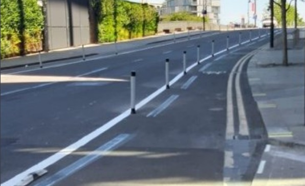
![[1]](https://www.usa-traffic-signs.com/v/vspfiles/photos/w11-1_s-2.gif)
Given the way is drawn in the direction of the photo, I've used these tags.
- highway=residential
- lanes=2 one vehicle lane for each direction
- cycleway:left=lane there is a bicycle lane available when travelling down the left side of the road, relative to the median.
- bicycle:lanes:forward=yes|designated including the bicycle lane, of the two lanes in the forward direction, the leftmost you can ride on, and the rightmost it's designated for bicycles.
- motor_vehicle:lanes:forward=yes|no including the bicycle lane, the right most lane you can't drive motor vehicles on.
- turn:lanes:forward=none|right the bicycle lane must turn right.
- cycleway:lanes:forward=no|lane the right lane is a cycleway lane, and the left lane is not.
I would like to improve the wiki documentation for this but need to ensure I've got the correct tags. Thanks.
--Aharvey (talk) 02:35, 21 September 2021 (UTC)
- cycleway:left=lane not really needed with cycleway:lanes=*? Although technically correct. Looks strange to show there's a bike lane when it's only for turning, to me.
- motor_vehicle:lanes:forward=yes|no Does the dashed white line mean it's a diverging lane, or is it enterable by motorized vehicles? Usually solid line is used?
- bicycle:lanes:forward=yes|designated
- motor_vehicle:lanes:forward=yes|yes
- cycleway:lane=advisory
- ---- Kovposch (talk) 06:12, 21 September 2021 (UTC)
Combining cycleway=lane and oneway:bicycle=no → one or two directions?
In the current revision of the page, we know that cycleway=lane means there are cycle lanes on both sides of the road. If the street has oneway=yes then the lane only applies to one side of the road. That is fine.
Now, if we have cycleway=lane + oneway=yes + oneway:bicycle=no, my understanding is that it means there are cycle lanes on both sides of the road. Or should we use cycleway:both=lane (or :left and :right keys) explicitely?
Shouldn’t we clarify this point? Bxl-forever (talk) 17:08, 28 August 2022 (UTC)
Warn users at top of page
The article should right at the top say
Stop! Don't trace that bike lane from the air photos.
Just add this tag to the highway!
If I understand this correctly. Jidanni (talk) 06:31, 20 September 2023 (UTC)
Key:cycleway restructuring
Following the deprecation of the opposite tagging, I have started to update the cycleway page and would like to use this opportunity to restructure it. Here is the current draft for the new page in which I have tried to retain all the existing information and to include more current discourses (currently still in my user namespace, but I would move it soon.). The differences are mainly as follows:
- New, clean presentation of all values in a classic value table,
- Addition of a section on deprecated or discouraged tags, where the opposite tags, but also cycleway=shared appear, that was discouraged already before,
- Addition of a section on the use of side attributes at the beginning (to encourage using side attributes when tagging cycleways) and merging all information about using side attributes there,
- Merging all information about tagging cycleway in one-way roads in a chapter about that,
- Addition to the tagging of protected bike lanes.
Feel free to comment, discuss or participate! Supaplex030 (talk) 21:18, 30 June 2024 (UTC)