JA:Tag:highway=trunk
Jump to navigation
Jump to search
 |
| 説明 |
|---|
| 高速道路ではない重要な道路。 |
| OSM Cartoでのレンダリング |

|
| グループ: 道路 |
| 適用できる要素 |
| 含まれる意味 |
| よく併用されるタグ |
| 関連項目 |
| 状態:事実上の標準 |
| ツール |
一般に highway=trunk は motorway の要件を満たさない重要度の高い道路に使います。各国の道路の分類については Highway:International equivalence を参照してください。
マッピング方法

単純な幹線道路をマッピングするには、その道路の線を描きます。幹線道路が属しているすべてのウェイを選択し、それらに highway=trunk とタグ付けします。いつもの通り、幹線道路で両方向に運転することが不可能で、一方通行のように同一方向に行くのが確実なときは oneway=yes を使います。
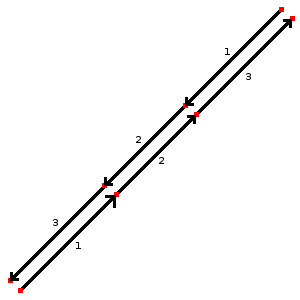
複数の車道がある場合は各方向に1つのウェイを描き、個別にそれぞれの方向をタグ付けする必要があります。図のように整列内のノードの位置を決めると、地図がレンダリングされるとき、両方のウェイがともに属していることがわかります。
幹線道路についてより多くの情報を加えるには、さらにキーを追加する必要があります。
- maxspeed=数値 許可されている最高速度を示します
- minspeed=数値 この道路で到達する必要のある最低速度を示します
- name=道路の名称
- ref=参照名 日本の例: 「6」、国の道路の識別体系を参照してください
- lanes=数値 幹線道路上に存在する車線数を示します
- motorroad=yes 道路に「自動車専用」の交通ルールがあることを示します
- destination=* 道路がどこに向かっているのかを示します。道路の方向を考慮し、 trunk_link にあるような標識に書かれた都市の名前を使します。例: 「東京」(trunk_link については JA:接続道路 を参照)
特殊な状況
通常の幹線道路でない場合はこれらの項目を参照してください:
- highway=trunk_link - 幹線道路に乗ったり下りたりするための道路(ランプ)
- bridge=yes + layer=1 - 幹線道路が通りや水路の上を通る場合
- tunnel=yes + layer=-1 - 幹線道路が通りや水路の下を通る場合
国際的な等価性
以下はタグが国ごとにどのように割り当てられているかの比較です。利用者はこのガイドで特定の国での詳細および追加のタグがどのようになっているかを確認してください。国ごとのプロジェクトは Category:JA:プロジェクトを、国固有のタグ付けガイドは JA:タグ付けを参照してください。
| 国/地域 | 幹線道路 | その他 |
|---|---|---|
| オーストラリア | National highways; state strategic road network. Connecting major population centres. For example Bruce Highway, Pacific Highway. |
Australian Roads Tagging |
| オーストリア | Autostraße |
WikiProject Austria/Schnellstraßen |
| ベルギー | Expressweg/Route express | Be:Map_Features |
| ブラジル | Rodovias nacionais (national highways, such as BR-262), vias expressas urbanas (urban expressways), 70-80 km/h | |
| ブルガリア | Скоростен път с поне две ленти във всяка посока. Ограничението на скоростта не трябва да е по-малко от стандартното (50 км/ч за населени места, 90 км/ч извън тях). | |
| 中国 | 国道(not superceded by expressways)/城市快速道路 | |
| クロアチア | Expressways (Brza cesta) and motorroads (cesta za promet motornih vozila) WikiProject Croatia/Ceste | |
| チェコ | Silnice pro motorová vozidla: |
|
| デンマーク | Motortrafikvej |
Da:Map Features |
| フィンランド | Valtatiet/National Highways | Fi:Map Features |
| フランス | Rocade, voie rapide ou voie express. Voie ayant les caractéristiques d'une autoroute. En général, une 2x2 voies avec séparation centrale. Par défaut : lanes="2", maxspeed="110" (sauf périph. Paris: 80) + ref="Nxx" ou "Dxx" + oneway="yes" + lanes="x" (si voies <> 2) |
Fr:Map Features |
| ドイツ | For Motorway Like Roads (Autobahnähnliche Straße collq. Schnellstraße) without crossings. The carriageways are separated physically or by road markings. This sign |
DE:Tag:highway=trunk |
| 香港 | Roads with route number, but not expressways or tunnels | Zh-hant:Hong Kong tagging#街道分類 Classifications of streets |
| ハンガリー | Autóút | |
| インドネシア | National Roads. Different by island. | |
| イラン | Iranian National Standardization Organization の定義による高速道路。 | |
| アイルランド | National Primary Routes, regardless of build quality. Currently numbered N1-N33. Signed in white lettering on a green background. | |
| イスラエル | National Primary Routes, regardless of build quality. They are numbered with one or two digits. Red numbers on a white background surrounded by green border. |
WikiProject Israel He:Map Features |
| イタリア | Strade a scorrimento veloci regolate da rampe di entrata/uscita e prive di incroci a raso e di rotatorie che si pongono a metà strada tra Autostrade e le Statali. Per segnalare l'esistenza di restrizioni di accesso identiche a quelle in vigore per le autostrade, usare motorroad=yes. Solitamente le Strade extraurbane principali sono di questo tipo. | |
| 日本 | 国道/National Highways | |
| 韓国 | Divided highway without ramps. Higher speeds. Few stop lights or stop signs. | |
| モロッコ | Rocade, expressway.2x2 Divided highway, every intersections with roundabout.speedlimit 80 or 100 km/h | |
| オランダ | Autoweg |
Nl:Map Features |
| ノルウェー | Nation infrastructure road (Riksvei) that are not "Motorvei" , green signs, include E-roads class A and B | |
| フィリピン | Primary national roads connecting major cities and provinces. Examples are the Pan-Philippine Highway/AH26 (not including toll expressway segments, like segments on NLEX and SLEX) that are tagged highway=motorway) , Daang Maharlika, MacArthur Highway, EDSA (includes portions not marked as part of Pan-Philippine Highway/AH26), Aguinaldo Highway, Governor's Drive, Jose P. Laurel Highway (mostly designated as Manila - Batangas Road, but short segment at Santo Tomas is designated as Santo Tomas Bypass Road) , Andaya Highway, Strong Republic Nautical Highway, etc. |
Philippines/Mapping conventions#Roads |
| ポーランド | WikiProject Poland/Klasyfikacja dróg | |
| ポルトガル | Via Rápida | |
| ルーマニア | highway=trunk is used for any national road part of a European corridor or express ways (do not exist in Romania); along with the national road shield (white on red background) E.g.: DN6/E60, DN2/E85 . |
Ro:Map Features#Drumuri |
| スロバキア | Cesta pre motorové vozidlá: |
|
| スイス | Autostrasse / autoroute de 2eme classe (semi-autoroute) | |
| タンザニア | Refers to a (paved) 'Trunk Road', as classified by Tanroads. Main roads that connect major cities in the country: e.g. T1 from Dar es Salaam - Zambia border. | |
| イギリス | primary A road (green signs) | |
| アメリカ | Surface expressway: A relatively high-speed divided road (at least 40 MPH with a barrier or median separating each direction of traffic), with a limited amount of intersections and driveways; or a major intercity highway. This includes many U.S. Highways (that do not parallel an Interstate) and some state highways. Wikipedia reference | |
| ベトナム | Trunk (Xa lộ) in Vietnam usually have more than 3 lane with lane classification signs |
例
| 画像/説明 | タグ | Mapnik |
|---|---|---|
|
|
(各車線用) highway=trunk |

|
| ||||||||||||||||||||||||||||||