Latest comment: 8 years ago6 comments2 people in discussion
I am primarily a golfer, so would like to make some general comments on what a golfer looks for in a course map. The idea is to see how these can fit in with this proposal
1. Tees - there are 2 or 3 teeboxes per hole. Here it is black for championship, white for men and red for women. The exact size and location of the box changes every few days, but there is a permanent yardage marker for each tee box. The ideal representation would be a dot or small circle around the permanent yardage marker in the appropriate colour. So the tags would be colour, hole number, distance, par and stroke index (or handicap).
2. Penalty Areas - there are red penalty areas (most commonly used) and yellow penalty areas. A penalty area may be filled with water, a swamp, scrub or trees. Natural has tags for water, swamp, scrub and trees, so these can be marked by natural=water|swamp ... with a red or yellow border as the case may be. Penalty areas are not associated with any specific hole so there will only be tags as 'penalty area', colour and natural. Until end 2018 the equivalent of penalty areas (though not exactly the same) were water hazards.
3. Rough - again may be trees, long grass, scrub or rock. For this, just the natural tag is enough (we need a natural tag for rock and long grass though). Again rough is not associated with any specific hole.
4. Bunkers - these are filled with sand or crushed shell, so we have natural=sand and a brown? border to indicate that it is a bunker. Bunkers are usually associated with holes, so hole number could be added (not essential)
5. Grass - there are 4 main types of grass in a course. By type I really mean how the grass is cut. Grass on the tee boxes, fairly closely mown. Grass on the fairways - closely mown, grass around the fairways and the greens - roughly mown, 1-3 inches deep and long grass that is in the rough and not mown at all. So ideally we need four shades of green to mark these areas. Lawgon03:40, 13 June 2008 (UTC)]Reply
The exact location of the hole varies day by day (or at least a few times each week) New holes will certainly be cut for any important tournament. On a multi day tournament, the locations will certainly be different each day. All you know is that it is somewhere on the green. So it looks like having a golf_pin is not needed.--Bduijnen 08:24, 3 August 2010 (BST)
2. The hazards comment really should be taken to heart .. it is not necessarily water .. so the tag value should not say water. Warin61 (talk) 23:59, 15 July 2018 (UTC)Reply
4. Bunkers .. I think rendering them similar to cliffs - a line pointing down in to the centre of the area would be nice, use the surface tag to render sand/mud etc. Warin61 (talk) 23:59, 15 July 2018 (UTC)Reply
5. Grass .. not always grass. There is at least one golf course that grows no grass. I refer to http://www.cooberpedygolfclub.com.au/ . Here most surfaces are sand. It is the consultancy, smoothness and resilience of the surface that I think is important here. So I'd try to get away from the grass fixation. Possibly use it as a guide? Warin61 (talk) 23:59, 15 July 2018 (UTC)Reply
Way
Latest comment: 16 years ago1 comment1 person in discussion
Ideal line to hole is highly subjective and impossible to really determine. I feel way should follow the guidelines laid down in http://www.usga.org/playing/handicaps/manual/sections/section_12.html. For this, the permanent yardage markers and pivot points should be indicated. So each way will comprise a permanent yardage marker, one or more pivot points and the centre of the green. There will be one way for each color tee. [[[User:Lawgon|Lawgon]] 06:18, 1 May 2008 (UTC)]
What about mapping the physical elements on the ground - yardage markers, tee box, green, etc. And leave the subjective elements such as ideal line up to each golfer. This will change given wind and turf conditions anyway. --Particlem19:47, 6 March 2010 (UTC)Reply
track?
Latest comment: 16 years ago8 comments6 people in discussion
I think it would be better to use the Proposed_features/Path proposal for the routes intended to be used by golf carts. This would presumably also require a new access=* value. Tracks are intended to be used by automobiles, and I don't think golf carts count as such. --Hawke18:59, 9 March 2008 (UTC)Reply
Since many of the golf courses around here and with which I have had dealings have public right of way along many of the tracks, then the correct access tags must be used! Lsces22:16, 9 March 2008 (UTC)Reply
You didn't address my point at all though. Especially since, as far as I know, most golf course tracks are *not* public rights-of-way, an extension to the access tag to indicate that they may be used by golf carts is necessary. And most of them are not usable by automobile and are paved, therefore highway=track is unsuitable; hence the suggestion of using Proposed_features/Path --Hawke21:31, 10 March 2008 (UTC)Reply
I was referring to Lsces' comment. I'd really like to get some other opinions on whether to use "track" or "path" before changing anything. --Wabba23:26, 10 March 2008 (UTC)Reply
I suggest that cart paths be tagged as golf=cartpath. As an extension to the golf tag it can easily be rendered with other items on the golf course. This is not tagging for the renderer, but is creating tags so as not to make things worse for the cartographers.
Correct tags for access and surface should be added when values depart from the defaults. I presume that the defaults will be surface=paved and access=private.
Looking at aerial photos, these look very highway=track like to me. I imagine the ground staff will use these as access points to greens, fairways for maintenance as well. In this case they would clearly be used by motorized vehicles, meeting Hawke's requirement. I'd tend to use track for any route which was occasionally used by vehicles with 4-wheels (motorized or drawn by animals). I'd avoid creating a new tag, although the combination of access permissions should allow specific rendering in these cases. Buggies are still relatively scarce on UK courses, but maintenance tracks are usually obvious, and infrastructure across water hazards is usually built to support a tractor or mower. These tracks are rarely paved on the courses I can bring to mind. SK5319:09, 17 September 2009 (UTC)Reply
I‘d tag them as highway=path+motor_vehicle=private+ (maybe) golf=cartpath. In my experience, golf cart paths are not built for motor vehicles, and don’t look anything like a highway=track generally does. Of course, maintenance tracks are entirely different from cart paths – though cart paths may be used on some courses for maintenance – so this doesn’t contradict SK53’s comment. Unfortunately, I can’t see it in the aerial photos well enough to tell whether that specific course has tracks or paths... --Hawke
Applicable to more than just golf courses
There are some places where golf carts and similar vehicles are useable outside the context of a golf course. Peachtree City, Georgia (USA) is one such community; it is a city, but there are paths in the city designed and designated for use by golf carts.
Latest comment: 18 years ago12 comments5 people in discussion
Why not use already existing leisure=golf_course? Also there are lot's of tags that should have a golf_ prefix, e.g. golf_hole -- Ulfl20:23, 9 March 2008 (UTC)Reply
leisure=golf_course is ok to specify the mere existance of a golf course at that location (as a POI). But it cannot give you the details about the different holes. Also, please tell me where you would like to add a golf_ prefix. golf=golf_hole doesn't seem reasonable to me. --Wabba21:31, 9 March 2008 (UTC)Reply
I think Ulfl may be suggesting as I do that par, dist and handicap be changed to golf_par, golf_dist, golf_handicap (ref already exists as a useful general purpose tag). That way, it is obvious, particularly to non-golfers, that these pertain to golf when encountered in the database. I am not a golfer, but I think developing specialist tagging along side general tags is a great use of OSM and I support your effort. MikeCollinson12:13, 10 March 2008 (UTC)Reply
leisure=golf_course as an area is suitable to outline the whole site of the golf course. Holes only are a part hereof. --Wabba07:32, 10 March 2008 (UTC)Reply
This reopens the discussion on the differences between node and area as have already been discussed with relation to car parks. The AREA of the golf course needs to be defined and if fine detail is then being included, then it's hierarchy becomes important, so is_in a particular course for the holes and then where there are several courses in a club, is_in that club. The main thing that I thing is missing with the proposal is the AREA of the holes. A perfect playing line is of little use to most players. They need to know if they can 'safely' pull left or right because they cant make a distance. So if bunkers get areas - so should the hole - with the tee and the green as additional areas within the hole? Lsces22:21, 9 March 2008 (UTC)Reply
My proposal includes a relation to "collect" all the holes that belong to a course. I don't see the need for an is_in tag. But I've already added an "golf=hole" area as you proposed. --Wabba07:32, 10 March 2008 (UTC)Reply
Then HOW are you proposing to collect them? How will you distinguish between hole 1 on the various courses at say St.Andrews which currently has 5 courses at the one club. The debate on hierarchy is a general one that has yet to be addressed but this is another example of the need for SOMETHING to be sorted Lsces07:47, 10 March 2008 (UTC)Reply
Is it possible to distinguish between different golf courses at one golf club? Many golf clubs have more than one course e.g: St Andrews has five: Jubilee, New, Old, Eden and Strathythynum. Also some holes have different tees but share a green/pin (the Jubilee course at Rye is one example). --PaulY19:57, 10 March 2008 (UTC)Reply
In this case just create 5 relations, each containing the respective holes. Then, just use different names: name="St. Andrews Links, Jubilee", name="St. Andrews Links, New Course", new="St. Andrews Links, Old Course" etc. --Wabba20:46, 10 March 2008 (UTC)Reply
Hazards
Latest comment: 16 years ago8 comments7 people in discussion
hazards are: bunkers, water hazards and lateral water hazards. Whether the water hazards have water in them or not is not really relevant to a golfer.Lawgon00:40, 11 March 2008 (UTC)Reply
I would render bunkers as beach. Maybe water hazards and lateral water hazards work better as ways not areas. Front and lateral are deppending on play direcction so red/yellow change along the border. They can be rendered as red/yellow dotted lines. Think of a lake, with areas it might end looking as a cake. And what about out of bounds? blue dotted lines?--Sergionaranja08:56, 13 June 2008 (UTC)Reply
with this image we can discuss what info sould be renderd or not and to point what we are talking about. move, remove, replace or whatever you want no copyright on it --Sergionaranja09:07, 13 June 2008 (UTC)Reply
I don't know that the out of bounds indication used in that book applies here, since it only has diagrams of the individual holes. On a larger map such as OSM, it makes much more sense to use some sort of linear indicator (like the dotted line in this example) for out of bounds. --Hawke22:17, 12 March 2009 (UTC)Reply
I'm torn on the merits of adding ways for hazard-lines in addition to drawing the hazard areas. Does not the hazard area itself imply the existence of a hazard boundary? If separate hazard ways are required, can we change the hazard tags to golf=hazard, golf=lateral_hazard and golf=oob for out of bounds? Rw18:47, 17 September 2009 (UTC)Reply
The (new) golf rules 2019 require tags like golf=red_penalty_area (and golf=yellow_penalty_area) instead of the old golf=lateral_water_hazard and golf=water_hazard. See randa.org or usga.org for details on the rules. Since yellow_penalty_area are used only very rarely nowadays, I suggest to substitute (or at least to suggest the update by default when in edit mode on such features) both golf=lateral_water_hazard and golf=water_hazard to golf=red_penalty_area. Then the exceptional yellow ones can be changed by hand. How can I do that?
I've been interested in this proposal for a while. I have mapped 9 holes for a course (Chilwell Manor Front 9) from Yahoo aerial imagery. Initially I thought to keep it simple and ignore all the complex cases and special features discussed here. Also I thought that golf=rough is unnecessary provided that the default colour for leisure=golf_course can be assumed to map the rough other features being rendered over this.
This simple example was generated using the following rules in Kosmos:
Colours etc. can be improved upon: my primary purpose was to demonstrate that one can get a reasonable degree of detail mapped quickly from Yahoo, and check that the tagging scheme works in practice. SK5321:57, 12 May 2009 (UTC)Reply
I have seen a few people use leisure=pitch to render greens in dark-green (e.g. at http://www.openstreetmap.org/browse/way/109211445). I think this is inappropriate, as it is a work-around, and this leads to an additional POI in many navigation device maps. The proper solution would be to customise mapnik's rendering. rudi 17:53, 10 October 2013
Tees
Latest comment: 17 years ago5 comments4 people in discussion
Tee boxes are classified as Championship, Gents and ladies (or black, white and red). Distance will vary and sometimes par and stroke index will also vary.Lawgon00:40, 11 March 2008 (UTC)Reply
Please have a look at [2]. There are more than those three colors (and meanings). So I decided to just specify the color of the tee box. I didn't come across different par and stroke indices yet, but it's a no-brainer to use "par:yellow=5" etc. in this case. Do you know a course where there are different par and stroke indices for one hole? Also, should I change "handicap" to "stroke_index"? ("Handicap" is usually used on german score cards) --Wabba11:15, 11 March 2008 (UTC)Reply
I think you should add par:yellow=5 type tagging as an option to the proposal. It's usage can be seen at [3]. In this case it's used to increase the par for ladies. --Milliams23:14, 26 March 2008 (UTC)Reply
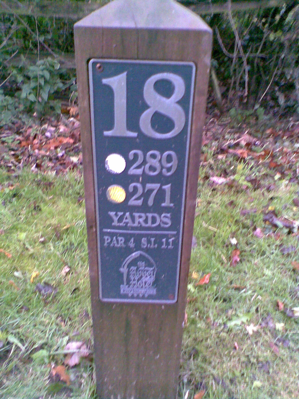
I don't know much about golf, but was staying at a hotel with attached golf course at the weekend. I took a photo of a couple of the pegs at the tees which look like this:
Media:AbbeyHotel18thTee.jpg
I don't have sufficient details I don't think to map any of the course in the way that the examples here make look so amazing, so how best should I tag at present so as this information is available to anyone who wants to build on it? EdLoach14:46, 3 November 2008 (UTC)Reply
Course and slope rating
Latest comment: 13 years ago6 comments6 people in discussion
course_rating and slope_rating are included, perhaps we should add length as well for each set of tees? Rw06:54, 15 July 2009 (UTC)Reply
As a golfer I would not look for course and slope rating on a map. Besides there are to many. A typical course can hasup 4 slope and course ratings. In theory you would need a course and slope for each combination of tee color and gender, if there are front, normal and back tees, you have many variations.
A further complicating factor is courses where there are 27-holes (3 loops of 9 holes) and where all three combinations of two loops are used and have there own course and slope rating. My advise is to simply ignore course and slope rating. --Bduijnen 08:12, 3 August 2010 (BST)
Have a look at the 2012 edition of the EGA Handicap System , p. 25, where it is said that it is recommended that tees should be rated for both men and women when applicable. --gerdami21:26, 3 January 2012 (UTC)Reply
I agree that the cr and sr should be defined per gender, almost all courses in Sweden I belive have both on all tees. so cr:<tee color>:<gender>=<number> . the front normal and back tees I do not understand, can the same tee have three different positions? When it comes to the 27-holes-question. I belive there should be a cr and sr for each 9-hole and later you use some nice formula to get the "true" cr and sr, but I also know that some clubs have made a specific rating for each 18-hole combination.. So I dont know the best solution there. --Thod01:18, 27 November 2012 (UTC)Reply
Personally, "cr" and "sr" are too short of abbreviations. Non-golfers would have no idea what those tags are without looking them up. "course_rating" and "slope_rating" do not take up much more in the database and they give the basic idea of what they are noting. --Jaggedmind (talk) 21:35, 3 April 2013 (UTC)Reply
Hole names
Latest comment: 18 years ago2 comments2 people in discussion
Golf_yardage_fake.png Example of hole of a golf course described in yardage books. Values are fake. SVG for editing available.
Distances
Latest comment: 16 years ago2 comments2 people in discussion
Should you specify (optional) units, or are golf distances always measured in yards (or is that just near here)? --EdLoach12:35, 15 April 2009 (UTC)Reply
We should reuse distance=* which already exists, instead of dist.--Cordialement, gerdami 13:06, 26 August 2012 (BST)
Golf "communities"
Latest comment: 16 years ago2 comments2 people in discussion
How should golf "communities" be represented and tagged? In Florida, we have suburban residential developments where the houses face cul-de-sacs and have their back yards opening onto golf fairways and greens, across which are the back yards of other houses facing yet other cul-de-sacs. So the course is interleaved with the residences. These tend to be in gated communities not open to the public, but nonetheless they are part of the landscape. There is one not far from where I live, and I have been reluctant to undertake all the work of mapping it. I'm not a golfer, and I would not be able to get the kind of detailed information you are proposing here, so it would have to be all from the aerial imagery. Any suggestions? I've been marking large residential areas as [landuse=residential], but that doesn't seem appropriate for this kind of development.--EdH 10:38, 2 July 2009 (EDT)
I'd expect the leisure=golf_course and landuse=residential to be interleaved with the boundary at the out-of-bounds marker for the back yards. This makes for a lot of work drawing the long convoluted boundary but reflects the reality of the community. Rw06:47, 15 July 2009 (UTC)Reply
Latest comment: 17 years ago1 comment1 person in discussion
I've seen the holes on each course ranked from 1 (hardest) to 18 (easiest) in North America. The main article has this reversed. Does this tradition vary by location? Rw06:41, 15 July 2009 (UTC)Reply
No this is the same all over the world. This so called stroke index is from hardest to easiest, and it is used to determine on which holes you receive your handicap strokes. And you need them most on the hardest holes.--Bduijnen 08:15, 3 August 2010 (BST)
Disc Golf
Latest comment: 16 years ago1 comment1 person in discussion
Can this proposal also work for disc golf courses? There is also tees and baskets (holes) and ideal ways to holes. This way if the proposal is generic enough it can be used to tag both normal golf and disc golf (others?). Then the whole course can be identified for example leisure=golf_course or leisure=disc_golf_course. --Jrutila07:19, 24 August 2009 (UTC)Reply
I agree that this proposal could be used for other 'golf' sports including both disc golf and miniature golf. It seems like the sport=* key would apply to the relation ie type=golf_course with sport=golf or sport=disc_golf or sport=miniature_golf Scottyc 23:09, 20 August 2011 (BST)
Set this up as "additional tags" proposal
Latest comment: 15 years ago2 comments2 people in discussion
There's lots of great ideas for detailed information we could be tagging. Dont know if you guys are close to reaching agreement on all of that anyway, but can I suggest we create a basic page for leisure=golf_course, and then re-frame this as an "additional tags" proposal for the continuing discussion? ....unless there is still dispute about main leisure=golf_course tag itself that is. -- Harry Wood01:38, 29 September 2009 (UTC)Reply
This proposal on additional tags is quite old already too... Any reason why it is not moving forward? -- Ij22:16, 8 March 2011 (UTC)Reply
Amenities
Latest comment: 16 years ago2 comments2 people in discussion
I'm mapping a 9-hole golf course which operates as 18 holes, where golfers tee from white tee areas for 1–9, and red tees for 10–18. No problem entering handicap:white= and handicap:red=, but how to enter ref=? Should I designate the first hole as ref=1/10? —MichaelZ. 2011-05-07 16:53 z
Oops, spoke too soon. Men and women drive from the same tees, but have different handicaps. So it's something like handicap:red:men=13, handicap:red:women=11. The only way the current scheme would work is to map the course with two sets of overlapping holes. —MichaelZ. 2011-05-07 16:59 z
Sounds like relations could be used. You'll have to invent the convention yourself, but I don't think its that difficult: basically you have to include the relevant tee and green to define hole. The rest of the tagging would be as for one mapped with ways only. Remember that the Old Course at St Andrews has holes with shared greens. SK53 18:49, 7 May 2011 (BST)
Ready for RFC?
Seems like this proposal is mature enough for RFC. Any objections to submitting it to the list? --Dahc 02:00, 24 May 2011 (BST)
golf layer prototype using ITO Map (online version is in outline only)
At ITO World we have been putting a lot of work into all sorts of specialist map rendering using ITO Map. All views are global and all data is updated daily so there should be no long delays waiting for new rendering and it will be universally vailable. Today we have released a very rough version of our new golf layer. The current view uses a blue outline for a golf course with a name, and a red one for one without a name. It shows holes, fairways, greens and bunkers in outline; from later next week it will produce a better view (see right for an example of what we are proposing) with nicely filled features. Will be very happy to go through some rapid iteration of map rendering rules after that update. Can I suggest that cart paths use 'highway=footway;service=golf;access=private' or something similar? Given the long delay to date it may be sensible to hang on until then for a vote? PeterIto 09:39, 27 May 2011 (BST)
I don't think service=golf is needed. The existing highway=footway/highway=path/highway=track tags should be sufficient. golf carts could perhaps have their own access tag like motor_vehicle and moped etc, but it isn't for any old golf carts - just ones with permission to be there (so probably access=private to club members as you suggest, be they on foot, on golf carts, or hitching a lift on the back of the mower). --EdLoach 10:55, 13 October 2011 (BST) PS: Like the layer. Have started adding more details to local courses as a result.
Why not just document Key:golf?
Latest comment: 14 years ago1 comment1 person in discussion
Has this proposal changed at all recently? I see the above suggestion that we should perhaps move to RFC, but look at
the usage statistics - this proposal is already widely accepted, it seems. --EdLoach 16:03, 6 September 2011 (BST)
+1 There are a lot of well used proposals such as this one that are 'stuck' awaiting some vote. I have been doing a lot of documentation work on the wiki recently and have tended to base the guidance on both what people are actually doing and also the range of views expressed on the talk pages (and personally I have virtually completely stopped listening to the email lists). I would fully support moving this onto the main area given that there don't seem to be any rival systems that I am aware of and there is clearly a need for something. PeterIto22:00, 3 January 2012 (UTC)Reply
+1 Who want to make the effort for submitting to vote ?User:courdi95
What about Nodes for the front/center and back of the green
For Golf course GPS programs it would be great to have these distances. Most of the apps/devices out there that are used on a golf course always show you the three distances since the hole location is normally changed on a daily basis.


