Talk:Tag:highway=busway
Foot / Bicycle
Does this tag implies foot=no + bicycle=no as well? --Nighto (talk) 10:25, 28 April 2021 (UTC)
highway=buswayimpliesaccess=no+bus=designated+emergency=yes, which further impliesfoot=noandbicycle=no. —Colgza (talk) 13:43, 28 April 2021 (UTC)
No Rendering
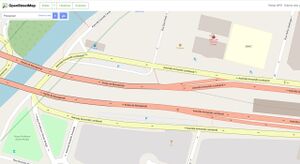
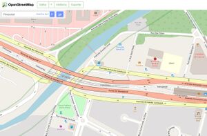
Of course there is the mantra to not tag for the renderer, but changing an already mapped BRT corridor with highway=service + access=no + bus=designated to highway=busway makes it disappear from the standard rendering, which I don't think is acceptable.
Please check the following images, the first one is in z19, the ways with highway=busway are completely transparent, while in z18 the rendering still shows the previous highway=service + access=no + bus=designated. I have reverted those changes as I don't think that's reasonable.


--Nighto (talk) 10:32, 28 April 2021 (UTC)
- There's an open issue at openstreetmap-carto to render this. https://github.com/gravitystorm/openstreetmap-carto/issues/4226 --Nighto (talk) 10:47, 28 April 2021 (UTC)
- The Carto devs are not willing to add rendering for
highway=buswayuntil it receives a wide-enough level of adoption. Removing thehighway=buswaywill decrease the likeliness that rendering will be added. I therefor think that you should re-add the tags that you removed. - —Colgza (talk) 13:39, 28 April 2021 (UTC)
- Well that' sorta of chicken-and-egg problem. I honestly don't think it's acceptable to break a number of different map regions rendering just with a hope that it gets rendered eventually, without a timeframe. --Nighto (talk) 13:55, 28 April 2021 (UTC)
- It's a problem, but the problem isn't relevant to the question of which tags should be used. Removing
highway=buswaybecause it does not render 'is' tagging for the renderer. The fact that this tag does not render is not a problem with this tagging scheme, but a problem with the renderer. —Colgza (talk) 15:00, 28 April 2021 (UTC)- I'm sorry I didn't made myself clear. The problem I see is that
highway=buswayconflicts withhighway=service, which is one of the tags currently used to (correctly) map BRT systems. Just becausehighway=buswaywas created it doesn't makehighway=service(with the other tags combination) invalid, and therefore changing all BRT systems worldwide to the new tag could even be perceived as vandalism, specially because the work of dozens of people would become invisible.--Nighto (talk) 15:10, 28 April 2021 (UTC)- I did not misunderstand you, but I'm afraid that I was unclear myself, and for that, I apologize. What I am trying to communicate is that rendering has absolutely no bearing on whether a tagging scheme is valid.
- Because
highway=buswaywas approved and made official, it is now invalid to tag busways withhighway=service. - Although changing BRT systems to the new tag en masse could be perceived as recklessness, it is not vandalism.
- —Colgza (talk) 15:40, 28 April 2021 (UTC)
- I'm sorry I didn't made myself clear. The problem I see is that
- It's a problem, but the problem isn't relevant to the question of which tags should be used. Removing
- Most Carto developers are European. In Europe,
 guided busways are much more common than
  bus rapid transit systems. In the Americas and Asia, the situation is reversed: guided busways are very rare and BRTs are quite common. The reasons for this are historical and complex. Wikipedia is probably incomplete, from these links I quickly calculated at least 830 km of BRTs and at least 68 km of guided busways in the world. I don't expect the actual numbers to be much higher than those lower boundaries. BRTs are cheaper to build and operating costs are similar, since most guided busways systems are not fully autonomous, so BRTs tend to proliferate faster. To avoid the chicken-and-egg situation, we should create an organized activity and involve the local communities. What needs to be done is not difficult, we must only ensure that local communities understand and agree with the change, as their BRTs will be temporarily blank on the map. --Fernando Trebien (talk) 15:35, 28 April 2021 (UTC)
- Well that' sorta of chicken-and-egg problem. I honestly don't think it's acceptable to break a number of different map regions rendering just with a hope that it gets rendered eventually, without a timeframe. --Nighto (talk) 13:55, 28 April 2021 (UTC)
"Remove your just-approved tag because it's not rendered yet" is a nonsense argument. There is no 'forward compatible' way to tag for the renderer. Please have some patience and if possible contribute to the upgraded tagging scheme to speed up the transition process. --501ghost (talk) 15:53, 28 April 2021 (UTC)
It appears that the rendering is not yet done, and TransJakarta busways in Jakarta are currently tagged as highway=service to make them show on the map (see https://www.openstreetmap.org/#map=19/-6.24018/106.82776). Hanif Al Husaini (talk) 16:05, 3 February 2022 (UTC)
I have just created a [PR on openstreetmap-carto to render busways as they used to be rendered with highway=service + access=no](https://github.com/gravitystorm/openstreetmap-carto/pull/4714), please check it out, I've added several images before and after the proposed change.--Nighto (talk) 15:55, 10 October 2022 (UTC)
Use for highway=busway non-BRTs
There is a (German) discussion about the use of highway=busway for physically separate buslanes (mostly on tramways with separate trackbeds but not only), none of which are BRTs. Originally, I wanted to ask some mappers in my region of editing highway=service for busses only but then others came in (outside the region) who are disagreeing with me that highway=busway is incorrect in this case.
Before we start the discussion, for my vocabulary, a "busway" a highway which serves busses only but can be theoretically driven by any vehicle (e.g. permits for emergency vehicles) which can both appear as a lane and as a separate carriageway. A BRT is a special bus system which (mostly) run on exclusive lanes which can be handled by both painted bus lanes and exclusive carriageways.
My rationale is that the description also mentions BRT at the beginning only and implicitely in How to map (rapid transit) but is otherwise kept fairly generically, used for any bus network, not just BRTs.
This is on top of the fact that the word "busway" is used for busway=* which doesn't mention BRTs at all, not even in pointing towards highway=busway when physical separations exist. Busways also have the bicycle counterpart cycleway which too has tags for lanes (cycleway=*) and separate ways (highway=cycleway) and applying the logic would mean to tag cycleways for bicycle highways but not for inner city bicycle streets nor separate bicycle lanes. It also is the flat surface counterpart to highway=bus guideway, the latter which only mentions "busway" but doesn't explicitly use BRT and redirects to highway=busway without even mentioning BRTs, calling only "normal paved roadways that are designated for buses only" instead. Conversely, the use of highway=service still carries the problem as a use for non-access roads because most of the time (bus bays and shortcuts aside), they aren't used to access anything.
On top of that, it also is increasingly used for obvious non-BRTs (in the same thread I mentioned the Netherlands where BRTs typically aren't implemented either).
In any case, the page needs more clarification and outside of that, there also is the question on whether it's better to mark BRTs by relations than by tagging certain ways as BRT infrastructure. --ManuelB701 (talk) 05:58, 14 October 2023 (UTC)
- For anyone interested, discussion is currently taking place on the community forum: https://community.openstreetmap.org/t/highway-busway-on-non-brts/110578
- Squizie3 (talk) 20:40, 18 March 2024 (UTC)
- Forgot that this exist and it's been a while since it's been changed. I thus can simply mark that topic as
- I think that the concept of a busway doesn't always imply bus exclusivity. Reading the various values of
highway=*, it's clear to me that none of the other types are exclusive in principle, but can be exclusive by default in some areas, with exceptions allowed by combination with access tags. Some busways may have sidewalks, in which case pedestrians are allowed. Some busways may share space with taxis or bicycles (similar tocycleway=share_busway), either by signage or by local law, depending on the local planning culture. But in all these cases, the defining characteristic of a busway is that it is mainly for buses, just ashighway=pedestrianis mainly for pedestrians, including pedestrian-only ways. --Fernando Trebien (talk) 21:39, 24 September 2025 (UTC)