Zh-hant:Key:shelter_type
Jump to navigation
Jump to search
 |
| 說明 |
|---|
| 本標籤進一步定義被標記為amenity=shelter的物體 |
| 組: 屬性 |
| 用於這些元素 |
| 已記載的值: 16 |
| 一併使用 |
| 狀態:已批准 |
| 此標籤的工具 |
使用shelter_type=*進一步定義元素amenity=shelter。
值
本表並非固定,如果需要的話可以透過額外的值擴展本表。本表應呈現用途型態,而非描述建築屬性。在本頁添加額外的值前,請先在意見欄進行討論。
| 值 | 描述 | 圖片 |
|---|---|---|
basic_hut
|
基礎小屋(例如山屋、工寮等)是鄉村的小型建築,提供基礎的掩蔽與過夜的處所。
如果小屋被上鎖且僅供所有者使用,考慮添加標籤 |

|
changing_rooms
|
更衣間常見於水域活動設施附近的小型建築,用途為換裝(獨木舟航線、海灘、人們游泳或沖澡的場所)。 | 
|
field_shelter
|
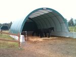
野外庇護所是鄉村供動物庇護的建築(例如:馬)。天氣惡劣時,如果野外庇護所允許使用的話,也能供人們使用。 | 
|
lean_to
|
lean-to通常是鄉村地區供露營使用、具有三道牆的亭子。 | 
|
picnic_shelter
|
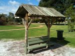
野餐場所供躲雨的設施,一般開放大眾使用。考慮也添加building=roof。
|

|
public_transport
|
鐵道、公車沿線月台或站牌的小型亭子,一般坐落於大城市。 | 
|
rock_shelter
|
言
岩壁庇護所是峭壁或斷崖底部如洞穴般的狹窄腹地。 |

|
sun_shelter
|
供遮陽的亭子。與shelter_type=weather_shelter不同,遮陽亭只能提供少量遮雨或躲避惡劣天氣的功能,因為亭子的側邊可能是開放的,屋頂也只設計作遮陽。除了shelter_type=picnic_shelter以外,其他型態都無法供野餐使用。
|

|
weather_shelter
|
山區或鄉村道路旁的小亭子,主要只供短暫休息。除了緊急情況外(例如遭遇雷陣雨),相對於shelter_type=picnic_shelter或shelter_type=lean_to,避雨亭並非供人用餐、過夜或睡覺的處所。如果無法明確透過shelter_type=*標記,暫時以shelter_type=weather_shelter兼容。
Used for small shelters in the mountains or alongside roads in the countryside. Primarily intended for short breaks only. In contrast to alpine huts or |

|
| user defined | All commonly used values according to Taginfo. |
標記
其他常用的標籤:
渲染(提議中)
- Icons for key:shelter_type, 32 × 32 px
-
Basic hut
amenity=sheltershelter_type=basic_hut -
Lean-to
amenity=sheltershelter_type=lean_to -
野餐亭
amenity=sheltershelter_type=picnic_shelter


