Ko:편집 표준과 규약
- more general recommendations and tagging recommendations에 관한 내용은 Good practice 문서를 참고하세요.
아래 내용들은 지도를 편집하는 몇몇 표준과 규약을 소개한 것입니다.
태깅(Tagging)
- Map Features - OSM에서 널리 사용되는 태그들이 소개되어 있습니다.
- Category:Tagging guidelines by country - 행정구역 경계 또는 국경을 명확하게 태깅하는 규칙을 다루고 있습니다.
- Category:Features - 태그를 목적이나 기능에 따라 분류한 내용을 다루고 있습니다.
- Category:Proposed features - 새로운 태그나 아직 잘 알려지지 않은 태그들을 찾아볼 수 있습니다.
도로
물리적인 도로, 거리, 도보, 등은 일련의 노드들이 묶여 경로(way)의 형태로 그려집니다. 이러한 경로는 반드시 highway=* 태그와 이름으로 태그되어야 합니다.
많은 도로들은 대부분의 OSM의 편집기에서 똑같이 보이만, 렌더링 되면 태그 값이 적용되어 각기 다른 색상과 굵기로 나타납니다.
도로 이름과 작명 관례들
약어를 사용하지 말 것
name 태그를 사용하여 설명하지 말 것
이름이 붙지 않은 오브젝트
이름이 없는 오브젝트 (보통 거리):
같이 보기
일방통행 도로
만약 통행 방향이 단방향(oneway)라면, 통행 방향에 맞게 길을 그리고 oneway=yes 태그를 추가하는 것은 매우 중요합니다.
분리된 도로
분리된 도로는 양방향 통행(대면 통행) 도로에서 교통 흐름이 다른 차로(車路) 사이를 물리적으로 막는 분리대를 설치한 도로입니다. 중앙분리대가 설치된 고속도로는 분리된 도로의 대표적인 예입니다. 한국에서는 보기 드문 형태지만, 지역과 접속하는 차로와 접속하지 않는 차로를 조합하여 3개 이상으로 분리된 도로도 있습니다. 이를 지역-고속 차로(Local-express lanes)라고 합니다.
분리된 도로를 그릴 때는 반드시 두 도로 사이를 분리된 채로 그려야 합니다. 각 도로는 일반적으로 일방통행(oneway=yes)이며, 도로 방향에 맞게 태그해야 합니다. 또한 떨어진 두 도로를 연결하는 도로를 그릴 때는 물리적인 장애물이 없어서 실제로 두 도로 사이를 이동할 수 있는 경로에 그려야 합니다. 그리고 분리된 도로가 서로 평행하게 배치되어 있을 경우, 두 도로의 노드를 쌍으로 이웃하게 배치합니다. (아래 그림을 참고) 이렇게 편집하면 도로, 특히 커브가 있는 길이 예쁘게 렌더링된 결과물을 볼 수 있습니다. 또한 전체적으로 도로 사이의 간격을 일정하게 만들 수 있습니다.
노드 사이의 간격은 커브를 나타내는 정밀도에 따라 결정이 됩니다. 노드 사이의 간격이 좁을 수록 정밀도가 높습니다.
 |
 |
JOSM 도구
JOSM은 편집 과정에서의 고통을 줄여주고 시간을 절약해줄 수 있는 몇 가지 도구를 제공하고 있습니다.
- Align Nodes in Line (L) 은 중간 점을 정렬하고 길을 곧게 유지하는 데 도움을 줍니다.
- Parallel way mode
- Ctrl modifier와 Extrude tool 로 오브젝트를 평행하게 이동할 수 있습니다.
- 또한 Anglesnapping mode 로 정확한 각도를 유지할 수 있고, Improve Way Accuracy 로 꼬인 길을 고칠 수 있습니다. JOSM/Plugins/CommandLine#Usage 는 정확만 모양들을 그리기 위한 더 많은 도구를 제공할 것입니다.
회전교차로
- Roundabouts 문서를 참고하십시오.
교차점
- Node#Nodes_on_Ways 문서를 같이 참조하십시오.
모든 도로의 교차점은 노드로 여러 길들을 연결하는 노드로 그려집니다. (둘 또는 그 이상의 여러 길들은 하나의 같은(!)노드를 공유합니다.)
교차 지점에서 서로 다른 도로의 두 노드를 연결시키지 않고, 단지 같은 위치 또는 거의 동일한 위치에 배치하면 안됩니다. 비록 겉보기에는 제대로 된 것 같이 보여도 지도상에서 두 도로의 경로는 끊겨있는 것으로 규정됩니다. 실제로 두 도로가 연결되어 있다면 반드시 OSM 편집기에서 도로의 두 노드를 연결하여 문제를 해결해야 합니다.
만약 편집기의 지도 스타일로 공유 노드를 식별할 수 없다면, 이럴 때 사용하는 트릭은 바로 문제의 노드를 살짝 움직여보고 길이 같이 움직이는지 지켜보는 것입니다. 꼭 되돌리기하여 테스트한 것을 움직여주세요. (뒤로 가기 버튼이 아닙니다!)
몇몇 품질보증 도구는 잠재적으로 연결되지 않은 도로 문제(어느 도로 끝이 다른 도로에 가깝지만 연결되있지 않은 경우)를 파악하는데 도움을 줄 것입니다.
-
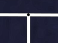 간단한 유효 도로 교차점 (가운데 있는 검은 점이 두 하얀색 도로에 포함되어 있음)
 -
 잘못 그려진 도로 교차점
 -
 교자점 및 비교차점의 예시 (설명을 확인)


다리

bridge=yes와 layer=1로 태그된 다리다리는 분리된 경로로 그려집니다. 도로가 하나의 단일 경로로 그려지는 경우가 있지만, 분리된 여러 개의 경로가 끝점끼리 연결되어 저마다 다른 태깅을 이루는 방식으로 도로를 태깅하는 경우도 많습니다. 다리가 있는 도로 또한 마찬가지입니다. 그리고 많은 편집기들은 후자의 경우를 편리하게 편집할 수 있도록 경로를 쉽게 분리하는 기능을 제공하고 있습니다.
도로와 이름 태그는 전체적으로 적용되어야 합니다. 다리로 표시되는 짧은 길은 추가적으로 bridge=yes와 layer=x로 태그되어야 하며, x는 도로 아래에 있는 지물의 레이어 태그 값보다 1 이상 커야 합니다. (또는 도로 아래에 지물이 없을 경우 1로 태그합니다).
다리가 도로의 교차점와 곧바로 연결되지 않는 경우가 있습니다. 이럴 경우 반드시 교차점과 다리를 연결하는 도로를 추가해야 합니다 (아래 사진 참고):

자세한 내용은 Key:bridge 문서를 확인해주세요.
영역 태깅
영역은 닫힌 경로입니다
태그하고 싶은 지물이 (도로, 강, 철로와 같은) 선이 아닌, 영역으로 그려지는 경우가 있습니다. For instance a wooded area, a park, or a lake are all Map features which are areas. Create a new closed way which represents the outline of the required area. Annotate this way with the required tagging from the map features page, such as natural=water (for a lake), landuse=forest (for a forest), or leisure=park (for a park), etc.
영역으로서 도로
Most ways are assumed to be areas if they are closed (i.e.--if the way connects back to itself). However, there are some exceptions to this, such as highways, which are generally assumed to be ways. If the highway is meant to be an area (for example, a pedestrian square), then an area=yes tag should also be added, to imply that this feature is not just representing the way that forms the border, but the area within it, too.
노드를 공유하는 영역과 경로
There is not clear consensus yet on how to draw areas adjacent to ways. They may be drawn either by leaving a small gap between the area and the way or by connecting them so that the area shares nodes with the way. That being said, when the way is a highway, it usually is most accurate to include a gap, so that the area ends by the side of the road and does not share nodes with the road's way. This is because highway ways usually are traced along the centerline of the road, and it is unlikely that the area being tagged actually extends to the center of the road.
Accuracy
- See main article: Accuracy
Accuracy is important during mapping. Beware of systematic errors of aerial imagery (see for example Bing#Precision). Remember, that when tracing roads — particularly winding, rural ones — you should add enough points to make each curve look like a curve. Of course, this is entirely subjective, as curves made entirely of lines will only ever approximate a "true" curve (which has an infinite number of nodes), and will always look like a series of lines when zoomed in past a certain point no matter how many nodes there are.
To generalize, though, sharp curves (those having a small radius) require many, closely-spaced nodes, while broad, long-radius curves can consist of fewer nodes having more distance between them. Without a hard-and-fast rule, it is best said to simply use good judgement and strive to seek a balance.
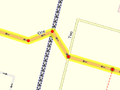
Small example using GPS traces
Below there is an example of a very roughly-traced rural 2-kilometer road. It's rather crude, particularly on the sharp curves. We would normally expect mappers to represent this kind of road with more nodes than that.

This is the same 2-kilometer road - but this will look much better on the map, and gives the map user a better sense of the curves of the road. You can see the road on the map. You can see, that ... other mapping services] have a similar degree of accuracy.

Note: Keep in mind that the road in the diagram below is about 2 km long. For very short roads you do not need to add that many nodes. If a road is perfectly straight then a node at either end is always sufficient, regardless of how long it is.
It's easy enough to "fix" these things i.e. enhance the detail of the road. Normally you should just add more nodes to the existing way. If you choose to delete and redraw a whole road, check that the nodes don't themselves have tags e.g. a highway=crossing node. Potlatch and JOSM] will highlight tagged nodes.
Date and time
Simple definition
Dates should be in ISO 8601 format, i.e. YYYY-MM-DD.
Precise tagging
- Key:opening_hours#Examples or more complex and precise Key:opening hours/specification
- Category:Time data standards contain overview of all tags involved in specifying time
Miscellaneous
- Intersections and interchanges - These are most likely to be always improved by someone else, no matter how much detail you put in
- The initial level of detail should include correct connections from/to each road and link road and the existence of any bridges and underpasses; remember to set oneway tags where applicable.
- For intersections any pedestrian crossings are valuable information; add a node in the way they cross at their location
- After that there's still lots of detail that can be added (as with all roads: number of lanes, speed limits,
lit=yes/no
- Accuracy. How do you judge and or indicate the accuracy? How accurate is good enough? Is a rough approximation better than nothing (i.e. inaccurate roads get refined the way wikipedia articles do).
- A GPS trace is almost always more accurate than other sources available to us. Still several, even tens of traces can be used to improve the accuracy. Do note though:
- Sometimes and in some environments the GPS trace can wander off to some direction (often 15-30 meters but even 90 meters); compare the trace with your memory, photos and notes to see if straight roads appear as a reasonably straight set of trace points.
- If it's a new road (nothing previously entered in the area) and there aren't any aerial images available, draw it in anyway
- If there are already other roads around and your trace seems bad, try to deduce the "real" form from the trace by not crossing roads that don't intersect with the road you traced.
- How accurate is good enough varies with each user:
- For most uses it's accurate enough when it's not misleading: say when a cycleway drawn on the map
- shows all correct bends and intersections
- and no nonexistent ones
- and is on the right side of the nearby road / stream / railway
- and is roughly the correct distance away from those features (some editors have support for measuring distances)
- Some may later want to draw fences, hedges and walls around the houses (where they exist); they will have mapped their locations to within a few meters by repeated traces and considerable amount of deducing and aligning things in lines
- For most uses it's accurate enough when it's not misleading: say when a cycleway drawn on the map
- Not only inaccurate roads, but those lacking secondary information, are refined later anyway. When contemplating on whether to approximate some road, try to consider if a user would find any value in the approximated form - is it likely to be within, say, 50 meters from the real location at all times (in otherwise unmapped territory)? If you approximate, do add a
source=approximationor similar tag to the way.
- A GPS trace is almost always more accurate than other sources available to us. Still several, even tens of traces can be used to improve the accuracy. Do note though:
- Is it constructive/helpful to mark a road that you know is roughly in the right place but don't have any supporting GPS data?
- This depends again on what else is there:
- If an urban road is missing in a rectangular grid and you confirmed its existence and it was, say, roughly halfway between the parallel roads: the position is likely to be almost as good as the position of those parallel streets when you draw it in.
- If the missing road ventures into the unmapped territory winding along the way, it's likely better to draw just a stub for the starting point and add a
FIXME=continueon the last node. If one were to draw the full way freehand, it would very likely be too short/stretched/skewed - unless there are good aerial images available.
- This depends again on what else is there:
- Landmarks, footpaths, etc.?
- How do you indicate that one road passes over or under another? - See the description for bridges above, and Key:bridge.
- If a road is made up of several/many ways, all ways should carry the name and/or ref tags.
Topology
- Is correct topology more or less important than accurate location?
- In the end both are equally important and not even mutually exclusive, but since with our tools the topology can be surveyed more accurately than the location, it should be always kept correct, even if that leads to some nodes being some meters more off than otherwise.
- If a road is a dual carriageway it should be shown as two lines
- If a road has a small traffic island (eg at the approach to a large roundabout) should this be represented as a triangle or not? How big should it be before it should be drawn?
경고: 오픈스트리트맵은 중독성이 강합니다. 자주 휴식을 취하세요, 할 일이 많으니까요.