Mappa Mercia/Past Activities
For forthcoming meets see the Mappa Mercia page
OpenStreetMap's 10th Anniversary
Mappa Mercia hosted an event in Birmingham between 12noon-2pm (Saturday 9th August 2014), at Six Eight Kafé on Temple Row (map). We had cake and there was of course be lots on offer from the Café. We were delighted to be joined by a few new faces.
2016
| Date | Location | Notes |
|---|---|---|
| 30th December 2015 | Abbots Bromley, Staffordshire | Joint social with Nottingham group. |
| 6th January 2016 | Birmingham | |
| 3rd February 2016 | Birmingham | |
| 2nd March 2016 | Birmingham | |
| 6th April 2016 | Stratford-upon-Avon | First meeting outside Birmingham. |
| 5th May 2016 | Atherstone | Moved to Thursday due to availability |
| TBCth June 2016 | Kidderminster | Saturday mapping party |
| 6th July 2016 | Tamworth | The Globe Inn |
| TBC August 2016 | Pershore | 10th anniversary of mappamercia so we’re going to map as much of WR10 as possible |
| 2nd September 2016 | ?, Herefordshire | |
| 5th October 2016 | Birmingham | Sunset is at 18:35 so likely to be back in Birmingham. |
| 3rd November 2016 | Coventry | |
| 1st December 2016 | Birmingham |
2015
As with recent years we spent summer on tour and winter in the centre of Birmingham:
| Date | Location | Notes |
|---|---|---|
| 3rd January 2015 | Hanbury, Staffordshire | Joint social with Nottingham group. |
| 8th January 2015 | Birmingham | Normal meeting delayed by a week due to new years day. |
| 5th February 2015 | Birmingham | |
| 5th March 2015 | Birmingham | |
| 2nd April 2015 | Handsworth | First meeting outside Birmingham. Sunsets at 19:43 |
| 7th May 2015 | Bromsgrove | |
| 4th June 2015 | Water Orton | |
| 4th July 2015 | Telford | Saturday mapping party |
| 5th August 2015 | Rugby, Warwickshire | We switched to Wednesdays as this was a better day for most people |
| 2nd September 2015 | Tamworth | |
| 7th October 2015 | Birmingham | Sunset is at 18:31 so likely to be back in Birmingham. |
| 4th November 2015 | Birmingham | |
| 2nd December 2015 | Birmingham |
Summer 2014
- April 3rd, Birmingham (last meeting in our Winter home)
- May 1st, Stourbridge (High Street - The Edward Rutland)
- May 31st, Tysoe Parish Council mapping event (Saturday)
- June 5th, Redditch
- July 3rd, Walsall (The Imperial - mapping till 8pm)
- July 31st, Shenstone (The Railway Inn, Main Street)
- August 9th, Six Eight Kafé, Birmingahm (OpenStreetMap 10 year birthday party, 12-2pm)
- August 28th, Coventry (The Aardvark, on the Butts)
- October 2nd, A joint social with Beacon Roads Cycling Club at Rednall Social Club. Blackadder will be doing a talk on OSM and cycling related aspects of our mapping.
Summer 2012
- May 3rd - Monthly Meeting - White Lion, Hampton in Arden.
- June 7th - Monthly Meeting - The Litten Tree, Coventry.
- June 23rd - Mini Mapping Party - National Arboretum Memorial, Alrewas.
- July 5th - Monthly Meeting - The Bowling Green, Lichfield.
- August 2nd - Monthly Meeting, The Green Man, Coleshill.
- December 1st - Monthly Meeting & Christmas Party, The Patrick Kavanagh.
Undocumented Meetings
- West Bromwich mapping party 4/5 April?
- Regular pub meetings
- West Birmingham Mapping Party to start the challenge of completing Birmingham before Christmas 2008.
Talk about OpenStreetMap
Andy Robinson will be giving his famous talk about OpenStreetMap at a Coventry Linux Users Group meeting.
The talk, on Tuesday 1st March 2011, begins at about 8pm, though people arrive from before 7pm for a drink and meal. However, there is no obligation to even have a drink.
The venue is The Castle pub, Little Park Street, Coventry (near the Council House, it used to be the 'varsity' pub). To get to the meeting room; once in pub, turn right, up a few steps, turn right again, ahead, then left and straight ahead.
The Coventry Linux Users Group website.
2011
Birmingham City Council
Text of an email sent October 2011 to cabinet members, senior councillors and departments of Birmingham City Council
Change register for the region
| Development | Area | Start | Completion | Comments | Map Status |
| Birmingham Library | City | 2013 | construction | ||
| New Street Station | City | 2015 | |||
| Birmingham Wholesale Markets | City | 2012 | new site not yet identified; but closure of existing site confirmed | ||
| Aston University student residences | City | 2011 | construction | ||
| University of Birmingham new sports complex | Edgbaston | announced Aug 2011 | |||
| new Bournville College | Longbridge | Sep-11 | Brianboru 17:24, 25 August 2011 (BST) I'll survey this Friday 26 Aug - major upgrade to road junction still under construction and needs a survey when complete | completed as a college with estimated building outline. Needs accurate survey | |
| Longbridge Town Centre new retail development | Longbridge | 2011 | 2013? | earthworks stage as at Aug 2011 | construction with name label |
| old Bournville College | fate of site?Already under demolition thought to be housing development | ||||
| Dental hospital move to BBC Pebble Mill | Edgbaston | brownfield- labelled as new site for Dental Hospital | |||
| Selly Oak hospital | Selly Oak | fate of site when all facilities decanted to QEMC | |||
| BHX Airport runway extension | Solihull | 2012 | 2014 | major re-alignment of A45 | |
| NEC Casino complex | Solihull | development site named (only visible in editors) | |||
| Old East Birmingham College site | Kitts Green | 2011 | housing development | partly surveyed and mapped with dwellings and addresses, remainder construction | |
| Birmingham Enterprise Zone | City | The Birmingham Enterprise Zone comprises seven clusters of sites over 68 hectares - expect lots of development | |||
| Golden Square Jewellery Quarter | Hockley | ||||
| Birmingham Eastside Park | City | 2011 | New park being created near Millennium Point. Albert Street and some other roads now permanently closed. Initial edits made by blackadder. Suggest resurvey in Spring 2012 | ||
| Birmingham City University Eastside | City | 2011 | New Birmingham City University Media, Art and Design faculty under construction to the east of Millennium Point. Initial edits made by blackadder. Suggest resurvey in Spring 2012 | ||
| NVC Factory | Rubery | ||||
| Birmingham City Centre bus stop re-organisation | City | 2011 | see www.centro.org.uk/connectedcity - lots of traffic re-orgs | ||
| Metro extension Corporation Street | City | 2013 | |||
| Tesco supermarket Swan Centre | Yardley | 2011 | construction | ||
| Tesco supermarket Moseley | Moseley | ||||
| Tesco supermarket Hazelwell Lane | Stirchley | Planning Application Apr 2011 | |||
| Retirement Village Spring Rd Acocks Green | Acocks Green | brownfield | |||
| [ http://www.openstreetmap.org/?lat=52.47682&lon=-1.78651&zoom=17&layers=M Meadway redevelopment] | Meadway | 2010 | tower blocks already demolished | brownfield | |
| Selly Oak New Road | Selly Oak | Surveyed and edited Brianboru 17:24, 25 August 2011 (BST) | |||
| old Rover site housing development | Longbridge | Jun-11 | construction | ||
| Sainsburys redevelopment Selly Oak bypass | Selly Oak | ||||
| Birmingham Conservatoire move to Broad Street | City | ||||
| Aston Science Park Digital Plaza | City | see announcement[1] | |||
| New Square Church St | City Centre | Nov 2011 | see http://www.colmorebusinessdistrict.com/index.aspx?id=63 - currently under construction | ||
| i54 Enterprise Zone (Wobaston Road) | Wolverhampton | 2011 onwards (Some units opening in 2012) | see http://www.i54online.com/masterplan.html. Jaguar Landrover engine plant proposed. Groundworks to prepare the site started in 2012 | Some surveying done by blackadder 2011. |
Former Mapping Focus
- Mappa Mercia/Black Country
- Mappa_Mercia/Birmingham
- We're the pilot region for the UK in the import of NaPTAN data for bus stops. The import was completed in April for Birmingham and has also been extended to West Bromwich and Wolverhampton. Log any instances of errors that you find when surveying here NaPTAN Error Log
- Birmingham Centre Aerial Imagery Mappa Mercia/Aerial Imagery
- Mappa Mercia/Inner Ringroad
- Discrepancies between OS Locator and OpenStreetMap (as shown on [1]) can be logged on Mappa Mercia/OS Locator Bugs.
Mini projects
| Mini-Project | Notes and contributors | |
|---|---|---|
| 1 | Powerlines | And substations too! |
| 3 | Canals | We've got more canals than Venice. Let's make sure our map is accurate with all the locks, footpaths, cycling restrictions and other POIs. British Waterways have indicated that all their data is OS-derived so we're on our own here |
| 4 | University Campuses | Aston Uni COMPLETE Birmingham 90% COMPLETE City 80% COMPLETE (multi campuses)Warwick COMPLETE Wolverhampton 10% COMPLETE Coventry ?? |
| 5 | Major Buildings | Largely done in the City Centre thanks to aerial imagery. Lots of industrial buildings done. Schools and churches to complete. Labelling of buildings with names and heritage status (e.g is it a Listed Building?) |
| 6 | Footpaths | Loads left to do almost everywhere |
| 7 | Bus routes and bustops | Pilot Project to import the NaPTAN database of bus stops - will probaly be available in April. The preferred standard tagging was agreed at our March meeting as route_ref=12;34;56;78 and asset_ref=12345 and the position is definitely at the side of ther road. Some cleanup needed here. --Brianboru 15:08, 6 April 2009 (UTC) - I've added a NaPTAN Error Log to list all the errors we find in the NaPTAN data. For bus routes there's a fabulous site at [2] which renders bus route relations at zoom level 14 on a daily basis. There's a proposal for a naming convention with a list of operator codes at the Bus Routes in West Midlands page. There's a list of all bus routes and operators at http://en.wikipedia.org/wiki/List_of_bus_routes_in_the_West_Midlands_county. This is a highly dynamic set of data with bus routes and stop locations changing regularly, so it's a task that will never finish! |
| 8 | Turn Restrictions | Most are probably not entered as relations. We can't route through Brum without them. There's a neat tool for verifying turn restrictions at http://osm.virtuelle-loipe.de/restrictions/ which will then render nice German traffic signs(now it renders UK signs!) on the map. Brian - I've made a start in SE Birmingham |
| 9 | Bromsgrove | |
| 10 | Redditch | |
| 11 | Winter Maintenance - Road Gritting & Grit Bins | Adding gritting routes and grit bin data from local authorities in the region. Birmingham, Walsall and Solihull complete: current focus is Wolverhampton - see below. Data for Sandwell and Dudley is not currently available |
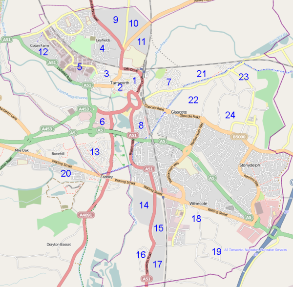
Tamworth Mapping Party May 2011
- The next micro map & social of the Midlands OSM User Group will be on Thursday, 5th May, 2011 in Tamworth. Mapping till around 8pm or a tad later (sunset is at 20:38BST) and then meet for food and drink at the Silk Kite, 59-60 Church Street, Tamworth, Staffordshire, B79 7DF. Please come and map - add your name to the table below (leave a note in the table if its your first time and you need help with mapping).
| Tamworth Cake No. | Taken By | Comments |
| 1 | miked29 | Roads mostly good. Plenty of other data could be added. |
| 2 | Paul The Archivist | MaryEliz did POIs mainly during Sept 10 event. some smaller roads still to name. |
| 3 | N/A | Completed by brianboru Sept 10 |
| 4 | Appears to have been traced. Many smaller roads need names. | |
| 5 | N/A | Roads look complete |
| 6 | N/A | Roads look complete |
| 7 | N/A | Miked29 completed with Ian Sept 10 |
| 8 | N/A | Looks complete |
| 9 | iain1940 | Needs Mapping (roads traced (Iain)) |
| 10 | iain1940 | Needs Mapping - (roads traced (Iain)) |
| 11 | iain1940 | Needs Mapping- (roads traced (Iain)) |
| 12 | Blackadder | Some roads mapped. Many more to do. Some also on south side of A51 |
| 13 | Most roads mapped but needs new survey to get more names | |
| 14 | SK53 | Mainly done S of Watling Street, although not all cul de sacs surveyed enough was seen to complete from Bing aerials. Area now complete with address interpolation ways. Dosthill Park LNR & Dosthill Hall need more detail. SK53 10:43, 6 May 2011 (BST) |
| 15 | Needs Mapping | |
| 16 | Needs Mapping | |
| 17 | Needs Mapping | |
| 18 | Needs Mapping | |
| 19 | Needs Mapping | |
| 20 | Blackadder | Roads present but need naming |
| 21 | Needs Mapping | |
| 22 | Needs Mapping | |
| 23 | Needs Mapping | |
| 24 | Needs Mapping |
Monthly Social Event July 2010
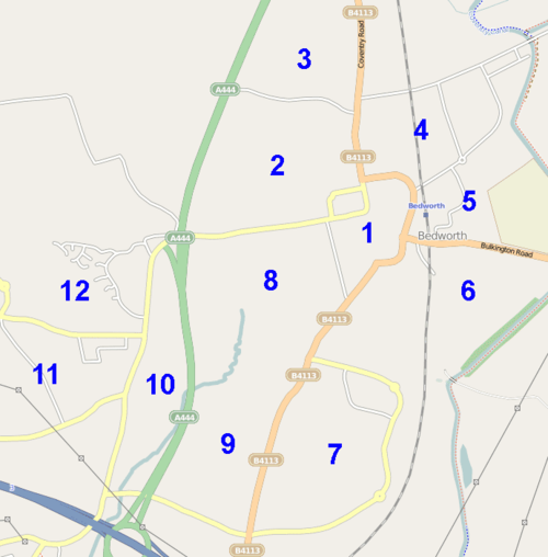
- The next social Midlands OSM User Group gathering will be from on Thursday, July 1, 2010 (2010-07-01T19:00:00) in Bedworth to the north of Coventry. Mapping first till around 8:00pm and then in a local pub.
| Bedworth Cake July 1st 2010 | Taken By | Comments |
| 1 | MaryEliz | |
| 2 | Miked29 | |
| 3 | Miked29 | |
| 4 | sherbourne | |
| 5 | sherbourne | |
| 6 | ||
| 7 | brianboru | |
| 8 | Blackadder | |
| 9 | ||
| 10 | ||
| 11 | ||
| 12 |
SatMap 12th June 2010
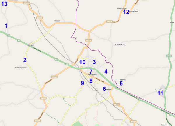
On Saturday 12 June in Atherstone and the surrounding villages.
Trains from Birmingham via Tamworth or Nuneaton, about two an hour.
We met at 10am at the cafe in the Co-op Superstore in Station Street, by the railway station. Lunch at the Red Lion Hotel on Long Street around 12:30 to 1pm. Hotel has free wi-fi.
Who went
MaryEliz
Cake
| Atherstone Cake June 12th 2010 | Taken By | Comments |
| 1 | This is Dordon | |
| 2 | Blackadder | Baddesley Ensor and Grendon Common. Mapped and edited |
| 3 | sherbourne | |
| 4 | sherbourne | |
| 5 | ||
| 6 | Blackadder | Mapped and edited |
| 7 | MaryEliz | POIs in town centre. Mapped and edited |
| 8 | Blackadder | Mapped and edited |
| 9 | Blackadder | Mapped and edited |
| 10 | sherbourne | |
| 11 | ||
| 12 | Blackadder | Mapped and edited |
| 13 | This is the south part of Polesworth or north part of Dordon |
Monthly Social Event June 2010
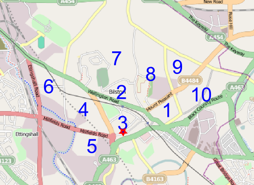
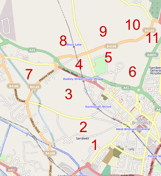
- The next social Midlands OSM User Group gathering will be from 7pm Thursday, June 3, 2010 (2010-06-03T19:00:00) at The Sir Henry Newbolt in Bilston (marked with a star on the cake below). If we meet at 7pm latest briefly to assign slices (or you can choose beforehand and just start mapping) and then meet again at 8:15pm (earlier if the weather is foul). Sir Henry Newbolt was a minor poet born in Bilston, famous for "Drake's Drum" - which seems to have been written in pirate-speak - and Vitaï Lampada a jingoist poem written in the First World War famous for its line "Play up! Play up! And play the game!" For more details see http://en.wikipedia.org/wiki/Henry_Newbolt
| Bilston Cake June 3rd 2010 | Taken By | Comments |
| 1 | MaryEliz | |
| 2 | ||
| 3 | ||
| 4 | ||
| 5 | sherbourne | |
| 6 | Blackadder | Completed |
| 7 | ||
| 8 | ||
| 9 | Miked29 | |
| 10 | miked29 |
May 22nd OpenStreetMap workshop
A workshop to develop understanding and practical collaboration between web developers and mappers. How to use OpenStreetMap and how to develop the map. A chance to explore current opportunities arising from open data initiatives: Ordnance Survey mapping and datasets from local and central government.
Programme Basics Better mapping. Using and adding photos. Adding a map to your website or blog
Advanced maps Creating custom map styles Hosting your own OSM installation
Beyond maps: Accessing the data Examples from OpenlyLocal and uk-postcodes
Mobile Maps OpenSatNav & augmented reality maps on mobile phones
Numbers up to 20 people at a time
Method a. short presentations, worked examples, how-to demonstrations b. build stuff
Tickets All gone!. (Book at [Mapitude http://mapitude.eventbrite.com/])
Monthly Social Event May 2010
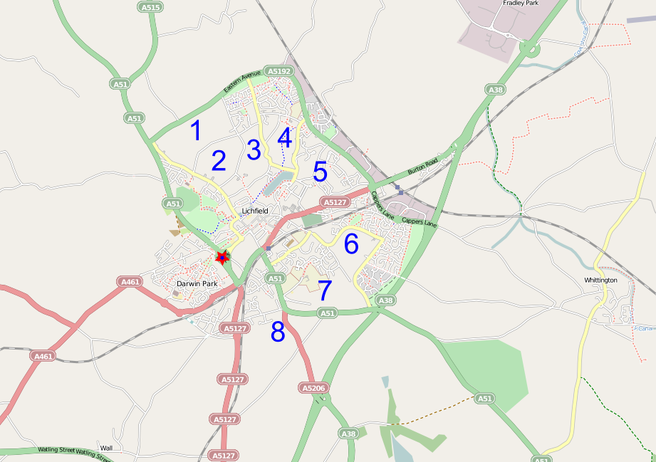
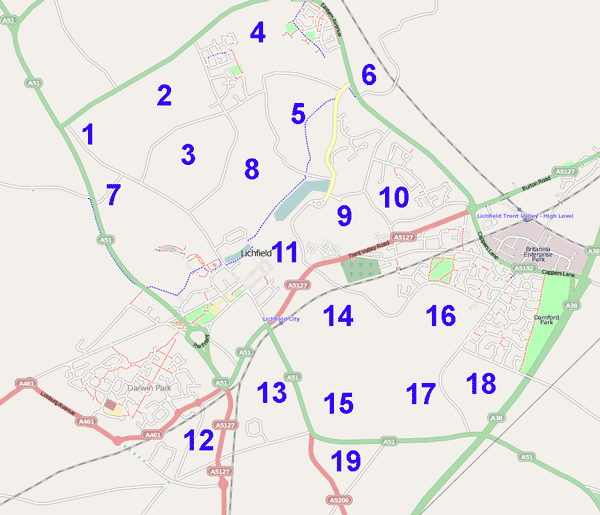
On General Election night we attempted to complete Lichfield which we almost achieved, despite the cold.
- The previous social Midlands OSM User Group gathering was from 7pm Thursday, May 6, 2010 (2010-05-06T19:00:00) at The Bowling Green in Lichfield (marked with a star on the cake below). We chose Lichfield because there's not too much left and we could complete it in an evening and the local council is very advanced with publishing Open Data so it would be great to have it completed!
Sign up to your cake slice here
| Lichfield Completion Cake May 6th 2010 | Taken By | Comments |
| 1 | sherbourne | Edits completed |
| 2 | blackadder | Edits completed |
| 3 | Brianboru | blackadder did a little bit of this area too, likley to be overlap with Brianboru |
| 4 | Brianboru | Only a couple of roads here |
| 5 | Brianboru | Only a couple of roads here |
| 6 | Mary | More roads to be mapped, will try and do before end of May |
| 7 | Xoff | |
| 8 | Brianboru | Only a couple of roads here |
April Mapping Event 2010
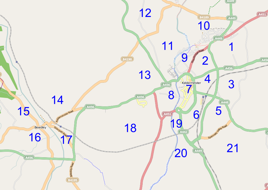
- There was a SatMap (Saturday mapping party), Kidderminster & Bewdley area (map) on Saturday 17th April. (2010-04-17T10:00:00+01:00)
- Who went?:
- Blackadder
Moreati- sherbourne
movyk- strider792
- Xoff
Pigsonthewing (maybe)- brianboru
- MaryEM
- Ciarán
- Srbrook
- Andrew
- Who went?:
The Cake
| Slice | Taken by |
|---|---|
| 1 | |
| 2 | |
| 3 | |
| 4 | |
| 5 | |
| 6 | |
| 7 | |
| 8 | |
| 9 | |
| 10 |
Gavin (aka strider792) Though on Saturday I'd like to go with someone to see how they map |
| 11 | |
| 12 | |
| 13 | Blackadder |
| 14 | Blackadder |
| 15 | |
| 16 | |
| 17 | |
| 18 | |
| 19 | |
| 20 | |
| 21 |
Surveyed on day by Srbrook. Some roads still to do. |
Monthly Social September 2009
- The gathering was a social evening on September 3rd 2009 in West Bromwich which still has some blank spots. The venue was the Wheatsheaf [3]. Mapping from 7pm onwards and then we can meet in the pub from 8pm. Please note that food is only served till 8pm! So, if you want food be back early or order before you go out mapping.
This is the cake:
For more info contact Xoff
Monthly Social August 2009
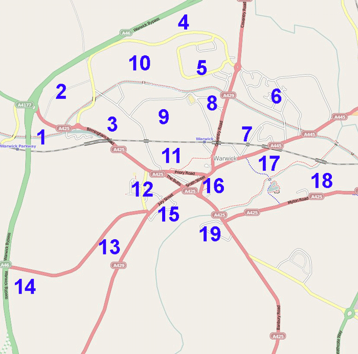
The gathering was a social evening on August 6th 2009 and will be in Warwick which is in sore need of mapping attention Venue is the Roebuck Smith Street [4]. Mapping from 7pm onwards and then we can meet in the pub from 8pm. Food is served until 9pm and main courses range from £7-£10.
This was the cake:
For more info contact Brianboru
Monthly Social July 2009
The gathering was a social evening on July 2nd 2009 in Lichfield. Meet at 7pm at The Bowling Green pub, Friary Rd roundabout Map. We will do some mapping from 7 till 8pm+ before heading back to the pub. Its an Ember Inn with food served till 9pm.
This was the cake:
For more info contact Blackadder
2008
Completing Birmingham
The MUGers in Birmingham set themselves the challenge to complete the city and its wider regions inside the M5/M6/M42 before Christmas 2008. They completed it a few days earlier, and the results are now on OSM. To celebrate this a party render (no longer online) was done of the entire City over the 2 years. There is also a printed map of the completed city available to purchase (limited edition run of 50).
South Birmingham Mapping Party
- April 12/13 2008 - South Birmingham Mapping Party.
Potlatch/JOSM Workshop
March 19th, 2008 - 19:30 for 20:00 start - RichardF and Blackadder holding a one hour, hands-on, editing tutorial using Potlatch and JOSM in Sutton Coldfield. Followed up with a pint at The Duke Inn. If you have a laptop, bring it along.
Contact Blackadder by email at blackadderajr at gmail dot com for details if you would like to come along, and add your name below.
- Blackadder
- RichardF
- Christopher
- elvin
- BigRon
- Moreati
- brianboru
- Higgy
- 80n
- SteveC
Meet # 5
21st November 2007
- OSMMUG meet at Blackadder's house
- Attendees: 6(?)
Meet # 4
- What: Halloween Social Evening.
- When: Wednesday 31st October 2007. 7:00pm
- Where: Briar Rose - JDWetherspoon's pub, Bennetts Hill, Birmingham city centre. lat="52.4798885" lon="-1.9000726". Map
- Who was there:: Blackadder, Higgy, Richard
Meet # 3
A Low key meet on 7th Feb, 2007, at The Sutton Park, Boldmere Road, Sutton Coldfield, West Midlands, B73 5UY. Lat/Lon 52.550,-1.841. Followed by food at The Kababish restaurant . Who was there, Blackadder & Richard
Meet # 2
- When: With the OSM Christmas Meetup in Birmingham on Saturday 16th December 2006 - 1pm onwards.
- Where: Suggested venue is the Prince of Wales pub, 84, Cambridge St, Birmingham, B1 2NP. Lat/Lon: 52.47975, -1.91305
Meet # 1
16 August 2006
- 7:00 till 8:30 The Griffin Inn, Church End, Shustoke, Nr Coleshill, B46 2LB, map
- 8:30 till closing time The Plough Inn, Shustoke, Nr Coleshill, B46 2LB, map
- Attendees: 9
- Comments: The first OSMMUG meet went off very well with 9 attending and some interesting discussion. The Griffin Inn turned out not to do food so we decamped to the Plough a mile down the road in Shustoke village. Discussions focused on the user interface (the online viewer and applet), Editing and tagging in JOSM, the suggestion to hold a weekend mapping party to do Rutland, also perhaps an alternative mapping event with a differnt twist to encourage different groups to get involved, builing homebrew gps units, map scanning and ....(what else?)
