Proposal:Tag:waterway=tidal channel
| The Feature Page for the approved proposal Proposed_features/Tag:waterway=tidal_channel is located at Tag:waterway=tidal_channel |
| Proposed_features/Tag:waterway=tidal_channel | |
|---|---|
| Proposal status: | Approved (active) |
| Proposed by: | jeisenbe |
| Tagging: | waterway=tidal_channel |
| Applies to: | way |
| Definition: | A natural intertidal waterway in mangroves, salt marshes and tidal flats with water flow in the direction of the tide |
| Statistics: |
|
| Draft started: | 2019-06-03 |
| RFC start: | 2019-06-06 |
| Vote start: | 2019-06-08 |
| Vote end: | 2019-06-22 |
Proposal
Use waterway=tidal_channel for a natural tidal waterway within the coastal marine environment with bi-directional flow of salty water which depends on the tides. Such channels form along protected coasts with limited wave action and a gradual slope, usually within tidal mud flats, salt marshes or mangroves. These channels can be distinguished from rivers due to the higher salinity levels and because the flow of water away from the sea at high tide is equal to the flow of water towards the sea at low tide.
These features are also know as a "(tidal) creek", "pill", "slough", or "tidal inlet". In German and Catalan they are known as a "Priel".
Rationale
Tidal channels are frequently found along coastlines with a gentle slope where the salt marsh, mangroves or tidal flats are protected from wave action. In these areas, many branching channels may be found, which can appear to create networks similar to rivers and streams. However, these are not rivers: they usually contain salt water which flows away from the sea at high tide and towards the sea at low tide.
Some tidal channels connect to an estuary of a river and may be less salty than the sea, since the connect to the estuary. But in contrast to a river estuary, in a tidal channel the water flowing towards the sea at low tide is often slightly higher in salinity than the open sea water, due to evaporation, especially in mangroves and subtropical salt marshes. Unlike in a river estuary, the flow of water towards the sea at low tide is not significantly greater than the flow away from the sea at high tide in a tidal channel. By following the channel away from the sea, or observing the flow of water at low tide and high tide, it is apparent if the waterway is the estuary of a river, or a tidal channel.
A new tag is needed so that applications can assist boaters with routing, and to provide a way to correctly tag the thousands of tidal channels that are currently mistagged as waterway=river, waterway=stream, natural=bay, or natural=water areas (the latter is normally only used for inland lakes and rivers).
While the most common British English term is "(tidal) creek", this could be confused with other common definitions of "creek" - for example the estuary of River Lea is known as Bow Creek where it empties into the estuary of the Thames, but this should be mapped as a waterway=river. Therefore the more generic term "tidal channel" is used.
Tagging
- To map a tidal channel, make a simple linear way
 and add the waterway=tidal_channel tag to it. The direction of the way should follow the direction of water flow at low tide, towards the sea.
- The centerline of a tidal channel should be outside of the coastline, because this is a marine water body located outside of the high tide line.
- In mangroves, the coastline is often drawn at the border of the open water at the ends of the tidal channel, but sometimes is drawn farther inland. In either case, the end of the mangroves should be drawn up to the edge of the open water in the tidal channel.
- In salt marshes and tidal mud flats, the borders of the tidal channel will still be outside of the coastline, but may be drawn as the outer limit of the natural=wetland.
- In tidal flats, tidal channels may only be visible at low tide and the smaller channels may change position frequently, therefore it is only recommended to map named or navigable tidal channels in mud flats.

Applies to
- Lines (way)
Additional tags:
- name=* to specify the name of the tidal channel, for example 'Big Creek'.
- width=* to indicate the width of the channel. This is an approximate average width of the channel throughout most of the length of that part of the waterway.
- salt=yes/no to indicate if the water is salty
- intermittent=yes to indicate the waterway is dry at low tide
Examples
1) Tidal channels in tidal mud flats, Germany

- name = Kronenloch
- waterway=tidal_channel
- name = Wöhrdener Loch
- waterway=tidal_channel
- The edges of the tidal channel are mapped as the end of the wetland=tidalflat
2) Tidal channel in mud flats, Scotland

- OSM Way 694300595
- name = Barbara Channel
- waterway=tidal_channel
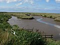
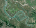
3) Tidal creek in salt marshes, England:
- OSM Way 121698431
- name = Cabbage Creek
- Note that the edge of the open water is mapped as the border of the wetland=saltmarsh
4) Tidal channel in Mangroves, Indonesia
- OSM Way 694868357
- waterway=tidal_channel
- The wetland=mangrove ends at the edges of the tidal channel, which is also set as the coastline
5) Branching tidal channels in mangroves

- OSM Way 694728984
- OSM Way 694728982
- OSM Way 694728975
- waterway=tidal_channel
- The wetland=mangrove ends at the edges of the tidal channel, which is also set as the coastline
6) Overpass-turbo.eu link with all currently mapped tidal channels:
Similar features
- For an artificial (man-made) small watercourse, see waterway=ditch and waterway=drain.
- For a wider man-made watercourse created for navigation use waterway=canal.
- If the waterway is a natural estuary with lower salinity than the sea and a significantly greater flow of water toward the sea than away, use waterway=river
Features/Pages Affected
Rendering
External discussions
Comments
Please comment on the discussion page
Voting
Voting on this proposal has been closed.
The result is Approved with 17 votes for and 0 votes against.
 I approve this proposal. This proposal adds a useful tag for mapping the course of tidal creeks and tidal channels in mangroves and marshes. I've already mapped a few hundred features with this tag, mainly in the mangroves around my island, but also in salt marshes near my old homes in the USA. --Jeisenbe (talk) 04:30, 8 July 2019 (UTC)
- I approve this proposal. --Fizzie41 (talk) 05:23, 8 July 2019 (UTC)
- I approve this proposal. --Dieterdreist (talk) 06:49, 8 July 2019 (UTC)
- I approve this proposal. This is a much needed new feature for distinguishing streams and tidal channels, which are very different in many ways. --LeifRasmussen (talk) 08:03, 8 July 2019 (UTC)
- I approve this proposal. I see no problems with this proposal --Mateusz Konieczny (talk) 09:01, 8 July 2019 (UTC)
- I approve this proposal. --Brian de Ford (talk) 21:24, 9 July 2019 (UTC)
- I approve this proposal. I see lots of opportunity to use this tag --Glassman (talk) 21:50, 9 July 2019 (UTC)
- I approve this proposal. --Dr Centerline (talk) 16:38, 10 July 2019 (UTC)
- I approve this proposal. Warin61 (talk) 03:58, 14 July 2019 (UTC)
- I approve this proposal. Good one, thank you Fanfouer (talk) 13:33, 14 July 2019 (UTC)
- I approve this proposal. --EneaSuper (talk) 14:03, 14 July 2019 (UTC)
- I approve this proposal. --Gendy54 (talk) 09:26, 15 July 2019 (UTC)
- I approve this proposal. --Riiga (talk) 15:57, 16 July 2019 (UTC)
- I approve this proposal. --Aury88 (talk) 05:11, 17 July 2019 (UTC)
- I approve this proposal. --Csmale (talk) 09:48, 21 July 2019 (UTC)
- I approve this proposal. --PeterPan99 (talk) 11:04, 21 July 2019 (UTC)
- I approve this proposal. --InsertUser (talk) 21:15, 21 July 2019 (UTC)
Small tidal channel in a salt marsh
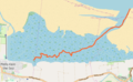
Cabbage Creek (orange line)
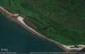
Tidal channel in mangroves
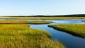
Tidal channels in a salt marsh
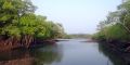
Tidal creek in mangroves
Hookton Slough, a channel in salt marshes
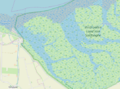
Channels in salt marsh, the Netherlands


