Tag:leisure=fitness_station
 |
| Description |
|---|
| An outdoor facility where people can practise typical fitness exercises |
| Rendering in OSM Carto |
| Rendering in OSM Carto |

|
| Group: sports |
| Used on these elements |
| Implies |
| Useful combination |
|
| See also |
| Status: de facto |
| Tools for this tag |
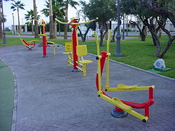
A fitness station (outdoor gym), calisthenics park or trim trail is an outdoor facility for a ![]() street workout. This can be a single training device, but also a collection of several devices. It is typically operated by a local government and free to use for everyone (usually 24/7), and can often be found along a fitness trail or in a park.
street workout. This can be a single training device, but also a collection of several devices. It is typically operated by a local government and free to use for everyone (usually 24/7), and can often be found along a fitness trail or in a park.
How to map
For an area with multiple devices, create an ![]() area of the grounds and tag it
area of the grounds and tag it leisure=fitness_station. Each individual fitness device and feature within the fitness station area should be mapped individually as a separate ![]() node with an additional
node with an additional fitness_station=<equipment_type> tag. If it is just a single fitness station device that is located somewhere (or the borders of multiple devices is unknown), you can place a single ![]() node in the middle and tag it
node in the middle and tag it leisure=fitness_station.
This is de facto scheme supported by iD (Rapid), Vespucci, SCEE (to note: all three support the key fitness_station=* only in combination with leisure=fitness_station).
To list multiple available equipments on a single object (if the exact location of the equipment is unknown or irrelevant – for example, there might be a lot of exercise equipment in a small area), two approaches can be used:
- Summary list with prefix
fitness_station:<equipment_type>=yes - Semi-colon value separator, e.g.
fitness_station=<equipment1>;<equipment2>;<equipment3>;...
If the fitness station is part of a fitness route, make it a member of a route=fitness_trail relation.
Useful combinations
sport=fitnessorsport=calisthenicsname=*– A name for the fitness stationref=*– A reference number of the fitness stationdescription=*– Additional descriptionopening_hours=*– Sometimes, the fitness station might not be open 24/7operator=*– E.g. the name of the local council which operates the fitness stationfitness_station=*– The type of fitness equipment(s) at the stationmanufacturer=*– Helps identify fitness station capabilitiesminimum_height_requirement=*– Some fitness stations may have minimum height requirement (of the body)lit=*– If the fitness station is lit
See also
fitness_station=*
leisure=fitness_centre– A fitness centre is a place with exercise machines and/or fitness/dance classes
leisure=playground- Relation:route – Definition of route relations
route=fitness_trail– Mapping routes with fitness stationssport=calisthenics


