User:TobiBS/Kosmos ICAO Map Germany Rules
Jump to navigation
Jump to search
Rules for a page based on OSM data that looks like the German ICAO Map: http://www.flightplanner.de/legenden/ICAOD.png
Options
| Option | Value | Comment |
|---|---|---|
| MinKosmosVersion | 2.1 | Minimal version of Kosmos needed to use these rules |
| LandBackgroundColor | #FFFFFF | |
| SeaColor | #C8E5FF |
Background areas
| Riverbank | waterway=riverbank |
Polygon (Color=#CADFF4) | |||
| Land | natural=land |
Polygon (Color=#FFFFFF) |
Grundlage/Basic
| River | waterway=river |
Polyline (MinZoom=6, Color=#C8E5FF, Width=2:1;17:8, Curved=true) | |||
| Wald1 Wood1 |
landuse=forest |
Polygon (MinZoom=6, Color=#D3EBBB) | |||
| Wald2 Wood2 |
landuse=wood |
Polygon (MinZoom=6, Color=#D3EBBB) | |||
| Wald3 Wood3 |
natural=wood |
Polygon (MinZoom=6, Color=#D3EBBB) |
Eisenbahn/Railway
| Eisenbahn1 Railway1 |
railway=rail |
Polyline (MinZoom=8, Color=#000000, Width=6:2;17:4) | EliminateSeams | ||
| Eisenbahn stillgelegt Railway disused |
railway=disused |
Polyline (MinZoom=8, Color=#000000, Width=6:2;17:4, DashStyle=Dash) | EliminateSeams |
Straßen/Streets
| Autobahnauffahrt Dual highway entry |
highway=motorway_link |
Polyline (MinZoom=8, Color=#FF0000, Width=6:2;17:4) | EliminateSeams | ||
| Autobahn Dual highway |
highway=motorway |
Polyline (MinZoom=6, BorderWidth=100%, BorderColor=#FF0000, Color=#FFFFFF, Width=6:2;17:4) | EliminateSeams | ||
| Fernverkehrsstraße1 Primary Road1 |
highway=trunk |
Polyline (MinZoom=8, Color=#FF0000, Width=6:2;17:4) | EliminateSeams | ||
| Fernverkehrsstraße2 Primary Road2 |
highway=primary |
Polyline (MinZoom=8, Color=#FF0000, Width=6:2;17:4) | EliminateSeams | ||
| wichtige Verbindungsstraße Secondary Road |
highway=secondary |
Polyline (MinZoom=8, Color=#FF0000, Width=6:1;17:2) | EliminateSeams |
Bebaute Gebiete/Built-Up Areas
| Großstadt City |
place=city |
Polygon (MinZoom=6, Color=#FFFF00, BorderColor=#606060, BorderWidth=6:1;17:1) Text (MinZoom=6, Color=#000000, TagToUse=name, FontName=Arial, FontStyle=bold, FontSize=6:10;17:12, TextMode=AreaCenter) |
|||
| Towntag |
place=town |
||||
| .Stadt Town 50.000 - 100.000 |
IsTaggedWith(e,"population") AND ValueNum(e,"population") > 50000 AND ValueNum(e,"population") <= 100000 | Polygon (MinZoom=6, Color=#FFFF00, BorderColor=#606060, BorderWidth=6:1;17:1) Text (MinZoom=6, Color=#000000, TagToUse=name, FontName=Arial, FontStyle=bold, FontSize=6:8;17:10, TextMode=AreaCenter) |
|||
| .Stadt Town 20.000 - 50.000 |
IsTaggedWith(e,"population") AND ValueNum(e,"population") > 20000 AND ValueNum(e,"population") <= 50000 | Polygon (MinZoom=6, Color=#FFFF00, BorderColor=#606060, BorderWidth=6:1;17:1) Text (MinZoom=6, Color=#000000, TagToUse=name, FontName=Arial, FontStyle=bold, FontSize=6:8;17:10, TextMode=AreaCenter) |
|||
| .Ortschaft1 Village1 5.000 - 20.000 |
IsTaggedWith(e,"population") AND ValueNum(e,"population") >= 5000 AND ValueNum(e,"population") <= 20000 | Symbol (MinZoom=11, Type=Circle, Size=11:6;17:8, Color=#FFFF00, BorderColor=#606060, BorderWidth=10%) Text (MinZoom=11, Color=#000000, TagToUse=name, FontName=Arial, FontStyle=bold, FontSize=11:6;17:8, TextLineOffset=-100%) |
|||
| Villagetag | place=village |
||||
| .Ortschaft2 Village2 5.000 - 20.000 |
IsTaggedWith(e,"population") AND ValueNum(e,"population") >= 5000 AND ValueNum(e,"population") <= 20000 | Symbol (MinZoom=11, Type=Circle, Size=11:6;17:8, Color=#FFFF00, BorderColor=#606060, BorderWidth=10%) Text (MinZoom=11, Color=#000000, TagToUse=name, FontName=Arial, FontStyle=bold, FontSize=11:6;17:8, TextLineOffset=-100%) |
Obstructions for low-flying charts
Tall buildings (building=* with height>...) should probably be marked here
| PowerLines | power=line |
Polyline (MinZoom=13, Color=#FF0000, Width=12:1;17:2) | |||
| PowerTower | power=tower |
Symbol (Type=Diamond, MinZoom=14, Color=#FF0000, Density=12:10;17:10, Size=14:4;17:4) | |||
| CableCars | aerialway=* |
Polyline (MinZoom=12, Color=#FF0000, Width=14:1;17:3) | |||
| Tower1 | tower=* |
Symbol (MinZoom=13, Type=Diamond, Size=14:1;17:8, Color=#FF0000) | |||
| Tower2 | man_made=tower |
Symbol (MinZoom=13, Type=Diamond, Size=14:1;17:8, Color=#FF0000) |
Tall buildings
| TallBuildings | IsTaggedWith(e,"height") AND ValueNum(e,"height") > 100 | Polygon (MinZoom=13, Color=#ff0000) |
Lufträume/Airspace
| Airspace | aeroway=airspace |
||||
| .Controlzone | class=D ctr=yes |
Polygon (MinZoom=8, MaxZoom=13, BorderDashStyle=Dash, Color=#60FF0000, BorderColor=#0000FF, BorderWidth=8:4;13:6) Text (MinZoom=8, MaxZoom=13, Color=#FF0000, TagToUse=class, TextMode=WayCenter, FontName=Arial, FontStyle=bold, FontSize=13:10;17:14, TextLineOffset=100%) Text (MinZoom=8, MaxZoom=13, Color=#FF0000, TagToUse=upper_limit, TextMode=WayCenter, FontName=Arial, FontStyle=bold, FontSize=13:10;17:14, TextLineOffset=0%) Text (MinZoom=8, MaxZoom=13, Color=#FF0000, TagToUse=upper_limitType, TextMode=WayCenter, FontName=Arial, FontStyle=bold, FontSize=13:10;17:14, TextLineOffset=-100%) |

| ||
| .Restricted | class=restricted |
Polygon (MinZoom=8, MaxZoom=13, BorderDashStyle=Solid, HatchStyle=BackwardDiagonal, Color=#0000FF, BorderColor=#0000FF, BorderWidth=8:4;13:6) Text (MinZoom=8, MaxZoom=13, Color=#0000FF, TagToUse=ref;class, TextMode=WayCenter, FontName=Arial, FontStyle=bold, FontSize=13:10;17:14, TextLineOffset=100%) Text (MinZoom=8, MaxZoom=13, Color=#0000FF, TagToUse=upper_limit, TextMode=WayCenter, FontName=Arial, FontStyle=bold, FontSize=13:10;17:14, TextLineOffset=0%) Text (MinZoom=8, MaxZoom=13, Color=#0000FF, TagToUse=lower_limit, TextMode=WayCenter, FontName=Arial, FontStyle=bold, FontSize=13:10;17:14, TextLineOffset=-100%) |

|
Meldepunkte/Reporting Points
| Meldepunkte VFR Reporting Points VFR |
aeroway=reportingpoint |
||||
| .Pflichtmeldepunkte Mandatory |
mandatory=yes |
Icon (MinZoom=9, MaxZoom=13, IconUrl=http://wiki.openstreetmap.org/images/e/e4/Reportingpoint_mandatory.png, Width=13:30;17:30) Text (MinZoom=9, MaxZoom=13, Color=#0000FF, TagToUse=ref, FontName=Arial, FontStyle=regular, FontSize=13:8;17:12, TextLineOffset=-200%) | |||
| .Meldepunkte auf Anforderung Not Mandatory |
mandatory=no |
Icon (MinZoom=11, MaxZoom=13, IconUrl=http://wiki.openstreetmap.org/images/f/f5/Reportingpoint.png, Width=13:30;17:30) Text (MinZoom=11, MaxZoom=13, Color=#0000FF, TagToUse=ref, FontName=Arial, FontStyle=regular, FontSize=13:8;17:12, TextLineOffset=-200%) |
Stuff within airports
This should go only on the approach plates, not on the navigation chart
| Apron | aeroway=apron |
Polygon (MinZoom=14, Color=#808080) | |||
| Taxiway | aeroway=taxiway |
Polyline (MinZoom=14, Color=#000000, Width=12:1;17:5) | |||
| Taxiway Text | aeroway=taxiway |
Text (MinZoom=14, Color=#000000, BorderColor=#E000000, BorderWidth=2, BackgroundColor=white, TagToUse=ref;name, TextMode=WayCenter, FontName=Arial, FontStyle=bold, FontSize=13:8;17:12) |
Helicopter facilities
Just default icon from Kosmos General Purpose Rules
| HelipadNode | aeroway=helipad |
Icon (MinZoom=12, IconUrl=http://wiki.openstreetmap.org/images/f/f7/Helipad20.png, Width=12:5;17:20) |
Runways
Note: these need to be not-to-scale later - the airport diagram comprising its runways needs to be a big symbol even at low zoom
| Runway | aeroway=runway |
Polyline (MinZoom=12, Color=#000000, Width=11:10;17:10) | |||
| Runway Text | aeroway=runway |
Text (MinZoom=14, Color=#000000, BorderColor=#000000, BorderWidth=2, BackgroundColor=white, TagToUse=ref;name, TextMode=AreaCenter, FontName=Arial, FontStyle=bold, FontSize=13:8;17:12) |
Airport labels
We need to be able to combine lots of different fields' data into one infobox for the airport, e.g. name, ICAO, IATA, frequencies, and put a border/background around the whole lot
| IcaoCode | aeroway=airport |
Text (MinZoom=9, Color=#3761DF, TagToUse=icao, FontName=Arial, FontStyle=regular, FontSize=9:11;17:15, TextLineOffset=60%) | |||
| AirportName | aeroway=airport |
Text (MinZoom=9, Color=#3761DF, TagToUse=name, FontName=Arial, FontStyle=regular, FontSize=9:11;17:15, TextLineOffset=-50%) |
TODO: does OSM use aerodrome (how quaint) or airport?
Low-zoom airport labels
| LowZoomAirport | aeroway=airport |
Text (MaxZoom=9, Color=#3761DF, TagToUse=icao, FontName=Arial, FontStyle=regular, FontSize=3:4;9:11) | |||
| LowZoomAirport2 | aeroway=aerodrome |
Text (MaxZoom=9, Color=#3761DF, TagToUse=icao, FontName=Arial, FontStyle=regular, FontSize=3:4;9:11) |
<--
Screenshots
-
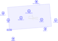 Control Zone and reporting points
 -
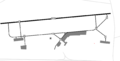 Taxiway markings


-->