JA:OSM-3D
|
このプロジェクト、特にウェブプラットフォームはオフラインです!古いバージョンのJavaをインストールした場合にのみ、オンラインで実行できます。 サーバーがクラッシュし、再度実行されるリソースがありません。ソースは次の週にgithubで利用できるようになる予定です。 |
![]()
For first results see Simple 3D Buildings.

OSM-3D.orgのプロジェクトは、OpenStreetMapのデータ上のWebベースのインタラクティブな3Dビューを提供することを目的とします。現在、ハイデルベルク大学のGIScience Group http://giscience.uni-hd.de によって維持管理されています。3Dマップの可能性と、標準化されたオープンインターフェイスを使用して3D空間データインフラストラクチャ(3D-SDI)を設定する方法を示すショーケースとして使用されます。パースペクティブエフェクトを作成するために、何らかの形で歪んだキャッシュされたタイルをレンダリングするだけでなく、標高モデルと、処理可能なOSMフィーチャを組み込んだシーングラフモデルに基づいています。このシーングラフは、オンラインビューアXNavigatorを使用して調べることができます。OSM-3Dで表示するOSMデータを準備するには、GIScienceのサーバーで行われる多くの前処理ステップが必要です。
プロジェクトのWebサイト: http://www.osm-3d.org
データの可用性
OSM-3Dという名前が示すように、マップのすべての機能はOSMからインポートされます。私たちは汎用の汎用3Dマップに組み込むことができる重要な機能をすべて抽出しようとしました。OSMはランドスケープモデルを提供しないため、高さの情報は別のソースからインポートされました。 地形モデルは国際農業研究協議グループ(CGIAR)がSRTM(シャトル レーダー トポグラフィー ミッション)のデータを親切に提供してくださりました。その解像度は90mで、CGIARは、山間部や水面上で補間技術を用いて発生した多くのデータのない空間を閉じました。元のSRTMデータセットは、均一分布点に依存しているため、地形三角形分割パッケージでは使用できませんでした。SRTMデータが利用できない北緯60〜86度および南緯60〜86度の極の領域には、解像度が1kmのより粗いデータセットであるGTOPO30データで埋められています。
地形は、OpenStreetMapの球状メルカトル参照システムと一致する長方形のタイルとして利用できます。レベル3〜13は完全に処理されましたが、レベル14〜18は要求に応じて計算され、キャッシュされます。そのため、最初に場所を訪問すると、読み込むのに少し時間がかかることがあります。
建物やPOIは世界中で処理され、定期的に更新されます。
結合されたOSMおよびSRTMデータセットは、Web 3Dサービス(W3DS)として再配布されます。 W3DSは、X3D、VRML、Collada、KMLおよびその他の3Dインターネット標準でエンコードされた地理空間データを配信するためのコンポーネントとして、現在オープン・ジオスペース・コンソーシアム(OGC)で3D描画サービスが検討されています。風景や都市のモデル、POIやラベルなどの情報レイヤーを提供するために設計されています。OSM-3DプロジェクトのW3DSは、OGC標準化プロセスの参考実装として利用可能になっています。詳細な情報、テストクライアント、およびインターフェイスのドキュメントは、次の場所にあります。
http://www.w3ds.org/doku.php?id=osm-3d_w3ds
地図の特徴
マップタイル
メルカトル投影で利用可能なすべてのタイルを使用できます。 現在、以下のスタイルが利用可能です:
- Mapnik
- Osmarender
- マップクエスト
- Mapquest Open Aerial
- Integrated DEM Style
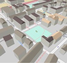
建物


建物は多面体としてレンダリングされ、平らな屋根を持つ押出型フットプリントが作成されます。ベースの高さはDEMから補完されます。OSMでは、ビルディングは、基底のフットプリントを表す方法として、または関係として、外側のリングと中庭のための0..nの内側のリングとモデル化されます。 内輪は正しく処理され、多面体に穴として表示されます。複数の方法で構成される外側のリングは処理できません。ボトムとトップは通常フラットです。屋根情報が利用可能である場合、アルゴリズムは、屋根の種類(例えば、吊り下げられたもの)および整列から屋根の幾何学を再構築しようとします。いくつかのケースでは、急な丘の上の建物が問題を引き起こし、部品が地面にぶら下がってしまいます。 このため、壁には建物としてタグを付けるべきではありません。ほとんどの場合、高さ情報は利用できないため、固定高さ値を使用する必要があります。利用可能な場合は、ビルディングジオメトリを構築するために次のタグが使用されます。
| キー | 説明 | 値の例 | ノート |
|---|---|---|---|
| height | おおよその高さ - 建物の地上から屋根までの距離(屋根、デフォルトでは高層ビルのアンテナまたは尖塔ではない) | デフォルトの単位は、メートル。3Dアプリケーションで使用する場合は、長さ測定の周知の略語を含みます。 | |
| min_height | 建物の構造物の下のおおよその高さ | 31 m | 張り出した部分や橋がある複雑な建物構造をモデル化するために使用できます。この値は、地面から建物の下端までの距離を指定します。別段の指定がない限り、単位はメートルです。min_heightを使用する場合、高さは地面から構造物の上端までの距離として定義されます。したがって、ブリッジの底部が地上100メートルに位置する3メートルの高さの「橋」は、高さ= 103、min_height = 100となります。 |
| building:min_level | 地上と実際の最初の既存階との間の階数 | 5 | 「空気中に浮かぶ」建物の部分(実際には、地面に固定されている他の建物部分でサポートされています)、存在しない地面からの階数。したがって、建物の下に通路がある場合、5階がない場合、建物を使用します:min_level = 5
ビルディング:レベルでは、地面からの床がまだカウントされていることに注意してください。また、存在しない「スキップされた」フロアも説明されています レベルの数に3mを掛けて実際の高さを見積もります |
| building:levels:aboveground | 建物の階数 | 50 | レベルの数に3mを掛けて実際の高さを見積もります |
| levels | 建物の階数 | 50 | 上記と同じ意味です。実際の高さを見積もるためにレベルの数に3mを掛けます |

注:一部のキーは冗長使用されています。距離単位(m、ft)での測定は、レベル数よりも優先され、それぞれ3メートルと見積もることができます。
高さキーの解析順序は、高さ、建物:レベル:地上、レベルです。
将来の現実的な都市モデルを実現するのに非常に役立つ可能性のある建物の属性の参照については、Building_attributesを参照してください。
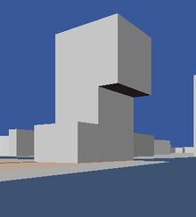
大きな建物では、それぞれ異なる高さの値を持つ複数のパーツに分割する方がはるかに優れています。さもなければ、地上平面はちょうど上のレベルの上に押し出され、奇妙に見えるかもしれません。フラットな屋根構造は、建物の複数のリングを使用して非常にうまくモデル化することができます(実際には、これは建物の一部であり、別のキーを見なければなりませんが、現在は建物に固執しています)。傾いた屋根はできません。
良い例:
文化科学宮殿、ワルシャワ、ポーランド。
オランダのアルメレにあるSilverline Tower。このように、min_levelタグはオーバーハング部分をモデル化するために使用されます。
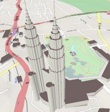
ペトロナスツインタワーズ、クアラルンプール、マレーシア。
ハイデルベルクの建物、ドイツ。


悪い例:
明らかに多くがあります。
Eiffel エッフェル塔、パリ。悪いツアーエッフェル。コメントについては、DE_talk:OSM-3D#Note_on_using_the_building_tagを参照してください。
聖ピーター大聖堂、バチカン。


Points of Interest
Point of Interest(POI)は3Dボックスとして表示され、シンボルはテクスチャおよびテキストラベルとして表示されます。POIは次のレイヤーで構成されています。
- Money(お金)
- Public Facilities(公共施設)
- Health(健康)
- Shop(お店)
- Traffic(交通)
- Eating(食べる)
- Enjoyment(楽しみ)
- Education(教育)
- Public Transport(公共交通機関)
- Post(郵便ポスト)
- Accomodation(宿泊施設)
Money
| Key | Value | Element | Rendering | Key | Value | Element | Rendering |
|---|---|---|---|---|---|---|---|
| amenity | atm |  |
amenity | bank |  | ||
| amenity | bureau_de_change |
This table is a wiki template with a default description in English. Editable here.
Public Facilities
| Key | Value | Element | Rendering | Key | Value | Element | Rendering |
|---|---|---|---|---|---|---|---|
| amenity | telephone |  |
amenity | toilets |  | ||
| amenity | courthouse |  |
amenity | police |  | ||
| amenity | public_building |  |
amenity | townhall |  | ||
| amenity | fire_station | amenity | place_of_worship |  | |||
| tourism | information |  |
This table is a wiki template with a default description in English. Editable here.
Health
| Key | Value | Element | Rendering | Key | Value | Element | Rendering |
|---|---|---|---|---|---|---|---|
| amenity | hospital |  |
amenity | pharmacy |
This table is a wiki template with a default description in English. Editable here.
Shop
| Key | Value | Element | Rendering | Key | Value | Element | Rendering |
|---|---|---|---|---|---|---|---|
| shop | supermarket |  |
shop | bakery |  | ||
| shop | butcher |  |
shop | kiosk |  |
This table is a wiki template with a default description in English. Editable here.
Traffic
| Key | Value | Element | Rendering | Key | Value | Element | Rendering |
|---|---|---|---|---|---|---|---|
| amenity | fuel |  |
amenity | parking |  |
This table is a wiki template with a default description in English. Editable here.
Eating
| Key | Value | Element | Rendering | Key | Value | Element | Rendering |
|---|---|---|---|---|---|---|---|
| amenity | fast_food | amenity | pub |  | |||
| amenity | restaurant |  |
amenity | biergarten | |||
| amenity | cafe |
This table is a wiki template with a default description in English. Editable here.
Enjoyment
| Key | Value | Element | Rendering | Key | Value | Element | Rendering |
|---|---|---|---|---|---|---|---|
| amenity | cinema |  |
amenity | theatre | |||
| amenity | nightclub |  |
This table is a wiki template with a default description in English. Editable here.
Education
| Key | Value | Element | Rendering | Key | Value | Element | Rendering |
|---|---|---|---|---|---|---|---|
| amenity | university |  |
amenity | school |  | ||
| amenity | library |  |
amenity | college |
This table is a wiki template with a default description in English. Editable here.
Public Transport
| Key | Value | Element | Rendering | Key | Value | Element | Rendering |
|---|---|---|---|---|---|---|---|
| highway | bus_stop | railway | tram_stop | ||||
| railway | tram | railway | subway_entrance | ||||
| railway | station | amenity | bus_station | ||||
| amenity | taxi |  |
This table is a wiki template with a default description in English. Editable here.
Post
| Key | Value | Element | Rendering | Key | Value | Element | Rendering |
|---|---|---|---|---|---|---|---|
| amenity | post_box | 
|
amenity | post_office |
This table is a wiki template with a default description in English. Editable here.
Accomodation
| Key | Value | Element | Rendering | Key | Value | Element | Rendering |
|---|---|---|---|---|---|---|---|
| tourism | hotel |  |
tourism | hostel | |||
| tourism | motel | tourism | guest_house |
This table is a wiki template with a default description in English. Editable here.
ラベル
ラベル(POI)は3Dテキストオブジェクトとして表示されます。ラベルは、次のレイヤーで構成されています。
- Suburb Labels(郊外のラベル)
- Building Labels(ビルディングラベル)
- Building Numbers(建物番号)
- County Labels(郡ラベル)
- Locality Labels(ローカリティラベル)
- Village Labels(村のラベル)
- Region Labels(地域ラベル)
- City Labels(市のラベル)
- Nature Labels(自然のラベル)
- Street Labels(道路のラベル)
Suburb Labels
| Key | Value | Element | Rendering | Key | Value | Element | Rendering |
|---|---|---|---|---|---|---|---|
| place | suburb | place | airport |
This table is a wiki template with a default description in English. Editable here.
Building Labels
| Key | Value | logical operator | Key | Value | Element | Rendering |
|---|---|---|---|---|---|---|
| building | yes or true | AND | name | any |
This table is a wiki template with a default description in English. Editable here.
Building Numbers
| Key | Value | logical operator | Key | Value | Element | Rendering |
|---|---|---|---|---|---|---|
| building | yes or true | AND | addr:housenumber | any |  |
This table is a wiki template with a default description in English. Editable here.
County Labels
| Key | Value | Element | Rendering | Key | Value | Element | Rendering |
|---|---|---|---|---|---|---|---|
| place | county |  |
This table is a wiki template with a default description in English. Editable here.
Locality Labels
| Key | Value | Element | Rendering | Key | Value | Element | Rendering |
|---|---|---|---|---|---|---|---|
| place | locality |
This table is a wiki template with a default description in English. Editable here.
Village Labels
| Key | Value | Element | Rendering | Key | Value | Element | Rendering |
|---|---|---|---|---|---|---|---|
| place | village |  |
place | hamlet | |
This table is a wiki template with a default description in English. Editable here.
Region Labels
| Key | Value | Element | Rendering | Key | Value | Element | Rendering |
|---|---|---|---|---|---|---|---|
| place | region |
This table is a wiki template with a default description in English. Editable here.
City Labels
| Key | Value | Element | Rendering | Key | Value | Element | Rendering |
|---|---|---|---|---|---|---|---|
| place | city |  |
place | town |  |
This table is a wiki template with a default description in English. Editable here.
Nature Labels
| Key | Value | Element | Rendering | Key | Value | Element | Rendering |
|---|---|---|---|---|---|---|---|
| natural | peak |  |
This table is a wiki template with a default description in English. Editable here.
Street Labels
道路のラベルは道路ネットワークから作成され、別のレイヤーとして表示されます。このレイヤーもタイル表示されています。つまり、ラベルは個々のフィーチャとしてではなく、長方形エリアのフィーチャのコレクションとして提供されます。フォントサイズはタイルレベルによって異なります。

| Key | Value | Element | Font Size / Tile Level | |||||||||
|---|---|---|---|---|---|---|---|---|---|---|---|---|
| 16 | 15 | 14 | 13 | 12 | 11 | 10 | 9 | 8 | 7 | |||
| highway | motorway | 18 | 33.6 | 62.4 | 115.2 | 211.2 | 384 | 768 | 1536 | 3072 | ||
| highway | trunk | 12 | 24 | 48 | 96 | 192 | 384 | |||||
| highway | primary | 12 | 24 | 48 | 96 | 192 | ||||||
| highway | secondary | 12 | 24 | 48 | 96 | |||||||
| highway | tertiary | 12 | 24 | 48 | ||||||||
| highway | residential | 12 | 24 | |||||||||
| highway | living_street | 12 | 24 | |||||||||
| highway | service | 12 | 24 | |||||||||
| highway | pedestrian | 12 | 24 | |||||||||
| highway | footway | 12 | 24 | |||||||||
This table is a wiki template with a default description in English. Editable here.
技術設備
いくつかの人工物は、通常、同様の形と色を共有しているため、3Dシンボルとして表示することができます。
| Key | Value | Element | Rendering | Key | Value | Element | Rendering |
|---|---|---|---|---|---|---|---|
| man_made | lighthouse |  |
man_made | windmill | |||
| power_source | windgenerator |
This table is a wiki template with a default description in English. Editable here.
マップの機能
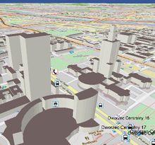
マップを表示してナビゲートするだけでは、OSM-3Dプロジェクトの唯一の目的ではありません。地物情報へのアクセス、場所とルートの検索、独自のトラックのインポート、およびマップとのその他のやりとりも重要です。これらの機能のほとんどは、オープンなOGCインターフェイスを備えた特殊なジオサービスに接続することで実現しています。OGCサービスを使用すると、コンポーネントを簡単に置き換えることができるという利点があります。たとえば、OSM以外のローカルのデータを扱うサードパーティのOGCサービスを接続できます。これらのサービスは、空間データインフラストラクチャの実際のビルディングブロックです。しかし、通常、ジオ・サービスは2Dデータを提供します。ジオコーダーは最も可能性の高い2D座標を提供します。仮想ランドスケープモデルと一緒に表示するには、高さを追加のソースから取得する必要があります。この目的のために、DEMからの高さ値を補間するElevation Query Service(EQS)を設定しました。EQSには、三角形分割されたSRTMデータを含むPostGISデータベースが含まれています。
次のプラグインは、XNavigator Webstartエディションで使用できます。「パネル」メニューで有効にする必要があります。
Get Feature Info
GetFeatureInfo is an operation of the W3DS. You can click on the map and will receive a list of attributes of the selected feature.
Geocoder
Geocoder is a common component in map applications. It allows to search for places and addresses. The Reverse Geocoder receives coordinates and looks up the address in the database. Click on a building and the address will pop up.
POI Search

Convenient function to search for POIs. All OSM POIs have been categorized, spatially indexed, and stored in a PostGIS data base. Access to this data base is enabled through an OGC Directory Service. The POI search panel ("Yellow Pages") offers a list of all available categories and sub types. Click on the map, specify a search radius, select either a category or a single feature type, and you will see all nearby POIs that match your query.
3D Routing

Routing allows to find shortest or fastest connections between two points. The 3D route service (3DRS) is a special modification of the service used in OpenRouteService. It supports several modi: fastest route for cars, shortest route for cars, routes for pedestrians, and routes for bicycles. All these modes can be used in OSM-3D. The 3DRS delivers, in contrast to the normal RS, 3D line strings in the route description, which can be easier imported and displayed together with the DEM. You can either pick two arbitrary points, or specify addresses for the start and end point.
GPX Import
If you have recorded your own GPS tracks, you can upload the GPX file and display the track in OSM-3D.
Access to Sensor Data
Sensor data can be obtained from an OGC Sensor Observation Service (SOS). The display of sensor data includes a 3D symbol representing the sensor category and a list of values which were recently recorded by the sensor. The SOS contains environmental sensor data collected from another source.
OSM-3D Client Software
The web client that is used in OSM-3D is called XNavigator. It has been mainly developed as client for the W3DS reference implementation, but it also allows access to a couple of complementary OGC services. Hence it is sometimes also referred to as "integrated client", but in the OSM-3D project its main purpose is to fly through the city and landscape models without the need to install or configure anything.
XNavigator can be used in 3 ways:
- as Applet embedded in a webpage. This is the simplest version. Selection and configuration of layers is fixed and cannot be changed. Permalinks can be created and distributed. The Applet provides an External Authoring Interface (EAI) giving a limited access to internal functions. See OSM-3D Applet page for details.
- as Java Webstart. This gives you a complete GUI and full access to layers, settings, and map functionalities, including routing, geocoding, sensor data access and others. As additional navigation mode a 2D overview map can be used.
- as installation. Same as Webstart, but without restrictions. Webstart is running in a sandbox environment with limited access to system resources. With the installation you can also import models from your local hard drive. The installation is sometimes faster than Webstart, therefore it is the recommended version.
XNavigator homepage: http://xnavigator.sourceforge.net/doku.php
Data Updates
It does not update anymore. --Henriko 11:48, 29 April 2011 (BST)
yes, we are doing updates: Buildings, POIs, labels etc. are updated approx. weekly or more often. But: Landuse & streets are only updated occasionally at the moment (very rarely) az 15. July 2011
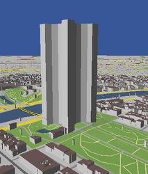
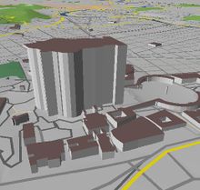
Some Interesting Places
City of Rostock
The first complete city model in OSM-3D was made available for the City of Rostock. In April 2009, The Land Surveilling Office (Kataster-, Vermessungs- und Liegenschaftsamt - KVL) of Rostock donated all their building data to OSM. The building footprints have been slightly simplified and have an accuracy of <= 1m, which is sufficient for an LOD-1 (see CityGML) city model. On request of the University of Bonn, they also provided building height information which could be imported in August 2009. For more information on the data import see Rostocker Gebäudehöhen Import 2009.


Screenshots
more OSM-3D Screenshots
Servers
OSM-3D is running on several servers installed in the Computing Center of the University of Heidelberg (URZ).
| Server | Function | Configuration | System |
|---|---|---|---|
| rax | Application server
Proxy for internal services |
CPU: 2 x Intel Xeon X5355 @ 2.66GHz
HDD: 2 x 250GB SATA 7.2k in RAID 1 RAM: 16 GB |
Windows Server 2003 Enterprise x64 Edition
Java SE 6 Apache 2.2 HTTP Server Several Apache Tomcats |
| feldberg | Data processing server
Used for updates |
CPU: 2 x Intel E5440 @ 2.83GHz, Hyperthreading off
HDD: 2 x 300GB SAS RAM: 48 GB |
Ubuntu
PostGreSQL 8.4 Java SE 7 |
| zimba | Database server | CPU: Intel Core 2 Quad Q6700 @ 2.66GHz
HDD: 4 x 2TB SATA 5.4k. 3 of them in S/W RAID 0 RAM: 4 GB |
Debian Squeeze
PostGreSQL 8.4 |
| nebelhorn | Update server. Dedicated to building updates | CPU: Intel Pentium Dual-Core @ 2.50GHz
HDD: 250 GB RAM: 2 GB |
Windows XP
Java SE 6 |
This table is a wiki template with a default description in English. Editable here.
Statistics
As of 02/14/2012:
  Buildings: 50.043.209 / 76 GB
  Point Objects: 3.514.446 / 1GB
  Terrain Tiles: 68.562.212 / 398GB
  Total Database Size: 475GB
  Processing Database Size: 1425GB
As of 01/15/2011:
  Buildings: 23.262.900
  Point Objects: 5.659.070
  Terrain Tiles: 120.030.291 / 513GB
  Total Database Size: 572GB
  Processing Database Size: 1425GB
As of 07/20/2010:
  Buildings: 2.378.301
  Point Objects: 5.659.070
  W3DS Database Size: 99 GB
  Processing Database Size: 306 GB
Links
- OSM-3D_Applet
- Proposed_features/Building_attributes
- 3D_Development
- 3D_Development/Modelling
- 3D_Development/Tagging
- Indoor
- ProposedRoofLines
External links
- http://www.osm-3d.org
- OSM-3D in action: http://www.youtube.com/watch?v=TK85iSeLrGY
- http://srtm.csi.cgiar.org
- http://www.geog.uni-heidelberg.de/giscience.html
- http://www.w3ds.org
- http://xnavigator.sourceforge.net/doku.php
- http://sourceforge.net/projects/xnavigator/
| XNavigator | |
|---|---|
 | |
| 作者: | User:Aschilli |
| ライセンス: | GNU General Public License v2 |
| 動作環境: | Java |
| 版数: | 1.4.1 (2012-02-26) |
| 言語: | ドイツ語 および 英語 |
| ウェブサイト: | http://xnavigator.sourceforge.net/doku.php |
| プログラミング言語: | Java |
|
3D OSM viewer using SRTM DEM, Routing with OpenRouteService | |