Ko:Key:expressway
 |
| 설명 |
|---|
| 높은 설계 속도와 인접한 자산으로의 제한된 접근성을 가진 도로. 보통은 통행방향이 분리되어 있음(dual-carriageway). |
| 그룹: 도로 |
| 해당 요소의 사용 |
| 의존하는 태그 |
| 같이 보기 |
| 상태:사실상 표준 |
| 이 태그를 위한 도구 |
고속화도로는 높은 주행 속도를 위해 설계되었지만 고용량의 고속 교통을 안전하게 처리하기 위한 motorway=*나 highway=motorway 태그의 특성이 부족한 도로입니다.
이 키의 목적상, 고속화도로가 반드시 용어 expressway의 일상적 의미와 일치하지는 않습니다. 넓게는 이 키는 이 용어가 미국과 영국의 교통공학자에 의해 어떻게 사용되는지에 대응합니다. 하지만, 이 키는 motorway=*를 의미하지는 않습니다. 고속도로와 비슷한 종류인 고속화도로는 몇몇 국가에서 정부에 의해 공식적으로 인정되기도 합니다. 고속화도로는 motorroad=yes(자동차전용도로)와 겹치기도 하지만, 두 개념이 동일하지는 않습니다.[1][2]
OSM에서 정의된 대로, 이 키는 용어 "expressway"에 대해 다른 국가에서 사용되는 것처럼 특정한 일반적 의미를 나타내지 않습니다. 가령, 이것은 super-2's를 제외합니다.
특성
고속화도로의 특성을 정의하는 것은 도로에 따라 모순이 존재합니다. 일반적으로 고속화도로의 전반은:
- 방향이 분리된 도로입니다 (divided highway,
dual_carriageway=yes) - 일반 도로보다 높은 제한 속도와 고속도로 양식의 도로 표지판과 같은 설계 요소를 수반합니다.
- 인접한 자산에 대해 제한된 접근성을 가집니다. (
access_control=partial) (예를 들어, 측도나 우측 진출입 교차로를 통하여)
고속화도로는 입체교차로에서 연결로(램프)를 통해 몇몇 주요 도로를 연결할 수 있지만, 다른 공공 도로와의 신호등이 있거나 없는(highway=traffic_signals) 평면 교차로가 있을 수 있습니다. 이 부분은 완전히 입체교차되어 있는 고속도로와의 차이입니다.
몇몇 지역에서는 종종 한 도로에 highway=trunk와 expressway=yes가 동시에 나타나지만, 두 태그는 동일하지 않습니다. 지역의 태깅 관습에 따라, highway=trunk 태그는 고규격 또는 높은 중요성의 도로에 사용될 수 있습니다. 그래서 고속화도로는 highway=primary가 될 수도 있고, highway=trunk가 expressway=no일 수도 있습니다. (고속화도로는 고규격의 도로이지만, 중요성은 다를 수 있음)
고속 주행을 보장하기 위해, 고속화도로는 주로 보행자(foot=*)나 자전거(bicycle=*)와 같은 저속 교통수단의 접근을 제한합니다. 하지만 고속화도로마다 다른 접근 제한을 가질 수 있기 때문에, 데이터 소비자들은 expressway=yes 태그만을 가지고 특정한 접근 제한을 추론하지 말아야 합니다. 적용 가능한 국가의 경우 motorroad=yes 태그를 사용해 고속화도로에 보편적으로 적용되는 접근 제한의 종류를 간결히 나타내세요. 반대로 이러한 접근 제한이 고속화도로의 조건을 충족하지 않는 도로에도 적용되는 경우가 있으므로, 데이터 소비자는 motorroad=yes 태그가 고속화도로를 의미한다고 추정해서는 안 됩니다.
2차로 고속화도로
expressway=yes 태그는 왕복 2차로인 고속화도로에도 사용될 수 있습니다. 이 종류의 도로는 dual carriageway(통행방향 분리)가 아닙니다만, 일반적으로:
- 일반 도로보다 높은 제한 속도와 고속도로 양식의 도로 표지판과 같은 설계 요소를 수반합니다.
- 전 구간이 진출입 램프가 있는 나들목으로 입체교차되어 있고, 인접한 자산에 곧바로 접근할 수 없습니다. (
access_control=full)
2차로 고속화도로는 한편으로 통행방향이 분리되어 있다면 고속도로가 될 수도 있는 도로입니다.
판단 방법
| 방향이 분리된 도로 | 방향이 분리되지 않은 도로 | |
|---|---|---|
| 접근 제한 없음 | expressway=no
|
expressway=no
|
| 접근 제한 있음 | expressway=yes
|
expressway=no
|
| 부분적 접근 제한 | expressway=yes
|
expressway=no
|
| 완전한 접근 제한 | highway=motorway( expressway=yes 암시됨)
|
expressway=yes
|
용어의 정의
접근 제한 없음
대부분의 시내 도로들과 평면교차하고, 서비스 도로나 진입로를 통해 집이나 토지같은 인접한 자산에 곧바로 접근할 수 있습니다.
접근 제한 있음
통과 교통에 대한 간섭을 최소화하는 한도로만 교차로가 존재합니다. 인접한 자산으로의 접근은 도로의 바깥쪽으로 진출입하는 방식으로만 이루어지거나, 진입로가 적거나 때로는 없습니다. 교차로는 대부분 평면교차로입니다.
부분적 접근 제한
일부 접근은 우측 진출입로 또는 램프를 갖춘 입체교차로를 통해 이루어지지만, 나머지 접근은 평면교차로를 통해 이루어집니다. 통과 교통에 대한 간섭을 최소화하는 한도로만 교차로가 존재합니다. 인접한 자산으로의 접근은 도로의 바깥쪽으로 진출입하는 방식으로만 이루어지거나, 진입로가 적거나 때로는 없습니다.
완전한 접근 제한
모든 접근이 램프를 갖춘 입체교차로를 통해서만 이루어집니다. 입체교차로만 존재하며, 인접한 자산으로 곧장 접근할 수 없습니다.
방향이 분리된 도로
중앙분리대나 다른 물리적 방벽으로 양 방향의 교통이 완전히 분리되어 있습니다.
방향이 분리되지 않은 도로
양 방향으로 차량이 다닙니다. 칠해진 선이나 기타 물리적이지 않은 수단으로만 분리되어 있습니다.
Rationale
북아메리카에서는, "고속화도로"라는 용어는 위의 정의를 반드시 충족하는 잘 만들어진 교통공학 전문 용어입니다. 미국에서는, "고속화도로"라는 용어가 Manual on Uniform Traffic Control Devices와 연방 도로 행정기관의 다른 출판물에서 사용됩니다. 예를 들어, 도로 상태 모니터링 시스템에서는 고속화도로를 이렇게 정의합니다:
- 부분적 접근 통제가 있는 분리된 도로 시설물[3]과 각 방향에서 통과 교통만을 위한 2개 이상의 차로; 대부분의 주요 교차로에서의 입체교차를 포함합니다.
외관 상 미국 과학학술원의 운수 연구회가 출판한 Highway Capacity Manual의 엄격한 기준에 따라 도로를 고속화도로로 분류하는 것은 개별 도로관리기관에 달려 있습니다. MUTCD의 정의에 근거해, 고속화도로는 부분적으로 표지판으로 안내되기도 하지만 항상 그렇지는 않습니다. 몇몇 도로가 표지판으로 안내됨은 Verifiability이라는 개념에 부합하지만, 태그가 데이터 사용자에게 유용하기 위해서는 고속화도로임이 암시되는 곳을 포함해 도로 네트워크 전반에 일관성있게 적용되어야 합니다.
렌더링
expressway=yes 태그는 렌더링을 의도하였습니다. 이 키는 관습적으로 도로 지도에서 고속도로와 일반 도로로부터 고속화도로를 별도의 색이나 선 모양으로 구분시키던 미국에서 시작되었습니다. 이 구분을 통해 지도는 고속도로가 지나지 않는 지역을 통과하는 전통적인 경로를 강조하면서도 운전자들에게 이 길이 덜 안전하고 나쁜 주행경험을 제공하며 자전거나 보행자에게는 합법일지라도 매우 위험함을 알릴 수 있습니다. 만약 일반 도로가 일부 구간에 한해 고속화되고 있거나, 비슷하게 고속화도로가 고속도로로 승격되고 있다면, 전체 구간의 일관성을 고려하지 않고 전통적인 지도에서 대안적인 선으로 나타날 수 있습니다. 이 대안적인 효과는 고속화도로를 구분하는 지도에서만 예측될 수 있습니다.
도로 분류와 같은 지도 제작의 다른 측면에서, 고속화도로 태그는 뭔가 주관적일 수 있습니다. 그러므로, 이 키는 고속화도로가 명시적으로 안내되고(미국처럼 더 부분적으로) 교통공학 실험이나 지도 제작 관습에 의해 지지되는 국가에서 더 적절합니다.
경로 탐색
경로 탐색기는 램프와 회전 채널(분리된 회전 차로)을 구분하는 방법이 필요합니다. 이들은 둘 다 highway=trunk_link로 태그될 수 있습니다. 이상적으로는, 연결된 교차로에서 회전할 때 경로 탐색기가 고속도로나 고속화도로와 달리 일반 도로를 따라 회전 차로를 안내합니다. 역사적으로, Valhalla와 같은 경로 탐색기는 부정확하게 highway=trunk에 연결된 highway=trunk_link를 램프로 간주하는 방법을 사용하였지만[2], 이 추정은 highway=trunk가 연결성에 근거해 태깅된다면 실패하게 됩니다.
만약 사용자가 경로를 탐색할 때 고속도로를 피하기로 선택한다면, 탐색기는 비슷한 특성을 가진 고속화도로도 피하려고 시도합니다. 역사적으로, OSRM과 같은 경로 탐색기는 이를 위해 부정확하게도 highway=trunk와 highway=trunk_link로 고속화도로를 판단했습니다. [3]
매핑 방법
만약 highway=* 태그가 있는 선이 위의 조건을 만족하고 고속화도로가 명시적으로 태그되어야 한다는 지역적 합의가 있다면, 길에 expressway=yes를 추가하세요. 만약 highway=trunk이지만 위의 조건을 전혀 만족하지 않는다면, expressway=no 태그를 사용하여 데이터 소비자가 역사적 이유로 그 도로가 고속화도로라고 추정하는 것을 방지할 수 있습니다.
expressway=*에 더해서, 태깅을 정당화하고 경로 탐색기에 도움을 주기 위해 더 객관적인 태그를 추가할지 생각해 보세요.
dual_carriageway=yesoneway=yes도로가 물리적인 중앙분리대를 통해 방향별로 분리되어 있는 경우.maxspeed=*탐색기가 도로 분류에 근거해 제한속도를 잘못 추정하지 않게 해 줍니다.highway=motorway_junction출구 램프 표지판이 세워진 램프가 분기하는 곳.highway=traffic_signals신호가 있는 평면교차로.
누가 이 도로를 이용할 수 있는지 분명히 하기 위해 접근 태그를 추가하세요. 특히 빈 협약에 따른 표지판이 있는 몇몇 지역에서는 motorroad=yes가 적절한 태그일 수 있습니다.
태그가 사용되는 곳
대한민국
대한민국에서는 고속화도로에 대해 법적으로 정의하고 있지는 않습니다. 보통 신호등이 없고, 제한속도가 높고, 입체교차로로 이루어져 교통 흐름이 끊기지 않는 일정 길이 이상의 도로를 고속화도로라고 부릅니다. 지역의 매핑 관습에 따라, highway=trunk는 고속화도로를 나타내는 태그입니다. 이 태그가 적용되는 구간에는 expressway=yes 역시 함께 적용되어 있습니다. 대부분의 고속화도로는 동시에 자동차 전용도로이지만, 모든 고속화도로가 자동차 전용도로인 것은 아닙니다. 따라서 자동차 전용도로에는 motorroad=yes 태그를 추가로 붙여 나타냅니다.
미국

In the United States, the expressways in a given state or county do not necessarily correspond to a single road classification or designated route network. An expressway may be built for a variety of reasons, including as a stage of construction before upgrading to a freeway, as a workaround for lack of space, or as a political compromise. When an expressway becomes a conventional surface street, the MUTCD calls for a large warning sign to indicate the end of the expressway. Otherwise, the entrances to an expressway are not signposted as such, so an expressway that connects two freeway segments would not have any sign explicitly referring to it as an expressway. However, the road would have guide signs in the style that the MUTCD reserves for freeways and expressways as opposed to conventional roads.
Public awareness of the term "expressway" varies across the U.S. In western states, such as California, a typical motorist is familiar with the distinction between freeways and expressways and uses both terms regularly. Elsewhere, "expressway" has a much broader colloquial definition that is not covered by this tag. As a standard street suffix, it can appear in the name of a variety of roads from freeways to conventional surface streets that lack access control,[3] grade-separated interchanges, or high-speed design. Do not confuse this colloquial definition with the technical one above.
Regional variation in road design can also be a deciding factor. True expressways are rare in the northeast United States, however some roads such as US 11/15 along the Susquehanna River in central Pennsylvania, as well as parts of US 22 in western Pennsylvania, can be said to be "expressways" relative to the typical regional road network.
expressway=yes can also refer to a "Jersey freeway", which is a divided road (typically a jersey barrier and narrow overall footprint) with high-speed design and grade separations. Unlike a standard expressway, however, it does have frequent access to adjacent properties, but has few or no at-grade intersections with other public roads.
Unlike motorroad=yes, expressway=yes does not imply access restrictions by default. Explicitly add access tags to an expressway based on signs posted at entrance ramps.
캐나다
Usage of the tag in Canada is similar with the United States.
Public awareness of expressways varies across regions and provinces. In the Prairie provinces (Alberta, Saskatchewan, Manitoba) and parts of Ontario, a typical motorist is familiar with the distinction between freeways and expressways, and uses both terms regularly. In Alberta, expressway- or freeway-grade roads in cities such as Calgary usually have names bearing the suffix "Trail". In Ontario, roads considered expressways under the technical definition usually include RIRO (right-in, right-out) expressways such as parts of Highway 11 north of Barrie and Highway 35/115 in Durham Region, as well as some roads suffixed "Parkway" such as the Hanlon Parkway in Guelph and the Veterans Memorial Parkway in London. Elsewhere, the term has a broader colloquial definition that is not covered by this tag. As a standard street name suffix, it can encompass freeway-grade roads (e.g. the Gardiner Expressway in Toronto) to roads lacking control of access, grade-separated interchanges and high-speed design features. In Quebec, "expressway" is also used as a translation of French autoroute by English-speaking Québécois.
Regional variation in road design can also be an deciding factor. True expressways are common in the western prairie provinces and parts of rural Ontario, but are somewhat less common in Quebec and the Atlantic provinces.
Curaçao (the Netherlands)

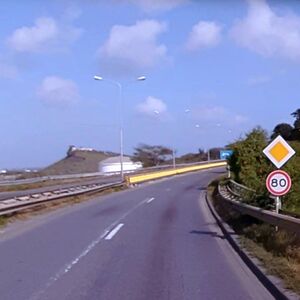
Curaçao legislation, similar to The Netherlands, defines a motorroad traffic sign with access restrictions and an elevated default speed limit. However the island country has roads without the motorroad traffic sign, without motorroad access restrictions, but with the motorroad elevated default speed limit (via a speed limit traffic sign). These are tagged with highway=trunk, motorroad=no, expressway=yes.[5]
인도
- 주요 문서: India/Tags/Highway
In India, this tag has been used to tag higher-quality dual-carriageway highways in parts of the country, such as highways forming the Golden Quadrilateral connecting India's major cities (Delhi, Mumbai, Chennai, Kolkata). This does not correspond to the common Indian English usage of "expressway", which usually refers to controlled-access highways (highway=motorway) such as the Mumbai–Pune Expressway.
사용하지 않는 곳
폴란드
In Poland, tag expressways as motorroad=yes instead of expressway=yes[6] because Polish expressways have access restrictions similar to motorways.
예시
- Aerial examples
-
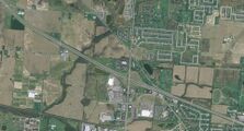
오하이오 주 카날 윈체스터 인근 미국 33번 국도의 교외 고속화도로 부분. 주요 도로와의 불완전 클로버형 교차로를 보면, 비주요 도로는 평면 교차로 접속하고 있습니다.
-
A conventional surface road segment of U.S. Route 40 near Alton, Ohio. Note the frequent driveway access.
- Street-level examples
-
A rural expressway segment of the Appalachian Highway in Carthage Township, Athens County, Ohio. Except for the at-grade intersections with township roads, this segment would meet the criteria for a motorway.
-
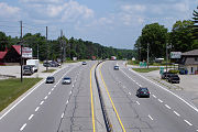
An urban expressway segment of King's Highway 11 in Severn, Ontario. Note the driveway access immediately preceding the exit ramp.
-
An urban expressway segment of Lawrence Expressway in San Jose, California. Due to the high speed limit (even at this traffic signal), the curve in the road is relatively gentle.
-
An urban expressway segment of Foothill Expressway in Palo Alto, California. Note the freeway-style guide signs and the median separating northbound and southbound traffic, but also the bike lane.
시골 고속화도로:
- US 33 in parts of Ohio
- US 48 in West Virginia
- Much of US 15 between Frederick, MD and Harrisburg, PA
도시 고속화도로:
- SR 161 in Columbus, Ohio
- US 222 around Trexlertown, PA near Allentown
- US 29 in Maryland between MD 650 and MD 32
- Santa Clara County expressway system
Jersey freeways:
- US 11/15 between Duncannon and Selinsgrove in Pennsylvania
- US 46 and NJ 3 between I-80 and NJ 21
- NJ 17 between NJ 3 and I-287
역사
As far back as 2009, there was consensus among mappers in the United States to tag expressways as highway=trunk, regardless of connectivity. This U.S.-centric definition of a trunk road has been questioned on numerous occasions even by U.S.-based mappers, in part because it leads mainstream renderers to treat some Midwestern road networks inconsistently. In 2021, an extended discussion in several venues led to a proposed redefinition of trunk roads that would divorce it from the physical characteristics of an expressway, relegating this distinction to a secondary tag.
The idea for a dedicated key for expressways came out of a 2009 essay by a mapper from Ohio, where expressways are common but motorists have no colloquial term for them. The following year, this key was introduced on 200 ways and a a formal proposal was discussed. Neither it nor a companion proposal about substandard or isolated motorways ever came to a vote. Nevertheless, the key began picking up usage in early 2012, increasing to about 1,400 ways in Ohio and Texas before levelling off. It spread to Pennsylvania in 2017. In 2018, usage began to climb at a much faster pace. [4][5][6] This increase was noted in early 2021 in a discussion about whether the key would also be applicable to Brazil. [7]
소프트웨어 지원
iD 에디터에서, 미국의 간선 도로와 1차 도로 프리셋에는 "고속화도로"[7] 체크박스가 있습니다. [8]
OpenMapTiles는 이 태그를 transportation 레이어에 노출하고 있습니다.[9] OpenStreetMap Americana는 고속화도로를 도로 분류에 따라 빨간색이나 검은색의 윤곽선이 있는 선형으로 표시합니다.[10] OpenTrailStash는 고속화도로를 trunk/motorway 와 primary/secondary 사이의 주황색으로 렌더링합니다.[11]
Apache Baremaps (OpenStreetMap Carto)와 OpenStreetMap Americana가 인디애나폴리스 인근 고속화도로를 어떻게 처리하는지 비교해보세요:
다른 소프트웨어에서의 지원에 대해 미국의 매퍼들이 요청했습니다.
각주
- ↑ “Express road”. Glossary for transport statistics. Luxembourg City: Publications Office of the European Union. 2019. p. 34.
- ↑ “Express road”. Statistical Terms Glossary. Beirut: United Nations Economic and Social Commission for Western Asia. Retrieved October 3, 2024.
- ↑ 3.0 3.1 이 맥락에서 접근 통제는 자동차 운전자가 다른 도로나 인접한 자산(건물, 땅)으로 접근하는 것을 방지하는 척도를 뜻합니다. 도로의 통행 제한을 나타내는 것이 아닙니다.
- ↑ A similar sign exists in New Zealand, where "expressway" contrasts with "motorway". However, the meaning of these two terms in NZ English has no correlation to what the terms mean in OSM.
- ↑ The Netherlands roads tagging
- ↑ Road tagging in Poland
- ↑ 현재 고속도로로 되어 있으나, 오역이며 수정 중에 있습니다.


