Proposal:Location transitions
| The Feature Page for this approved proposal is located at Tag:location:transition=yes |
| Location transitions | |
|---|---|
| Proposal status: | Approved (active) |
| Proposed by: | Fanfouer |
| Tagging: | location:transition=yes
|
| Applies to: | |
| Definition: | Mapping location change between features |
| Statistics: |
|
| Draft started: | 2015-08-12 |
| RFC start: | 2015-08-12 |
| Vote start: | 2016-01-09 |
| Vote end: | 2016-01-23 |
Proposal
Rationale
Many features can be described with location=* on OSM as for indicating where those features can be seen.
The location of long linear infrastructures like power=cables, man_made=pipelines and even highway=motorways can change sometimes.
It is proposed to use the location:transition=* on nodes where location changes occur.
At such places, several OSM features with different locations are connected to each other.
location:transition=* can enable mappers to indicate the location is changing without describing all features involved (mainly for verifiability/visibility reasons)
Currently, location transitions can be gathered by location=* values comparison on two or more connected map features (often ways). Sometimes, underground part can't be mapped due to lack of information (or verifiability principle violation) and the transition isn't complete. This key is intended for such cases.
This will be certainly more sustainable than using fixme=continue or other temporarily stuff both regarding data consumers and other mappers.
Scope
This proposal is firstly intended for power networks and pipelines where more specialized keys can currently be found.
Nevertheless, this key may be used in many other field of knowledge when applicable.
Tagging
Tagging may be really simple : just add location:transition=yes on the node connecting two or more features with different locations.
In case of one side can't be mapped due to its non-verifiable location, just add location:transition=* at the end of features linked to the transition.
yes is currently the only valid value, but a few more can obviously be added for special needs.
- Requests may be mainly interested to check if
location:transition=*exists on features without focusing on any particular value. location=transitionshouldn't be used since transition isn't a proper location for features.
Equivalent values
Here are the keys or values which mean the same as location:transition=yes, on power features only. They can be left on features or replaced depending on mappers needs and views.
The proposed key os more global and apply to many more cases than the ones below.
| Specialized value | Used for ? | More global tag to use | Taginfo usage as of 22nd December 2015 |
|---|---|---|---|
tower=air_to_ground |
A transition between overhead power line and underground cable | location:transition=yes |
516 |
tower=location_transition |
A transition between overhead power line and underground cable | location:transition=yes |
23 |
tower=transition |
A transition between overhead power line and underground cable | location:transition=yes |
1305 |
pole=location_transition |
A transition between overhead power line and underground cable | location:transition=yes |
264 |
pole=transition |
A transition between overhead power line and underground cable | location:transition=yes |
3546 |
Examples
As explained in Scope chapter, this proposal is intended for power networks and pipelines.
Nevertheless, location:transition=* is a far more global key and should be used in any field of knowledge, depending on opportunities.
Feel free to complete this examples section.
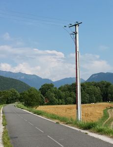
Power
- A line goes underground
 |
- |  |
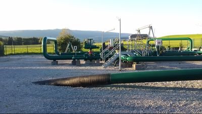
Pipelines
- A pipeline goes underground
 |
Telecom
- Submarine cables cross shores (
location=underground) to reach the sea (location=undersea) and then may be burried under the ocean floor offshore (location=underground).
Those successive parts underground/undersea/underground only exists because ships can't tow burying machines to the ground as shown on the example picture.
Voting
On January 26 2016, 14 pros against 2 cons (87.5% of approval) make this proposal accepted by the community.
Vote is now over.
 I approve this proposal. Mateusz Konieczny (talk) 12:04, 9 January 2016 (UTC)
 I approve this proposal. Polarbear w (talk) 12:28, 9 January 2016 (UTC)
 I approve this proposal. User 5359 (talk) 14:07, 9 January 2016 (UTC)
 I approve this proposal. Should explicitly deprecate
 pole=transition, though, as this tag is used by some contributors, like me, to map this on power poles. Penegal (talk) 18:04, 9 January 2016 (UTC) I approve this proposal. --Lks1 (talk) 14:22, 11 January 2016 (UTC)
 I approve this proposal. BushmanK (talk) 18:18, 14 January 2016 (UTC)
 I approve this proposal. Species 18:35, 14 January 2016 (UTC)
 I approve this proposal. --Klumbumbus (talk) 19:46, 14 January 2016 (UTC)
 I approve this proposal. Isithran (talk) 07:25, 15 January 2016 (UTC)
 I oppose this proposal. 1. In all provided examples the location transition is obvious, since the elements connecting to the node have different location values. 2. If a pole connects both a
 power=lineand aphone=line, the tag does not indicate which line is in transition. 3. This will not end use offixme=continuein cases where underground features cannot be drawn in. --Pbb (talk) 15:44, 15 January 2016 (UTC)
- Then you admit there are situations where one of the location sides can't be drawn (or shouldn't be for verifiability reasons). The location transition for undersea telecom cables (only verifiable next to shores and when diving) or underground power cables isn't obvious in many situation : most of mappers aren't at ease with underground verification. Fanfouer (talk) 13:51, 16 January 2016 (UTC)
 I approve this proposal. Fanfouer (talk) 13:51, 16 January 2016 (UTC)
 I approve this proposal. There are quite a few instances where power lines truncate without going underground. It isn't obvious by looking at a satellite image. Also this proposal should help telecom and energy companies wanting to use OSM for their data purposes. --Longhorn256 (talk) 15:07, 16 January 2016 (UTC)
 I oppose this proposal. In the examples given, the 'transition' does not add any information that is not already obvious. This seems like a solution in search of a problem. Can anyone produce an example where 'transition' is actually necessary or gives any benefit? -Bdiscoe (talk) 20:46, 19 January 2016 (UTC)
