Proposal:Obligatory access suffix
Please feel free to edit this proposal and any typos
| obligatory access suffix | |
|---|---|
| Proposal status: | Abandoned (inactive) |
| Proposed by: | Jojo4u |
| Tagging: | *:obligatory=yes/no
|
| Applies to: | |
| Definition: | An access suffix designed for cycleways which are obligatory to use by cyclists through a law and/or by the rules of traffic. |
| Statistics: |
|
| Draft started: | 2015-09-26 |
Note
Many parts of the proposal text are copied over from Proposed features/obligatory usage written by User:Hubert87.
Proposal
This proposal has two parts are planned to vote separately on:
1st part: Deprecations after introduction of bicycle=use_sidepath
- Deprecating the usage of
bicycle=official. - Deprecating the usage of
bicycle=yesinstead ofbicycle=designatedon non-obligatory, designated cycleways (Lübecker Method). This covers separate ways tagged ashighway=cycleway/pathandcycleway=*tagged as inherent part of a road. - Remove german recommendation to explicitely tag
bicycle=designatedon roads withcycleway=track/opposite_tracksince differentiationyes/nois no longer neccessary anddesignatedis already documented as implied.cycleway=laneis an exception since the "soft lane issue" is still open.
2nd part: *:obligatory=yes/no
- Introducing the tag
*:obligatory=yes/noas a suffix forbicycle=*on shared/non-shared cycleways that are obligatory to use by cyclists on grounds of a law or by the rules of traffic. The default value for all cycle infrastructure is
 bicycle:obligatory=no. This way the tag does not need to be applied in countries without such laws.
In it's current form this proposal is aimed at transport mode bicycle on shared and non-shared highway=path/cycleway and cycleway=track as inherent part of a road. Usage for transport mode foot could be part of a later development of this proposal.
On separate ways the value bicycle:obligatory=yes should only be used in combination with bicycle=use_sidepath on the parallel carriageway. The tag should not be used if the roadside cycleway is the only available option because the main road is a motorway, motorroad or cycling is prohibited by a traffic_sign like ![]() .
.
The tag should not be used on cycleway=lane since these are always obligatory (feedback needed).
- Note however that some countries have obligatory status only on cycleways with specific signals.
- E.g. in France, cycles and pedestrians can go almost everywhere (they must still respect the priorities and cross roads/streets carefully), except when there are explicit traffic signs fordidding such access; however, on trunks and motorways with their standard signals, pedestrians, unmotorized bicycles or slow motorcycles, and cannot enter unless there's a specific sign authorizing them (but generally this is through a parallel designated footway or cycleway with a protecting separation, e.g. on bridges, which should be traced separately; so in France, indicating the obligatory access is only needed for other kinds of vehicles, notably heavy trucks or for transports of dangerous materials, with exceptions allowed only for local delivery or in specific hours, but not for normal transits).
Rationale
The introduction of bicycle=use_sidepath to resolve the (mis)use of bicycle=no has created a feasible option to mark the existence of an obligatory cycleway next to a highway=residential/... and solves the routing problem.
It is currently not possible to see whether a cycleway is obligatory from tags itself. Obligatory cycleways are a very political topic in Germany. From experience of tagging cycleways in Germany can be learned, that there is a need to express the difference between shared/non-shared cycleways that are obligatory to use and other "freedom of choice" cycleways.
This has been done by the (mis)use of existing tags in various ways so far.
- Usage of
bicycle=designated/yes(Lübecker Method) - Usage of
bicycle=official.
The proposed tag is useful for non-routing purposes:
- to find obligatory cycleways with e.g. bad
smoothness=*or insufficientwidth=* - to give an alternative to the non-optimal usage of existing tags
- More?'
The property obligatory is no classical access tag. It's a property of a way for a mode of transport which is orthogonal to access and road type, so it is defined as a prefix here. While it is true that every obligatory cycleway is also bicycle=designated, access is about restriction and not for reasons why somebody has to take this way instead of others.
Problems with *=designated/yes
The Lübecker Methode uses the difference of highway=cycleway/path + bicycle=designated to identify a obligatory cycleway vs. highway=cycleway/path + bicycle=yes for a "freedom of choice"-cycleway.
This has the problem that access=designated is defined as "indicates that a route has been specially designated (typically by a government) for use by a particular mode (or modes) of transport.". It does not imply obligatory access or restrictions for other mode of transport. A well-built non-obligatory cycleway has to be tagged with bicycle=yes, indicating a lesser quality of travel.
Problems with bicycle=obligatory and cycleway=obligatory
From user FKV: "Nobody is obliged to use a certain cycleway. Such a cycleway is just an alternate route for a road where bicycles are banned. It's that ban we need to map."
As mentioned above the properties obligatory and access are orthogonal and bicycle=obligatory mixes this up.
Also, using bicycle=obligatory instead of bicycle=designated would break wide range of data consumers.
cycleway=obligatory overwrites cycleway=lane/track/..., which is unwanted. It also changes the meaning of the key cycleway=* depending on it's value (track/lane/obligatory/optional).
Problems with *=official
An other way is to mark obligatory cycleway with bicycle=official. However the proposal has not been voted on yet.
This tag suffers from the same problems as bicycle=obligatory above. Additionally the term official fits as well for optional cycletracks.
Problems with traffic_sign=*
The suggestion to only use traffic_sign=* to tag the national traffic signs (e.g. traffic_sign=DE:240) this goes against the tradition in OSM of mapping national traffic signs to universal tags.
Countries with obligatory roadside cyclepath laws
- Germany: both types, non-obligatory cyclepaths are increasing
- Netherland: fietspaden, fiets- en bromfietspaden, non-obligatory cyclepaths are rare
- Belgium: all
- France: since 1999 most paths should be made non-obligatory, but conversion rate is low
- Poland: all
- Italy: obligatory and non-obligatory
- Switzerland: all
- Austria: obligatory, non-obligatory possible since 2013
Tag name
In June 2014, for British cycle lanes the key mandatory was proposed, but as in U.K. all cycling facilities are optional for cyclists, the use of the term mandatory in British traffic law means forbidden for other vehicles = reserved but only optional for cyclists. [1]
Compulsory is never used in the Wikipedia article while obligatory is used very often. Compulsory is more associated with bicycle helmet laws. On the other hand this scientific discussion sees mandatory as required by law and obligatory as required by social social custom with compulsory in the middle.
Tagging
On separate ![]() ways:
ways:
bicycle:obligatory=yes/no or
bicycle:obligatory:forward/backward=yes/no
Together with cycleway=*:
cycleway:bicycle:obligatory=yes/no or
cycleway:right/left/both:bicycle:obligatory=yes/no
The tag may only be used where there is a an official traffic sign or an unambiguous legal regulation requiring a cyclist to use a cycleway.
Examples
From: DE:Bicycle/Radverkehrsanlagen_kartieren
Changed values are bold
Eigenständiger Weg
(keine Änderung)
Straßenbegleitende Wege
Ist ein Radweg im OSM-Sinne nicht baulich von der Fahrbahn getrennt, so können diese mittels Zusatztags zum highway=* entsprechende nachfolgender Tabelle gemappt werden:
Bei Tags mit den Suffixen *:left und *:right ist die Zeigerichtung des OSM-Ways zu beachten. |
| Beschilderung | Bild | Beschreibung | Tags |
|---|---|---|---|
|
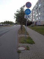
Radweg Ein Radweg ist baulich angelegt und als solcher zu erkennen. Ein Gehweg ist entweder nicht vorhanden oder verläuft durch einen Grünstreifen o.ä. getrennt etwas abseits des Radweges. |
| |
|
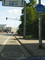
Radfahrstreifen mit durchgezogener breiter Linie (Fahrbahnbegrenzung) abgetrennter Streifen auf Fahrbahnniveau mit Radwegbeschilderung und Fahrrad-Piktogramm. |
| |
|
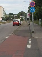
Getrennter Rad- und Gehweg Fußgänger und Radfahrer sind optisch/baulich von einander getrennt (Linie, farbiges Pfaster, usw.). |
| |
|
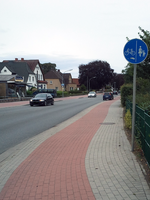
Getrennter Fuß- und benutzungspflichtiger Radweg |
| |
|
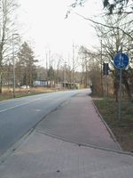
Gemeinsamer Geh- und Radweg |
| |
|
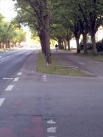
Keine Beschilderung |
|
Radweg ohne Benutzungspflicht: Ein Radweg ist baulich angelegt und als solcher zu erkennen. Ein Gehweg ist vorhanden und verläuft durch einen Grünstreifen o.ä. getrennt etwas abseits des Radweges. |
|
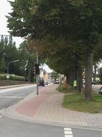
|
Getrennter Fuß- und Radweg ohne Benutzungspflicht: Fußgänger und Radfahrer sind nur optisch/baulich von einander getrennt (Linie, farbiges Pfaster, usw.). |
| |

|
Schutzstreifen |
| |
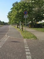
|
Radweg ohne Benutzungspflicht Ein Radweg ist baulich angelegt und als solcher zu erkennen. Ein Gehweg ist vorhanden und verläuft durch einen Grünstreifen o.ä. getrennt etwas abseits des Radweges. |
| |
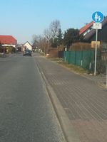
|
Freigegebener Gehweg |
|
Ein-, bzw. Zweirichtungsradwege
(keine Änderung)
Einbahnstraße mit Erlaubnis für Radfahrer in Gegenrichtung
(keine Änderung)
Rendering
An obligatory cycleway could be expressed by different line styles (darker blue) in comparison to an "normal" cycleway.
Routing
This proposal ensures that the value designated is not overwritten. So routers can reliably give cycleways tagged with bicycle=designated a higher priority than the main road way.
Affected Wikipages
- On Proposed features/Officially dedicated usage and
access=officialany references of obligatory/mandatory/compulsary usage should be removed bicycle=use_sidepathshould mention this new tag.- All the bicycle related wikipages which still need to be collected here.
Related Proposals
- Proposed features/obligatory usage
- Proposed features/Officially dedicated_usage
- Proposed features/Obligatory vs. optional cycletrack
Comments
Please comment on the discussion page


