Proposal:Use sidepath
| use_sidepath | |
|---|---|
| Proposal status: | Approved (active) |
| Proposed by: | PeeWee32 |
| Tagging: | bicycle=use_sidepath
|
| Applies to: | Highways with a classification that allows cycling generally without "bicycle forbidden sign" but with a parallel compulsory cycleway.
Countries that have compulsory cycleways. |
| Definition: | This is a highway (for example tertiary) with a classification that allows cycling generally without "bicycle forbidden sign" but with a parallel compulsory cycleway. |
| Statistics: |
|
| Draft started: | 2014-01-30 |
| RFC start: | 2014-03-16 |
| Vote start: | 2014-05-02 |
| Vote end: | 2014-05-16 |
NOTE: This proposal has been approved. Please see the wiki page.
The main reason for this new tag
This is a proposal for a new access tag. It is a tag to mark that it is normally not allowed to use the road on a bicycle. Instead use the compulsory cycleway.
What is the new proposal (use_sidepath)
This tag bicycle=use_sidepath applies only to roads with a classification that allows cycling generally. When this road has a parallel compulsory cycleway (e.g. ![]() or
or ![]() (DE, PL) or
(DE, PL) or ![]() or
or ![]() ) (NL) this tag can be applied. But only when this road does NOT have a traffic sign saying it is explicitly forbidden to ride a bicycle (e.g.
) (NL) this tag can be applied. But only when this road does NOT have a traffic sign saying it is explicitly forbidden to ride a bicycle (e.g. ![]() or
or ![]() ). In that case use the "bicycle=no". Legal and access implications may and will vary from country to country. The implications of these traffic signs on many specials vehicles and situations varies so much that it would need a lot of new tags to express this in OSM. There is no need to do this if the legal situation is clear. With a new country specific access scheme (=concept) on compulsory cycleways and their parallel roads it should give routers and renderers enough information for any type of vehicle/situation.
). In that case use the "bicycle=no". Legal and access implications may and will vary from country to country. The implications of these traffic signs on many specials vehicles and situations varies so much that it would need a lot of new tags to express this in OSM. There is no need to do this if the legal situation is clear. With a new country specific access scheme (=concept) on compulsory cycleways and their parallel roads it should give routers and renderers enough information for any type of vehicle/situation.
Rationale
Tagging Access
This tag will add access information to the OSM database. The absence of any "bicycle= " tag may give the impression that cycling is always allowed which is not the case when there is a parallel compulsary cycleway.
Routing
This tag will improve bicycle routing. A router can now decide to propose a route that does not use these type of roads.
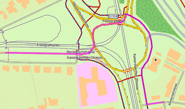
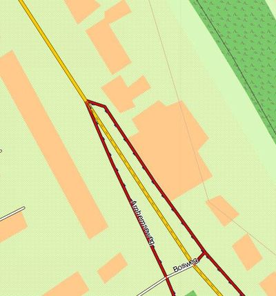
Because of the absence of a "bicycle=" tag routers propose routes that are illegal to take. Here are some examples.
Example1 from Openfietsmap Garmin map (cycleways are red or red/blue)
Example2 from the android app Osmand (cycleways are blue dotted, the route is purple)
Here is an example of the Android app Osmand. See how the app also fails to take the cycleway.
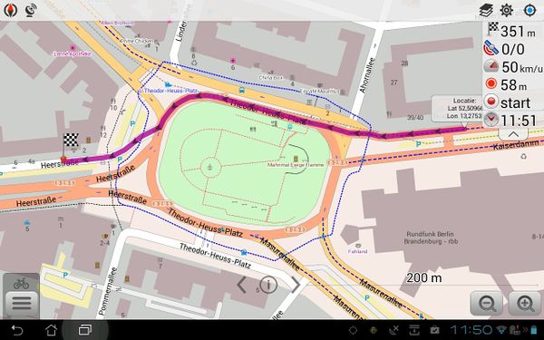
Below is how we like it to be.
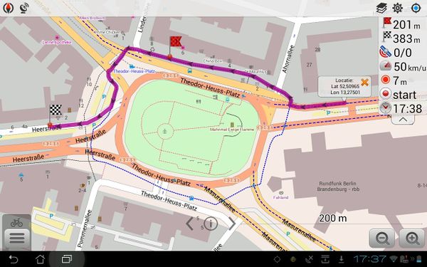
See the discussion page of the first proposal for more details about routing.
Rendering
A renderer can decide to render these kind of roads differently. A map can be made showing roads on which you are (not) supposed to ride with an ordinary (or exceptional) bicycle. The OSM based Openfietsmap for Garmin GPS devices uses the "bicycle=no" tag to add dashes to these of roads. This way a cyclist can see on his GPS device if he is allowed to ride on this road.
Something similar can be done with the bicycle=use_sidepath tag.
In Bremen (DE) some roads already have the bicycle=use_cycleway tag. This makes it possible to make a map showing bicycle=no, bicycle=use_sidepath (new proposal) and bicycle=use_cycleway (old proposal). Wait a little while for the lines to render.
Examples
| Picture | Tags |
|---|---|
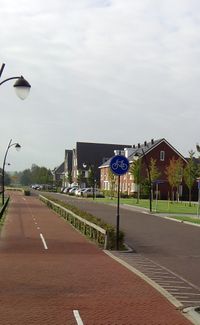 Cycleway: cycling is compulsory. |
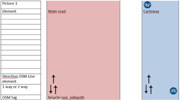
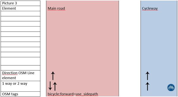
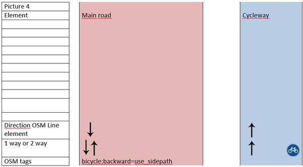
Cycleway:highway=cycleway(implicit: bicycle=designated)Main road: bicycle=use_sidepath
|
 (NL) (NL) (FR) (FR) (DE) (DE)Cycleway: cycling is NOT compulsory. |
Cycleway:highway=cyclewayPossible additional tags, i.e. tags that show that the cycleway is not compulsory or mofa=* tagsMain road: no explicit bicycle=* tags
|
 Cycling is explicit not allowed |
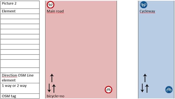
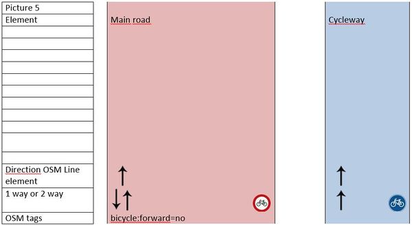
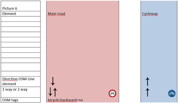
highway=*bicycle=no (explicit bicycle ban)
|
Some more examples in which all cycleways are compulsory cycleways.
Extra info about the last proposal (bicycle=use_cycleway) and some of our arguments
Read more here.
Links
On both the German forum (in English) and Dutch forum there have been discussions on how to tag these highways.
To support this tag a interactive map is made to highlight these (and other) roads.
bicycle=use_sidepath
|
|
bicycle:forward=use_sidepath
|
bicycle:backward=use_sidepath
|
OLD PROPOSAL
bicycle=use_cycleway
|
|
bicycle:forward=use_cycleway
|
bicycle:backward=use_cycleway
|
Voting
Please use {{vote|yes}} or {{vote|no}} and give your reasons to oppose. Use --~~~~ to sign your user name & date:
 I approve this proposal., also useful in Germany --chris66 (talk) 11:25, 8 May 2014 (UTC)
 I approve this proposal., it's also applicable in Belgium. --Escada (talk) 13:17, 2 May 2014 (UTC)
 I approve this proposal., we need this in the Netherlands to resolve problems with routing which will not be resolved easily in other ways; it has been discussed extensively on the Dutch Forum. Frankl2009 (talk) 19:40, 2 May 2014 (UTC)
 I approve this proposal., I've been following the discussions on this topic from the beginning and I'm certainly in favor of this well-condidered propodal.Avena701 (talk) 11:15, 5 May 2014 (UTC)
 I approve this proposal. --M!dgard (talk) 19:25, 6 May 2014 (UTC)
 I approve this proposal. --Hubert87 (talk) 10:42, 7 May 2014 (UTC)
 I approve this proposal. --Dieterdreist (talk) 11:31, 8 May 2014 (UTC)
 I oppose this proposal. --Foxxi59 (talk) 11:45, 8 May 2014 (UTC) Not required because the tag can be derived from the existing tags
 I approve this proposal. --Arndt (talk) 11:52, 8 May 2014 (UTC)
 I approve this proposal.--GeorgFausB (talk) 11:55, 8 May 2014 (UTC)
 I approve this proposal. --Scai (talk) 12:03, 8 May 2014 (UTC)
 I approve this proposal. --Nadjita (talk) 12:06, 8 May 2014 (UTC)
 I approve this proposal. --Bielebog this tag looks handy to assess this still widespread german bicycle road ban --Bielebog (talk) 12:08, 8 May 2014 (UTC)
 I approve this proposal. --streckenkundler (talk) 12:08, 8 May 2014 (UTC)
 I approve this proposal.because usefull in germany, less errors in JOSM, easier to map. --Microgamer (talk) 12:25, 8 May 2014 (UTC)
 I approve this proposal. --Farad (talk) 12:53, 8 May 2014 (UTC)
 I oppose this proposal. --KK-O (talk) 13:22, 8 May 2014 (UTC) bicycle=no means forbidden for bicycle and not depends on a sign. We don't tag for JOSM an renderers
 I approve this proposal. ----Hike39 (talk) 16:07, 8 May 2014 (UTC)
 I approve this proposal. ----austi1996 (talk) 19:39, 8 May 2014 (UTC)
 I approve this proposal. --Seawolff (talk) 21:59, 8 May 2014 (UTC)
 I approve this proposal. --ligfietser (talk) 20:03, 9 May 2014 (UTC)
 I approve this proposal. --Mondschein (talk) 23:29, 10 May 2014 (UTC)
 I oppose this proposal. for the same reasons I voted against https://wiki.openstreetmap.org/wiki/Proposed_features/Bicycle_use_cycleway --Fkv (talk) 14:09, 11 May 2014 (UTC)
 I approve this proposal. I don't think it is needed, but it is a lot better than putting bicycle=no on ways where it is not forbidden to ride a bike. --Imagic (talk) 08:18, 12 May 2014 (UTC)
 I oppose this proposal. because information can also be derived from cycleway:left/right=sidepath cycleway:left/right:bicycle=designated proposed in German DE:Bicycle/Radverkehrsanlagen_kartieren_Lübecker_Methode, which is used quite a lot (see below) --StefanKurzbach (talk) 09:31, 15 May 2014 (UTC)
 I approve this proposal. Thank you for the very well-documented proposal. Math1985 (talk) 20:32, 15 May 2014 (UTC)
Result: 22 Approvals and 4 Opposals. Congratulation!--Hb 05:57, 1 June 2015 (UTC)
cycleway:left=sidepath
|
cycleway:right=sidepath
|
cycleway:left:bicycle=designated
|
cycleway:right:bicycle=designated
|
