Tag:information=guidepost
| Description |
|---|
| Used to mark a guidepost/signpost |
| Rendering in OSM Carto |
| Group: tourism |
| Used on these elements |
| Requires |
| Useful combination |
| Status: de facto |
| Tools for this tag |
|
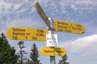
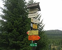
Guideposts (aka fingerposts or finger posts) are often found along official hiking/cycling/riding/skiing routes to indicate the directions to different destinations. Additionally, they are often named after a region or place and show the altitude.
The position of a signpost can be used by a hiker/biker/rider/skier as a confirmation of the current position, especially if they use a printed map without a GPS receiver.
The content of the sign can be tagged using either destination=* on the corresponding way or Relation:destination_sign for a more complete representation - see also below in Destinations
How to map
Create a node at the exact position and tag with the following values. Please do not tag a crossroads as a guidepost.
To describe the type(s) of the shown route(s), use the tags hiking=yes, bicycle=yes, mtb=yes, horse=yes or ski=yes. Note that these tags don't describe the legal access to the guidepost. To make this explicitly clear instead of e.g. hiking=yes you could alternatively use guidepost:hiking=yes or guidepost=hiking, though this is less common, not widely supported and would add no additional meaning.
| Tag | Required | Description |
|---|---|---|
| tourism=information | required | To define it as touristic point. |
| information=guidepost | required | |
| guidepost=* | optional | used to describe what it is related to, e.g. hiking |
| guide_type=* | optional | used to describe what type it is, e.g. destination, see also information=route_marker |
| name=* | optional | The name of the place inscribed on the guidepost, if there is one. |
| ele=* | optional | Inscribed height of place above sea level in metres. |
| ref=* | optional | Reference number of the guidepost. |
Destinations
There are currently three options how to tag the contents of the signs. These are mostly complementary and not competing, because they all offer different amounts of detail:
- destination=* on the signpost. Note that no information about the direction the sign points to is given, so this describes the signpost itself, but not its relation to ways or intersections. If several destinations are given, they are separated by a
;.- The Italian CAI uses an extended scheme, separating the individual arrows by vertical bars (
|). Multiple destinations on one single arrow are still separated by semicolons (;). See CAI#Luoghi di posa.
- The Italian CAI uses an extended scheme, separating the individual arrows by vertical bars (
- Relation:destination_sign is used for the most complete description. Distances, walking times, symbols and directions can also be given explicitly. This is the most complex tagging scheme as it requires its own relation with at least three members for each direction the sign points to. There are about 100k relations of this type in the database (Aug 2019).
- There is a third scheme that was added to the German Wiki page some years ago that combines simple tagging and gives approximate information about direction (direction_north=*, direction_east=*, ... direction_northeast=*). As of August 2019, these tags had been used about 20k times. By July 2023, they were used 95k times.
Examples
| Photo | Tagging |
|---|---|

|
|

|
|

|
|

|
Rendering
See also
- tourism=information + information=route_marker - A marker that shows the position of the way. Could be a symbol, a short pole or a painted marking
- Relation:destination_sign - Destination signs at or before intersections
- direction_north=*, etc. - Directions on destination signs
- destination=* - Destination when following a linear feature
- osmc:symbol=* - Machine-Readable representation of route symbol that is used as waymarker or on guideposts
- route=hiking / route=bicycle - tagging of signed hiking or bicycle routes using relations
- trailblazed=* - A key for the use on paths or tracks which are marked.
- Proposed features/Guidepost - Original guidpost proposal
- Proposed features/information - To differ between offices and other information sources tagged with tourism=information
- https://hiking.waymarkedtrails.org / https://cycling.waymarkedtrails.org - Waymarked Trails: Hiking / Waymarked Trails: Cycling