Tajikistan
| V・T・E |
| latitude: 38.8, longitude: 70.8 |
| Browse map of Tajikistan 38°48′00.00″ N, 70°48′00.00″ E |
| Edit map |

|
|
External links:
|
| Use this template for your locality |
Tajikistan is a country in Central Asia at latitude 38°48′00.00″ North, longitude 70°48′00.00″ East.

Welcome to all mappers interested in mapping or visiting Tajikistan!
This page is mostly maintained by the (young) OSM community in Tajikistan! Feel free to reach out and / or to edit directly this wiki page!
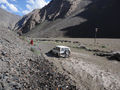
- A few impressions from our beautiful country :-)
-
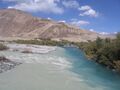 Rivers joining in Batchor
 -
 Statue of Rudaki in Dushanbe
 -
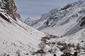 Winter landscape in Ravmeddara
 -
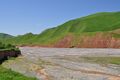 Low tide in Southern Khatlon
 -
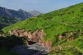 Green landscape in Southern Khatlon
 -
 Yak in Bulunkul
 -
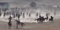 Buzkashi in Hissor
 -
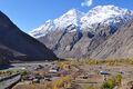 Mountaineous landscape in the Tajik Pamirs
 -
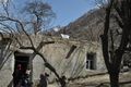 Traditional pamiri house
 -
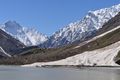
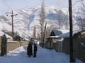 Winter landscape in Khorog
 -
 Flood in Bartang valley
 -
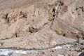 Rockfall in Ravmeddara
 -
 Spring avalanche nearby the Pyanj river


Mappers
Please list below your OSM identity, as well as your area of expertise
Currently active mappers
| Wiki Identity | OSM Identity | Area of expertise |
|---|---|---|
| shenriod | https://www.openstreetmap.org/user/shenriod | GBAO |
| Maailma | https://www.openstreetmap.org/user/Maailma | Mu'minobod |
| naranjasol | https://www.openstreetmap.org/user/naranjasol | |
| Please add yourself :-) | ||
Previous mappers (apparently currently not active):
| Wiki Identity | OSM Identity | Area of expertise |
|---|---|---|
| merchant | https://www.openstreetmap.org/user/merchant | - |
| pamirbluesky | https://www.openstreetmap.org/user/pamirbluesky | GER |
| Gulbahor | https://www.openstreetmap.org/user/Gulbahor | Khorog |
| Furough | https://www.openstreetmap.org/user/Furough | Khorog |
Projects and organized mapping activities
Project "Participatory mapping in Tajikistan" (February 2021 - January 2022)

This pilot project is supported by the project "Technology Based Adaptation to Climate Change in Rural Tajikistan and Kyrgyzstan", implemented by GIZ on behalf of the German government and is jointly implemented by Little Earth (Tajikistan) and CartONG (France). You can find more details on the dedicated page: Tajikistan/Participatory mapping in Tajikistan.
iSHAHR Dushanbe Mapathons (July 2018)
In July 2018, students at American Space Dushanbe contributed to the mapping of amenities in Dushanbe, adding over 500 businesses to existing data. The data may already be out of date with many new construction and demolition projects going on in the city; there may also be some duplicates in the data. Please feel free to contribute more up-to-date local knowledge. The mapping was coordinated using EpiCollect5. In addition, students at American Space Dushanbe spent Jan 2018 - July 2018 contributing to building polygons in Dushanbe through a project in the HOT Tasking Manager.
Import of Administrative Boundaries from GADM (October 2013)
In October 2013, import of Province and District boundaries from GADM 2.0 (http://www.gadm.org) into relations has been finished (please see discussion page for pending license issue). They can be quite a bit off, however (5 km in one observed case, but could be more). So if you have local knowledge, a better database or if you find that the shown boundaries reflect the shape of a nearby physical object (e.g. the winding of a river, a ridge), but are besides it, please feel free to adapt. Make sure to document changes in the "source" tag.
Initial mapping of Khorog (July 2012)
A QuickBird image (taken April 20th 2010) had been purchased for the mapping of the town of Khorog. The core of the mapping has taken place between July 28th, 2012 and August 1st, 2012. The mapping has been coordinated through the HOT Tasking Manager.
See the poor coverage before:

and compare it with the detailed coverage on August 2nd, 2012:

The current state can be seen here.
NB: A report from the ICRC (Dec 2012) mentions this mapping exercise: http://www.un-spider.org/sites/default/files/Rebois.pdf
Common tags
The goal of this section is to present the main tags that can be used in the context of Tajikistan. As Tajikistan is still very poorly mapped on OSM, it is important to focus on a few main features (road network and settlements). The list below however is nothing but a suggestion, and no mapper should be prevented from adding any other tag, if they feel that sufficient source information is available.
Settlements and villages
| Key | Value | Element | Comment | Rendering | Photo |
|---|---|---|---|---|---|
| place | town | A settlement with between 10,000 and 100,000 inhabitants. | 
|

| |
| place | village | A settlement with between 500 and 10,000 inhabitants. | 
|
||
| place | hamlet | A settlement with between 100 and 500 inhabitants. | 
|
Buildings
| Key | Value | Element | Comment | Rendering | Photo |
|---|---|---|---|---|---|
| building | house | A single dwelling unit inhabited by family or small group sharing facilities such as a kitchen. | 
|

| |
| building | apartments | A building arranged into individual dwellings, often on separate floors. |
|

| |
| building | yes | Use this tag if you don't know which one to use. In case of doubt, this should be considered the default tag. |
|
Additional information about the building can be added, e.g. about the material used for construction
Facilities
Public facilities
| Key | Value | Element | Comment | Rendering | Photo |
|---|---|---|---|---|---|
| amenity | hospital | Shows the location of a hospital, i.e. institutions for health care providing treatment by specialised staff and equipment. This does not include amenity=dentist.Beside the name tags, please include / set the following tags to this feature: contact:phone=*,emergency=*,building:levels=*, addr:city=*, addr:postcode=*, addr:street=*,addr:housenumber=* and operator=*.
|
 |
||
| amenity | school | Shows the location of a school, including primary and secondary schools. For other educational buildings please use amenity=education_centre. Beside the name tags, please include / set the following tags to this feature: building:levels=*, addr:city=*, addr:postcode=*, addr:street=*,addr:housenumber=* and operator=*.
|
|

| |
| amenity | kindergarten | For children too young for a regular school (also known as preschool, playschool or nursery school), in some countries including afternoon supervision of primary school children.. | 
|
 | |
| amenity | bus_station | Place where privat cars gather passangers to a specific destination. Indicate in the key:name the destination of the cars, e.g. "Bus Station to Iskashim" or "Bus Station to Bartang Valley" |  |
Commercial facilities
| Key | Value | Element | Comment | Rendering | Photo |
|---|---|---|---|---|---|
| amenity | bank | Shows the location of a bank branch. Beside the name tags, please include / set the following tags to this feature: atm = (yes/no), opening_hours, addr:city, addr:postcode, addr:street, addr:housenumber, contact:phone. |  | ||
| shop | bakery | Shop focused on selling bread of their own production |  |
 | |
| shop | convenience | A small local shop carrying a small subset of the items you would find in a supermarket, locally known under the russian word "Magazina" |  |
 | |
| amenity | pharmacy | A shop where a pharmacist sells medications |  |
 | |
| shop | cosmetics | Shop focused on selling cosmetics |  |
 | |
| shop | electronics | Shop focused on selling consumer electronics (TV, radio, batteries …). Larger ones may also sell computers, fridges, … |  |
 | |
| shop | hairdresser | Here you can get your hair cut, coloured, … See also shop=beauty
|
 |
,_October_2009.JPG) | |
| shop | mobile_phone | Shop focused on selling mobile phones and accessories. Tag mobile provideres like TCELL, Megaphone, Babylon etc. under this tag too. |  |
 | |
| shop | supermarket | Supermarket. In Khorog mainly the big convenience stores |  |
 |
Roads, Streets and Paths
Those tables are a subset of Template:Map_Features:highway. Some illustrations are adapted to better depict the situation in Tajikistan.
Roads
| Key | Value | Element | Comment | Rendering | Photo |
|---|---|---|---|---|---|
| highway | primary | Main asphalted roads linking the cities.
Examples: Pamir Highway, road Dushanbe - Khujand, road Dushanbe - Hissor - Rigar... |

|

| |
| highway | secondary | To be used for most of the roads that are neither main links nor small tracks. Usually unpaved (or poor and uneven pavement), but accessible to motorized vehicles (not only to 4x4).
Examples: Bartang road, road to Bulunkul, Vanj road, Khorog-Ishkashim-Langar road... |

|

| |
| highway | track | Rough roads, only accessible to 4x4 vehicles.
Examples: road to Bachor, road to Turumtai-kul from Gunt and from Jawshangoz... |

|

| |
| highway | residential | Roads which are primarily lined with housing, but which are of a lowest classification than tertiary and which are not living streets.
Examples: small streets in Gulaken, in upper UPD... |

|

| |
| highway | road | Use this tag if you don't know which one to use. In case of doubt, this should be considered the default tag. | 
|


Paths
| Key | Value | Element | Comment | Rendering | Photo |
|---|---|---|---|---|---|
| highway | path | Most paths in Tajikistan are accessible to walkers, horses, donkeys, bicycles and sometimes 4x4 cars.
Examples: path to Jezev, path between Khijez and Ravmed, path above Khufak (above the stadium in Khorog)...Examples: path to Jezev, path between Khijez and Ravmed, path above Khufak (above the stadium in Khorog)... |

|

|
Other tags
Other possible tags are listed here.
Data sources
Currently (June 2021) the Maxar Premium imagery seems to consistently offer the best quality in rural areas of Tajikistan, when compared with the other images that are made available by default in the main OSM editors (Bing, etc.). But please make sure to always check if more recent imagery is available, especially in urban areas, where new buildings and construction sites are appearing everyday.
UAV images
Some areas have been surveyed by drones / UAVs and the images have been made available for mapping in OSM