Tag:amenity=school
 |
| Description |
|---|
| A primary or secondary school (pupils typically aged 6 to 18). |
| Rendering in OSM Carto |

|
| Rendering in OSM Carto |

|
| Group: education |
| Used on these elements |
| Implies |
| Useful combination |
|
| See also |
| Status: approved |
| Tools for this tag |
Use amenity=school to identify a place where pupils, normally between the ages of about 6 and 18 are taught under the supervision of teachers. This includes, according to the ISCED:
- primary schools (ISCED 1, tagged with
isced:level=1) and - secondary schools (ISCED 2 and 3, tagged with
isced:level=2;3), in some countries called high schools.
For other educational establishments, see
amenity=kindergarten(ISCED 0),amenity=collegeandamenity=university(ISCED 5-8)amenity=trainingfor courses and training (like driving schools, dance schools, etc.)- further facilities.
For school grounds, see the feature landuse=education.
How to map
There are several standard situations regarding schools. Each school should be mapped only once. Don't double them.
Other relevant information can be added with the following tags:
operator=*– Name of operator, often the local education authority.operator:type=*– type of operator, e.g. community / religious / private / governmentaddr:*=*and other contact information such asphone=*,email=*,website=*... /contact:*=*capacity=*, the maximum number of pupils the school can acceptgrades=*– Which grades the school provides, can be used in conjunction withisced:level=*min_age=*andmax_age=*to indicate age range of children that attend the schoolfee=yesif the school requires a direct charge for core services.religion=*, if the school is associated with a particular religion (alsodenomination=*)school:gender=*to indicate which genders can go to the schoollanguage:*=*orschool:language=*to indicate which is the main language of the schoolref=*, if school has a reference numberwikipedia=*orwikidata=*if the school has a Wikipedia- or Wikidata-entry.pedagogy=*if the school has adheres to a particular pedagogical philosophy (e.g., Steiner or Montessori)
Single school on one site
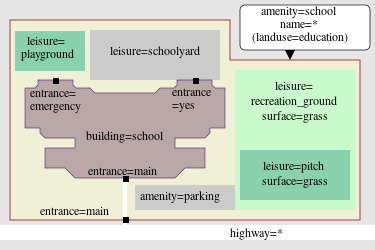
If you have a single school on one ground, mark the boundary of the school using an area ![]() or place a node
or place a node ![]() in the middle of the site if you are in a hurry (or don't have access to information about the boundary and it is not obvious from aerial imagery). If you use an area
in the middle of the site if you are in a hurry (or don't have access to information about the boundary and it is not obvious from aerial imagery). If you use an area ![]() it is also optional to mark the area with
it is also optional to mark the area with landuse=education too, but it is not necessary.
Multiple schools on one site
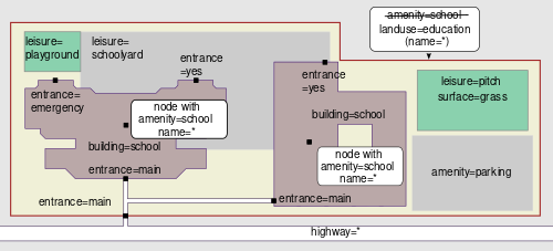
When one or more schools share their grounds use the following schema. This also applies when schools share a site with other amenity=*.
- Mark the outer boundary of the shared school grounds/campus/area using an area
 with the tag
 landuse=education. If this shared area has its own name, tag this as well. - For each school or other amenity tag a node
 at an appropriate place within this area, or if the school has its own building for its exclusive use on the grounds, add the amenity-tag to the building outline
  . Make sure that there is only one OSM element for each school. Add the school's details to the relevant amenities.

School with multiple sites
If a single school occupies a non-contiguous campus, it should be represented by a multipolygon relation that includes all the parts of the campus. If part of the campus can only be represented by a point for some reason, then a multipolygon would not be valid, but a site relation has sometimes been used as an alternative.[1] Either way, make sure to use amenity=school and other tags on the relation.
Multiple school campuses operated by the same organization should be separate amenity=school areas. Do not use a relation to express the relationship between the campuses; instead, tag each campus with a matching operator=*, brand=*, or owner=* tag.
Rooms within the buildings
Also see
- Simple_Indoor_Tagging – Model indoor areas
- Simple_3D_Buildings – 3D Buildings
School classification
Many regions distinguish primary and secondary schools more granularly than amenity=school alone, but more discretely than grades=*, min_age=*, and max_age=*. A few different schemes exist for classifying schools:
school=*– ad-hoc keywords based on age group or specializationschool:type=*– UK terms for funding source or governance modelisced:level=*– a numeric scale based on an international statistical normalization scheme based on national education programsschool:orientation=*– Currently used in Belgium to indicate what a secondary school prepares for.
Campus details
Several details can be added when drawing the complete school campus.
building=schoolis used for purpose-built school buildings (reused buildings keep their building type).- appropriate additional tags can be added to the building, for example
leisure=swimming_pool. entrance=*and if appropriatebarrier=gatecan be considered for the points where roads, paths or other access routes into the school grounds cross the boundary of the school. Building entrances can be mapped with a node on the building outline, with one of the following tags:leisure=pitchis used for individual sports pitches. Where an individual sport can be identified,sport=*andsurface=grass/asphalt/...can be added.leisure=sports_hallis used for indoor sports facilities, if purpose-built withbuilding=sports_hall.landuse=grassis used for areas of grass, possibly covering multiple pitches or used for other purposes.leisure=schoolyardis an open space in schools, specifically for recreation but usually without playground infrastructure. It is typically concrete or asphalt and most often in urban areas. In American English it is often referred to as a "blacktop". Often micro-mapped with additional areas forplayground=hopscotch/map/four_square/...and others.leisure=playgroundis often found on primary school grounds with infrastructure such asplayground=structure/swing/...and others.amenity=canteena canteen which sells full sit-down meals
Country-specific rules
As school systems vary over the world, some country-specific tagging schemes have been developed. Please, refer to the following wiki pages for regional information:
| Country or region | Wikipage |
|---|---|
| Belgium | Conventions |
| Brazil | Recommendations |
| France | Specific rules |
| Mali | school:ML=* and school:ML:academie=*
|
| Philippines | Conventions for tagging schools |
| United States | United States/Tags#Schools |
Disambiguation
Typical facilities outside the scope of amenity=school are:
amenity=college– Institute of Further Education (similar to Continuing Education). Not the same as a "college" in American English.amenity=university– universitiesamenity=kindergarten– kindergarten, play group or preschoolamenity=training– specialized training institutions, such as driving schools, dance schools, etc.amenity=preschoolamenity=kindergartenoramenity=childcare- Speciality schools:
amenity=dancing_school– also seeleisure=dancedance:teaching=yesamenity=driving_school– motor vehicle driving lessonsamenity=traffic_park– traffic schools oriented toward childrenamenity=flight_school– proposed. Flying schools. Also seeamenity=collegeamenity=language_school– an educational institution where one studies a foreign languageamenity=music_school– music schoolamenity=prep_school– standardized test preparation school, other than a British preparatory school (which nominally prepares for the w:Common Entrance Examination), or an American college-preparatory school (for which, useamenity=school).amenity=ski_school
Rendering
Possible tagging mistakes
See also
school=*– The type of school.education=school– has been approved for tagging all education features.
Notes and references
- ↑ For example, this school occupies multiple classrooms scattered about a campus shared with other schools. Each classroom is mapped as a point because the exact indoor layout of each building is unknown. Since a valid multipolygon cannot include a point as a member, a site relation is the next best representation of this school. A
 label
label
