Puerto Rico basic guide
This guide will help you understand the basics of OSM in Puerto Rico context.
General guide for roads
Roads are know as "ways" in OSM.
Some general rules for highways:
Use the tag name=* to add the name of a road, for example name=Calle Jose Cuevas.
Use the tag ref=* to add the number of the road, for example ref=PR-2.
Use the tags highway=motorway_link, highway=primary_link, highway=secondary_link, highway=tertiary_link to indicate a ramp or part of the road connecting two types of roads (an exit). When possible use the direction of the traffic to determine the type to use, for example exiting from a motorway to a primary is a primary_link.
When adding an exit you should add the tag destination:ref=*. For example an exit to PR-2 from PR-107 will have the tags highway=trunk_link and destination:refPR-2=*.
To indicate a sidewalk use sidewalk=left, sidewalk=right, sidewalk=both or sidewalk=none.
To indicate a bicycle lane use cycleway=left, cycleway=right, cycleway=both or cycleway=none.
The speed of a road is set with maxspeed=50 mph (notice the space between the speed and the unit).
Use the access tag to specify if a road is not for general public access for example access=private, access=customers, access=no.
For a dead-end select the last node in the road and add the tag noexit=yes.
Interstate Highways (Interestatal)
In PR it is only used for PR-22, PR-52, PR-53, (autopistas) toll based roads that form part or receive funding from the National Interstate Highway System.
These ways should be tagged as highway=motorway , a junction or ramp to the interstate is tagged as highway=motorway_link .
Primary Roads
In Puerto Rico a primary road is an important road that connects the different regions (districts) and towns (pueblos) (PR-1, PR-2, PR-3, PR-111, etc). In general it has full size lanes in both directions, in many cases the lanes have a division or more than one lane in one direction.
Official Definition:
Red primaria: facilita el movimiento de pasajeros y cargas entre las regiones principales de la Isla. La componen las autopistas y segmentos de otras vías con altos estándares de diseño. Se le ha asignado a esta red el marcador de ruta M1-6A.[1]
The signs for these roads have the blue shield with the number on a white background. View image of Primary Road Signs
We tag these roads with highway=primary. Add the road number with the tag ref=PR-111.
When the road has a division trace each individual road for a given direction and tag them with the oneway=yes. Make sure you trace the road on the direction the traffic flows.
Secondary Roads (inter-municipal)
These are the roads that connects towns (eg PR-110) is usually smaller than a primary road. In PR these are usually a one lane on each direction roads.
The signs for these roads are an inverted blue elongated shield with a yellow border inside. View image of Secondary Road Signs
We tag these roads with highway=secondary. Add the road number with the tag ref=PR-110.
When possible you should trace road divisions and splits. When drawing this road mind the direction and use the oneway=* tag accordingly.
Tertiary Roads
These roads provide access to the center of a town from the town communities and peripheral areas.
The signs for these roads are a white oval on a black background. View image of Tertiary Road Signs
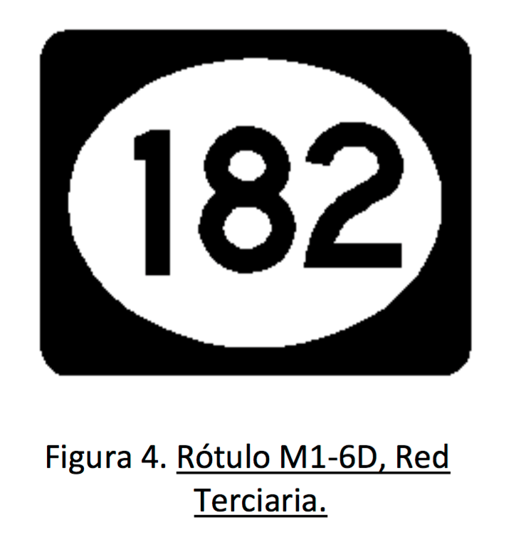
We tag these roads with highway=tertiary. Add the road number with the tag ref=PR-110.
Private Service Roads
Use the tag highway=service to identify a private service road. Add the tag access=private to these roads. Examples of when to use it:
A road to, or within a business (private, industrial, agricultural, parking, or even government) location or property.
For small roads (entrance) (concrete, asphalted, or dirt road) that takes you to one or more houses (varias familias). This road is mainly meant for those residents and is not considered a public road. This way is longer that the usual drive to the garage (marquesina, etc), in idea more than a 100 meters. A small driveway is tagged instead with service=driveway.
Residential Roads
Use the tag highway=residential to identify small roads within a residential area (eg: urbanización, barrio, etc). There main purpose is to give access to a residential locations and not to connect distinct areas. Residential roads usually branch out from tertiary and secondary roads.
A lot of Puerto Rico roads will be tagged with highway=residential in particular roads managed by the municipality, town roads, and roads in rural areas. Be careful to make sure that the road is not a tertiary road, remember tertiary roads have a State assigned road number.
Parking Area
You should always trace a polygon with the area of the parking. This area should be tagged with amenity=parking.
The road that make the actual parking aisles in the parking area should be tagged with highway=service and service=parking_aisle.
The main roads on the parking lot that connects to the entrance, exits and different areas should be tagged only with highway=service.
Gas Station
Use the following tags when adding a gas station.
Mark the polygon for the building with amenity=fuel, building=yes. When possible add the name with the tag name=Gulf.
Create the road to access the gas station with the tags highway=service and access=customers.
Parks
A green area within a town or city is tagged with landuse=recreation_ground and leisure=park.
A National, State or Municipal natural forest or reserve is tagged with leisure=nature_reserve and boundary=national_park.
A path or walkway inside a park is tagged with either highway=path or highway=footway.
Touristic Places
The tag tourism=* can have the values attraction, information, museum, and viewpoint.
If the place has a historic significance add a historic tag. Some common ones are historic=monument, historic=building, historic=memorial, historic=castle, or historic=yes.
See also
Good guides you should read:
References
- ↑ GUÍAS PARA LA SELECCIÓN E INSTALACIÓN DE RÓTULOS DE ORIENTACIÓN, DTOP http://www.dtop.gov.pr/fotos/transito/mutcd2009.pdf