Tag:barrier=gate
 |
| Description |
|---|
| A section in a wall or fence which can be opened to allow access. |
| Rendering in OSM Carto |
| Group: barriers |
| Used on these elements |
| Useful combination |
| See also |
| Status: approved |
| Tools for this tag |
|
A gate is a section in a wall or fence which can be opened to allow or restrict access. They are usually made of wood or metal.
How to map
On a node
On a way barrier=wall/fence/etc. add a node with the tag barrier=gate at the gate's location.
For general information on how to map barriers as nodes refer to: Key:barrier § How to map barrier nodes.
On a way
Tag a way with barrier=gate on the real position and width of the gate, this should be connected to the fence at either side of the way.
Add a node on the intersection between any footways and the gate, also tagged with barrier=gate, much like how crossings are mapped. (This helps routers as many will just ignore the gate if there is no node.)
- Example (in JOSM editor)
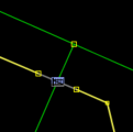
Correct: Gate as node on intersection between footway and gate way.

Tags used in combination
- amenity=ticket_validator
- height=*
- maxwidth=*
- access=*: access=yes, access=private, etc.
- open=*, whether the gate stands usually open
- locked=*, whether the gate is usually locked and not accessible without the key.
Example
Based on the location below, the gate node should be the end of a way. A new way starts with the gate node and it should have the access set to private if the access is restricted.
+------+------•××××+××××+

See also
- barrier=*
- barrier=wicket_gate — a pedestrian door or gate (note that barrier=gate is typically used instead).
- barrier=lift_gate
- barrier=swing_gate
- barrier=sliding_gate
- barrier=kissing_gate
- barrier=entrance
- barrier=cattle_grid
- barrier=chain
- barrier=sally_port
- building=gatehouse
- gate:type=*