Tag:man_made=bridge
 |
| Description |
|---|
| The outline of a bridge, grouping together all features for that bridge. |
| Rendering in OSM Carto |

|
| Group: man made |
| Used on these elements |
| Useful combination |
| See also |
| Status: approved |
| Tools for this tag |
|
The tag man_made=bridge is used to tag a bridge defined by the outline of the bridge. It is suitable to group together all ways running over that bridge and for holding descriptive tags for that bridge (the object represents the bridge as a whole) and to mark shape of the bridge construction.
How to map
Draw the outline of the bridge as ![]() area and apply man_made=bridge and layer=* to it. The outline should encompass the continuous structure of the bridge.
area and apply man_made=bridge and layer=* to it. The outline should encompass the continuous structure of the bridge.
Additional tags on the man_made=bridge outline:
- name=* - name of the bridge
- layer=* - to describe the vertical relationship with surrounding features
- surface=* - the surface covering the bridge
- bridge:structure=* - Load-bearing architecture of a bridge
- bridge:support=* - Cables and pylons beside the bridge
Ways on and under the bridge:
- connect the road
 ways running over the bridge to the man_made=bridge outline where the ways cross the outline. Mark these ways with bridge=*
 - Do not connect the ways running under the bridge to the outline
- Some mappers add covered=yes to segments of highway=* which pass under the man_made=bridge outline, but this is controversial
Delimiting a bridge
Ideally, each end of the bridge should correspond to the point where the bridge's abutment ends and an opening begins below the bridge. This point is clearest in street-level imagery. In aerial imagery, an expansion joint may appear as a thin line running across a road bridge's pavement at the point where you should begin or end the bridge. Parts of the bridge's structure, such as a guardrail or approach slab, may extend beyond this point but are not included in the bridge area. A bridge may have a different surface than the adjoining roadway, for example a wooden pedestrian bridge, making it easier to determine the shape of the bridge. However, a concrete bridge along an otherwise asphalt-paved road may also have a concrete approach slab, so look for an expansion joint if there is one.
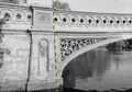
This bridge's area excludes the ornate railing and abutment to the left (indicated by the dashed line).
This bridge's area extends approximately to the fence at the top of the slope.

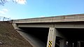
A close-up of an expansion joint (the black line running across the bottom).

This bridge's area extends over the roadway, but it is probably more appropriate to map the sidewalk as going through a tunnel, rather than under a bridge.

Sometimes it isn't possible to tell from above exactly where the opening below the bridge begins, so use your best judgment.

.jpg)


Bridges with more than one level
The same as before but the key layer=* should now contain the lowest number of all the features on the bridge. To group together all features of the bridge the proposed relation bridge is now used and the outline tagged with man_made=bridge is added as outline-member to that Relation of the bridge itself should be added to the relation.
A new (alternative) proposal to map multi-level bridges using level=* and location=bridge is described in Proposed features/Simplify man made=bridge mapping#Multi-level bridges
Objects and features on bridges
See proposal objects on bridges for tagging with bridge=* or location=bridge and proposal Relations/Proposed/Bridges_and_Tunnels for using bridge relations.
Landuse/natural areas around bridges


The ways under and on the bridge should not be attached to any landuse/natural area around the bridge.
At layer 1, the bridge outline can be attached to the natural/landuse on which the roads are mapped.
At layer 0, landuse/natural areas may pass under the bridge; these layer 0 areas can cross the bridge outline without nodes at the crossing points.
The outline of the bridge can be attached to landuse/natural areas, from the corner at layer=1 down to the point where the bridge starts to span over the air. If the landuse/natural area continues further down, e.g. to a water body below the bridge, it is usually connected to that natural=water body at layer=0. This lower point may actually be under the bridge, which means the node is positioned within the bridge outline but not attached to it. This can be adjusted according to survey or viewer images.
However, if the abutment is a straight down wall from the bridge outline down to the water, the lower connection point can be attached to the bridge outline. It then represents a straight line from the bridge down to the water.
Bridge ramps
Solid ground bridge ramps can significantly extend the overall space needed to construct a bridge. Like abutments, piers, pylons, etc. they are a bridge supporting structure. Solid ramps leading to a bridge abutment should not be part of a man_made=bridge outline. For significant structures bridge:support=ramp could be used instead on a separate outline, however there has not yet been a proposal for this specific tag.
In some cases the incline of ramps continues, not settling at the abutment. This can be mapped with incline=* on the bridge way. As a rule of thumb, if there is an opening beneath inclined ways, it should be a part of man_made=bridge outline, otherwise bridge:support=ramp. In most cases the abutment serves as a delimiter.
Examples
One or more ways, one level

A bridge represented by only one OSM way, the outline is not drawn yet. The way itself is tagged with bridge=yes and layer=1. Draw the outline.

A bridge represented by two OSM ways, both of them at the same level. The ways are tagged with bridge=yes and layer=1. The outline is drawn and tagged with man_made=bridge and layer=1. The OSM ways are connected to the outline.
If the bridge has a specific name it would be added to the outline.
Multiple ways, two levels

A large bridge with two carriage ways and a cycleway running below those. For better visibility only a part of the bridge is shown and the outline is displayed as a red-dashed line.
The OSM ways of the roads are tagged with bridge=yes and layer=2. The cycleway is tagged with bridge=yes and layer=1. The outline is drawn and tagged with man_made=bridge and layer=1. The proposed relation bridge is used to combine all features together and the OSM way of the outline is added as the outline-member to the relation.
The name of the bridge would be added to the relation.
See also
- bridge:structure=* - Load-bearing architecture of a bridge, can be added on man_made=bridge (note: there is no known solution for tagging bridges with mix of different structures)
- building=bridge - A building used as a bridge
- bridge=* - Mark a way as leading over a bridge and type of bridge
- bridge:movable=*
- start_date=* - Date when feature opened or the construction of the feature finished
- architect=* - Specifies the name of whoever architected the thing being tagged
- bridge:support=* - Position of the structures which support a bridge from beneath
- man_made=wildlife_crossing - Structure that allow animals to cross human barriers safely
- Drafted proposal for man_made=tunnel
- man_made=tunnel - Indicate the outline of a tunnel and group together all features for that tunnel
- Approved proposal for man_made=bridge
- Proposed relation for bridges and tunnels
- New proposal to refine some aspects of man_made=bridge
- Discussion on the tagging mailing list: Part 1 and part 2
- OverpassTurbo query that finds objects on bridges without nearby man_made=bridge